Weather
Strong Weekend Storms In NJ To Follow Brutal Heat
An ugly weekend is expected after excessive heat plagues New Jersey.


You may want to bring that party inside this weekend, because the weather isn't supposed to give us a break from the brutal heat.
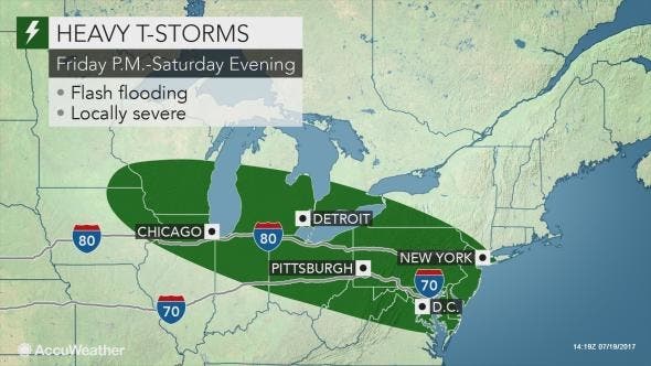
Rounds of thunderstorms with torrential rain and gusty winds are expected to roll through New Jersey this weekend. The National Weather Service has issued a hazardous weather outlook for the whole state, saying storms are expected to hit after temperatures shoot toward 100 degrees.
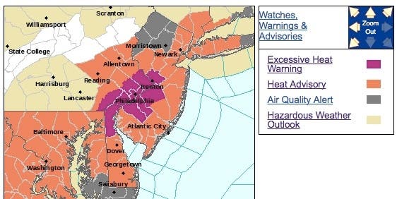
An excessive heat warning and other related advisories have also been issued. The heat index is expected to hit between 100 and 105 in southeast Pennsylvania and central New Jersey on Thursday. The storms will then begin to hit New Jersey after 6 p.m. on Friday.
Find out what's happening in Toms Riverfor free with the latest updates from Patch.
The weather pattern will raise the risk of flooding and isolated damaging winds, according to AccuWeather.
"A weather setup such as this has produced storms with flooding in the past," according to AccuWeather Chief Meteorologist Elliot Abrams.
Find out what's happening in Toms Riverfor free with the latest updates from Patch.
A third series is likely from later Saturday to Sunday. This batch is most likely to affect a broad area with perhaps less intense rainfall but isolated incidents of flash flooding. Some communities may receive upwards of 4 inches of rain, according to an AccuWeather release. If you plan on spending time at campgrounds near streams and rivers, you should be careful and keep up to date on the latest forecast, AccuWeather recommends.
"Exactly where the temperature contrast zone sets up each day will determine the main path of the storms and areas at greatest risk for damage and disruptions from flooding and strong winds," AccuWeather Senior Meteorologist Dave Dombek said.
Here is the forecast:
- Thursday: A slight chance of showers and thunderstorms after 1pm. Mostly sunny, with a high near 96. Heat index values as high as 105. West wind 6 to 9 mph. Chance of precipitation is 20%.
- Thursday night: A slight chance of showers and thunderstorms between 8pm and 2am. Partly cloudy, with a low around 73. Southwest wind 6 to 8 mph. Chance of precipitation is 20%.
- Friday: Mostly sunny, with a high near 94. Northwest wind around 8 mph.
- Friday night: Partly cloudy, with a low around 73. West wind around 5 mph becoming calm in the evening.
- Saturday: A chance of showers and thunderstorms. Partly sunny, with a high near 88. Light and variable wind. Chance of precipitation is 40%. New rainfall amounts of less than a tenth of an inch, except higher amounts possible in thunderstorms.
- Saturday night: A chance of showers and thunderstorms. Mostly cloudy, with a low around 72. Chance of precipitation is 50%. New rainfall amounts of less than a tenth of an inch, except higher amounts possible in thunderstorms.
- Sunday: A chance of showers and thunderstorms. Mostly cloudy, with a high near 88. Chance of precipitation is 50%.
- Sunday night: A chance of showers and thunderstorms. Mostly cloudy, with a low around 72. Chance of precipitation is 40%.
Tom Davis photo
Get more local news delivered straight to your inbox. Sign up for free Patch newsletters and alerts.