Weather
Will Hurricane Irma Hit New Jersey?
"Extremely dangerous" Hurricane Irma was upgraded to a Category 5 as she barreled into the Caribbean Tuesday morning.


Forecasters at the National Hurricane Center issued a stark warning to interests in the Caribbean Sea Tuesday morning, as Hurricane Irma moved toward the East Coast packing maximum sustained winds of 175 mph.
But is it possible that Hurricane Irma could find its way to New Jersey? The answer is: It's still "up in the air."
Read update: Hurricane Irma: Latest Tracks, Storm Updates, Possible New Jersey Impacts
Find out what's happening in Toms Riverfor free with the latest updates from Patch.
Officially upgraded to a powerful Category 5 storm, Irma is on a collision course with Puerto Rico and other islands in the region. The storm also poses a threat to Cuba and a wide swath of the East Coast.
Watch: Hurricane Irma Pummels The Caribbean; Florida Could Be Next
Find out what's happening in Toms Riverfor free with the latest updates from Patch.
For now, the hurricane center says it's too early to know where, if anywhere, the deadly storm will strike the continental United States. But forecasters are warning everyone in coastal areas to be prepared.
AccuWeather said the storm could take a sharp turn to the north and head toward Georgia, North Carolina or even further north. That is just one of three potential paths the storm could take.
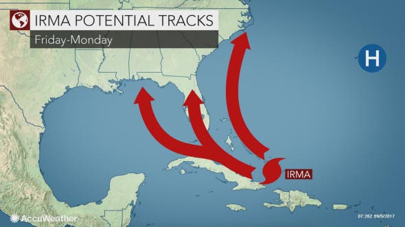
If the storm takes a more southern route, which is the more likely scenario at this point, South Florida would start to be buffeted by Irma's rain and wind as early as this weekend, according to AccuWeather.
If the storm tracks more to the south and west, the Florida Panhandle would be in danger of a direct strike early next week, according to AccuWeather.
Another scenario still on the table is that Irma will curves northward and miss the East Coast entirely. This would still generate large surf and rip currents along the East Coast and off New Jersey, according to AccuWeather. However, this scenario is the least likely to occur at this point.
Another storm could pose a greater threat to the region:
Easy to get focused on #Irma, but tropics remain active. #Jose has now formed further east in the Tropical Atlantic. https://t.co/RdFw2IZ3GA
— Gary Szatkowski (@GarySzatkowski) September 5, 2017
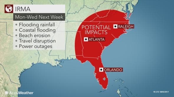
On Tuesday morning, meanwhile, the hurricane center said there is an "increasing chance" that Irma will impact the Florida peninsula and the Florida keys. After that, the unpredictable nature of hurricanes makes an exact forecast difficult.
"(I)t is still too early to determine what direct impacts Irma might have on the continental United States," the hurricane center said in an 8 a.m. post. "However, everyone in hurricane-prone areas should ensure that they have their hurricane plan in place."
8 am Special Advisory: #Irma is now a category 5 #hurricane with maximum sustained winds of 175 mph (280 km/h) More: https://t.co/tW4KeGdBFb pic.twitter.com/QU1LWq7QsA
— NHC Atlantic Ops (@NHC_Atlantic) September 5, 2017
As of 8 a.m. Tuesday, Irma was located about 270 miles east of Antigua. She was moving west at 14 mph.
Forecasters say hurricane warnings have gone up for Antigua, Barbuda, Anguilla, St. Kitts, the British and U.S. Virgin Islands, Puerto Rico and other nearby islands.
A hurricane watch has been issued for Guadeloupe and the Dominican Republic, among other interests in the region. Hurricane warnings mean that hurricane conditions are expected within the warning area within 36 hours. Watches mean conditions are possible.
Tuesday morning, hurricane-force winds extended out from Irma by 45 miles from the center. Tropical storm-force winds were extending outward by 140 miles.

Irma formed during the peak of the 2017 hurricane season. Forecasters call the period between mid-August and mid-October the “season within the season.” This eight-week period “is often the most active and dangerous time for tropical cyclone activity,” according to NOAA.
The peak period is historically responsible for major spikes in tropical weather activity, NOAA said. In fact, it accounts for roughly 78 percent of all tropical storm days on record. It is also the period when 87 percent of the category 1 and 2 hurricane days on record occurred. In addition, this period is responsible for “a whopping 96 percent of the major (category 3, 4 and 5) hurricane days.”
The conditions gradually become less ripe for development in mid-October when increased wind shear tends to reappear and water and air temperatures cool.
The Atlantic hurricane season runs from June 1 to Nov. 30 each year. Average seasons produce about 12 named storms, of which six become hurricanes. Three of the hurricanes are generally deemed major.
Residents readying for the ongoing season can get tips and advice on the federal government’s Ready.gov website.
Get more local news delivered straight to your inbox. Sign up for free Patch newsletters and alerts.