Weather
Flash Flooding, Heavy Rains Possible In North Jersey Today
The National Weather Service says there is a risk of heavy rainfall in North Jersey. With that could come more flooding, and damaging winds.

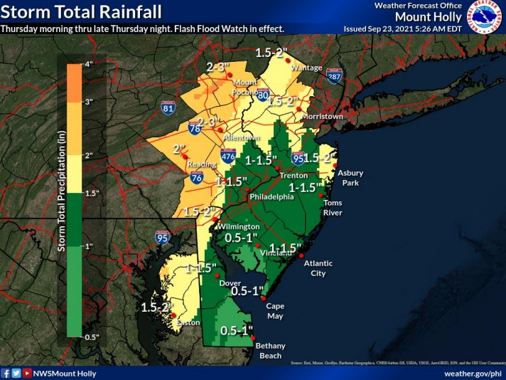
NEW JERSEY — A possibility of severe storms could bring flash flooding and strong, damaging winds to North Jersey. The National Weather Service projects 1 to 3 inches of rain across the region, but said local rainfall totals could climb to 5 inches on Thursday and Friday.
The National Weather Service's Mount Holly office said flash flooding is possible, particularly along, and north and west of, the I-95 corridor.
A flash flood watch remains in effect for northern and central New Jersey from 5 p.m. Thursday to 8 a.m. on Friday for Hunterdon, Middlesex, Morris, Somerset, Sussex and Warren Counties.
Find out what's happening in Waynefor free with the latest updates from Patch.
The National Weather Service's New York, New York office, which covers Bergen, Essex, Hudson, Passaic and Union Counties, has also issued a flash flood watch from 4 p.m. Thursday to 8 a.m. on Friday.
The most likely sources of flooding are creeks, streams, urban areas and poor drainage areas, according to the National Weather Agency. Localized flash flooding is also possible. The flooding would most likely occur Thursday afternoon through Friday morning.
Find out what's happening in Waynefor free with the latest updates from Patch.
Forecasters expect widespread showers and thunderstorms Wednesday from the Great Lakes to the central Gulf Coast before it moves into the Mid-Atlantic. The storm will continue to move east and bring heavy rains to New Jersey.
According to the New York office, the highest chance of thunderstorms will be Thursday night into Friday morning, which could bring wind gusts in excess of 58 mph.
The office added that "an isolated tornado can not be ruled out tonight into early Friday."
For northeast New Jersey, the heaviest rain is expected from around 5 to 7 p.m. on Thursday, through around 1 to 3 a.m. on Friday. Officials from the New York office said there is some uncertainty about how quickly a cold front — the cause for the storms — will move across the area, meaning projections could be "off by 1-2 hours on start and end time."
Here's the forecast through Friday night, as of 10:15 a.m. on Thursday:
Today: Showers, mainly after noon. The rain could be heavy at times. Temperature falling to around 76 by 4pm. South southeast wind between 11 and 15 mph, with gusts as high as 26 mph. Chance of precipitation is 80 percent.
Tonight: Showers and possibly a thunderstorm. Some of the storms could produce gusty winds and heavy rain. Low around 62. Southeast wind 5 to 9 mph becoming west. Winds could gust as high as 22 mph. Chance of precipitation is 100 percent.
Friday: Showers likely, mainly before 9 a.m. Cloudy through mid-morning, then gradual clearing, with a high near 74. West wind around 6 mph. Chance of precipitation is 60 percent.
Friday Night: Mostly clear, with a low around 56. West northwest wind between 3 and 7 mph.
Keep up to date with what's happening in your community by subscribing to your local Patch newsletter here.
Get more local news delivered straight to your inbox. Sign up for free Patch newsletters and alerts.