Crime & Safety
WEATHER ALERT: Hazardous Weather Warning For New Jersey On Friday, Weekend
The National Weather Service issued a "Hazardous Weather Outlook," saying a wintry mix of drenching rain and some snow could come to N.J.

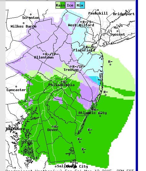


National Weather Service photos: Friday at 8 p.m.; Saturday at 2 p.m.; and Sunday at 8 a.m.
Just when you thought it may be safe to back on the roads....
Enjoy the nice weather this week, where some parts of New Jersey and Pennsylvania will see temperatures rise as high as 60 on Wednesday.
Find out what's happening in Waynefor free with the latest updates from Patch.
The National Weather Service has issued a Hazardous Weather Outlook, saying that “wintry precipitation” is expected to fall on Friday and Saturday, and could make a mess of the Friday afternoon and evening commute (see photos).
Snow could accumulate on roads in parts of New Jersey and slippery spots can occur as far south as the mid-Atlantic, according to AccuWeather.
Find out what's happening in Waynefor free with the latest updates from Patch.
A few areas of black ice can form in parts of northeastern Pennsylvania and northern New Jersey as rain arrives Friday night. These icy areas will not be widespread, but will be most common on bridges and overpasses, according to the report.
Mild air will flow northward with the storm to switch any ice over to rain in the mid-Atlantic by Saturday midday, according to the report.
Subscribe to the Patch free daily newsletter for more local news, and breaking news alerts delivered to your inbox, by clicking here.
Other Patch stories:
- Former Superintendent Convicted After Taking $60,000, Falsifying Records
- Manholes Explode During Rush Hour In Montclair And Verona
- UPDATE: Death Near NJ Transit Train Tracks In Point Beach
- Ocean County Man Tells Gov. Christie In Iowa He Will ‘Not Sit Down and Shut Up’ About Hurricane Sandy
- You Again? Man Gets Parole, Robs Same Toms River Store That Got Him Jailed In 1999
Get more local news delivered straight to your inbox. Sign up for free Patch newsletters and alerts.