Community Corner
Weather Update: Sun's Out, Snow's Melting But We're In for More Frigid Weather
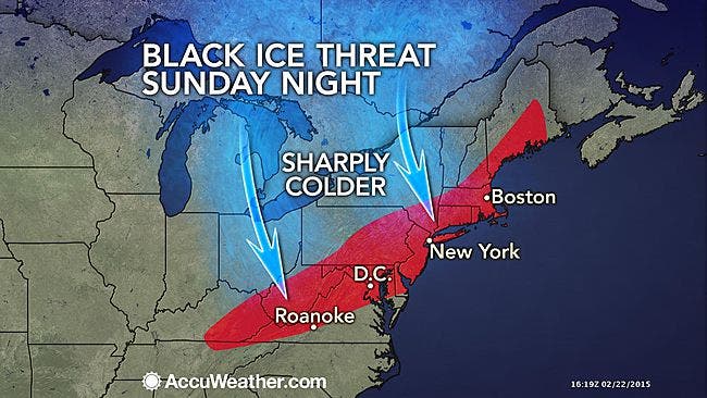
Monday morning's commute could be an icy mess in and around Bronxville, Tuckahoe and Eastchester.

Written by Brian McCready (Patch Staff)
Today’s story is one of good news for about 12 hours.
The snow has ended, temperatures are above the freezing mark for the first time in seemingly ages, and we could exceed 40 degrees in parts of the Hudson Valley.
Find out what's happening in Bronxville-Eastchesterfor free with the latest updates from Patch.
In fact, we might not see any more snow until next weekend as only a slight chance of snow appears on the horizon on Tuesday or Wednesday.
But that’s the end of the good news. What goes up, inevitably goes down, and that is what will happen to temperatures beginning tonight.
Find out what's happening in Bronxville-Eastchesterfor free with the latest updates from Patch.
Temperatures will free-fall Sunday night all the way down to the single digits in some parts of the region, which means whatever snow melts today will freeze and make for an icy Monday morning commute back to work and school.
“When the arctic air arrives, untreated roads, sidewalks, overpasses and bridges will have the opportunity to freeze up,” said AccuWeather.com Meteorologist Tyler Roys.
Monday’s forecast calls for some sun but temperatures in the low teens, with wind chills below zero. Wind gusts could approach 30 miles per hour. Monday night temperatures will again hover around zero and below, and wind chills will take it down to close to minus-10 degrees in some parts of the region.
Tuesday looks like it could be a close repeat of Monday, but with a slight chance of snow Tuesday night.
Below are snow totals for Saturday night and Sunday morning in Westchester County, according to the National Weather Service:
HARTSDALE 6.2 815 AM 2/22
SCARSDALE 6.2 857 AM 2/22
EASTCHESTER 6.1 830 AM 2/22
DOBBS FERRY 6.1 815 AM 2/22
WHITE PLAINS 6.0 825 AM 2/22
HARRISON 6.0 800 AM 2/22
ARMONK 5.5 820 AM 2/22
MOUNT KISCO 5.4 700 AM 2/22
SOMERS 4.8 1200 AM 2/22
YONKERS 4.0 755 AM 2/22
NORTH SALEM 3.8 1020 PM 2/21
PELHAM 2.9 830 PM 2/21
Patch Editor Alfred Branch contributed to this report.
Image via AccuWeather.com
Subscribe to a free email newsletter and news alerts:
BEDFORD-KATONAH • BRONXVILLE-EASTCHESTER-TUCKAHOE • CHAPPAQUA-MOUNT KISCO • HARRISON • LARCHMONT-MAMARONECK • NANUET • NEW CITY • NEW ROCHELLE • NYACK-PIERMONT • OSSINING-CROTON • PEARL RIVER • PEEKSKILL-CORTLANDT • PELHAM • PORT CHESTER • PLEASANTVILLE-BRIARCLIFF • RIVERTOWNS • RYE • SCARSDALE • SOUTHEST-BREWSTER • TARRYTOWN-SLEEPY HOLLOW • WHITE PLAINS • YORKTOWN-SOMERS
Get more local news delivered straight to your inbox. Sign up for free Patch newsletters and alerts.