Community Corner
The Coming Storm: When and How Much?
Forecast models disagree on how close the storm will come to the New York coast.


The National Weather Service continues to post a Hazardous Weather Outlook for Putnam, Rockland and Westchester counties.
The NWS still says the storm will pass to the south and east of Long Island. Today, however, its meteorologists have lowered their estimates of snowfall to 2-5 inches.They’re also calling for up to a tenth of an inch of ice. “Stay tuned, the NWS says, as there is still some uncertainty with the precipitation types and amounts, due to the storm track and intensity.”
Hudson Valley Weather said that two of the most-used computer models still disagree on the storm’s track.
Find out what's happening in Chappaqua-Mount Kiscofor free with the latest updates from Patch.
“The trend is bringing this storm system closer to the coast, and pulling the snow band further into the Hudson Valley,” its meteorologists wrote Thursday night. “We are concerned that we could be looking at a significant event for Saturday… but we’ll continue to track it closely. The storm is going to form… the key is ’location, location, location.’ Exactly where this storm tracks… will mean the difference between 1 to 3 inches… and possibly over 6″.”
Here’s the NWS forecast for northern Westchester:
Find out what's happening in Chappaqua-Mount Kiscofor free with the latest updates from Patch.
- Friday—Sunny. Highs in the mid 30s. Southwest winds around 5 mph.
- Friday Night—Partly cloudy in the evening...then mostly cloudy with a chance of snow after midnight. Lows in the lower 20s. West winds around 5 mph. Chance of snow 50 percent.
- Saturday—Snow and freezing rain in the morning...then snow... Freezing rain and sleet with rain likely in the afternoon. Moderate snow accumulation. Highs in the lower 30s. North winds 10 to 15 mph with gusts up to 25 mph. Chance of precipitation 90 percent.
- Saturday Night—Mostly cloudy. A slight chance of snow in the evening. Lows in the mid 20s. Northwest winds 10 to 15 mph. Gusts up to 25 mph in the evening. Chance of snow 20 percent.
- Sunday—Partly sunny. Highs in the mid 30s.
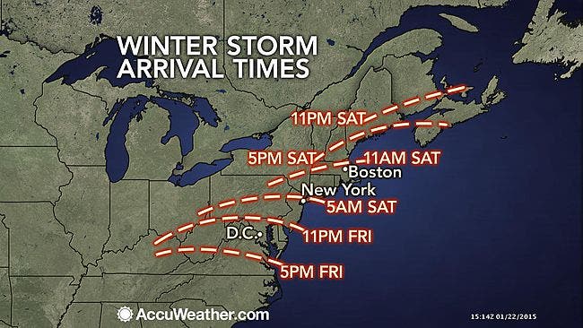
Snow, rain, ice—the storm will affect most of the northeast I-95 corridor, making travel tricky.
“Where the snow is heavy and wet, there could be trees coming down with power outages,” said AccuWeather.com Chief Meteorologist Elliot Abrams.
MAP: accuweather.com
» News Alerts: Subscribe to a free email newsletter:
BEDFORD-KATONAH • BRONXVILLE-EASTCHESTER-TUCKAHOE • CHAPPAQUA-MOUNT KISCO • HARRISON • LARCHMONT-MAMARONECK • NANUET • NEW CITY • NEW ROCHELLE • NYACK-PIERMONT • OSSINING-CROTON • PEARL RIVER • PEEKSKILL-CORTLANDT • PELHAM • PORT CHESTER • PLEASANTVILLE-BRIARCLIFF • RIVERTOWNS • RYE • SCARSDALE • SOUTHEST-BREWSTER • TARRYTOWN-SLEEPY HOLLOW • WHITE PLAINS • YORKTOWN-SOMERS
Get more local news delivered straight to your inbox. Sign up for free Patch newsletters and alerts.