Community Corner
WEATHER ALERT: More Snow Forecast for Mount Kisco, Chappaqua on Thursday
Local meteorologists predict we may be shoveling by Friday morning.


Not again!
There is another chance for accumulating snow in the near future as a winter storm could dump up to six inches of snow on the Hudson Valley on Thursday, but the confidence in that prediction currently is low, according to local meteorologists.
Here’s what we currently know about the latest threat.
Find out what's happening in Chappaqua-Mount Kiscofor free with the latest updates from Patch.
“Let’s start with the certain, there is some impressively cold air headed our way,” say the meteorologists at Hudson Valley Weather. “Now let’s talk about the snow potential that exists, this is where things become a lot more uncertain. We have fairly high confidence that a clipper system will spread some light snow into our region between Wednesday night into Thursday.”
And here’s what accuweather.com has to say:
Find out what's happening in Chappaqua-Mount Kiscofor free with the latest updates from Patch.
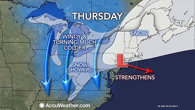
“There is also the potential for the storm to strengthen as it moves near the Atlantic Ocean. In this scenario, a swath of moderate to heavy snow could develop in part of the coastal Northeast,” writes Alex Sosnowski, AccuWeather.com Senior Meteorologist. “During the day Thursday, spotty snow is likely to impact Philadelphia; New York City; Albany, New York; and Hartford, Connecticut. It is from late Thursday into Friday morning when the storm could strengthen quickly enough to bring steadier and perhaps heavier snow from part of New Jersey and eastern New York state to Massachusetts and coastal Maine.”
And after the latest snow chance, it’s going to get cold, really cold—so cold that de-icing compounds won’t work. And another round of snow is possible this weekend.
Just a reminder, 38 days from now until spring.
And here is what the National Weather Service is predicting for northern Westchester County in its latest hyperlocal forecast for Thursday’s snow chance.
- Today--Partly sunny. Highs in the lower 30s. North winds 10 to 15 mph with gusts up to 25 mph.
- Tonight--Partly cloudy in the evening...then becoming mostly clear. Lows around 14. Northeast winds 5 to 10 mph with gusts up to 20 mph.
- Wednesday--Mostly sunny. Cold with highs in the upper 20s. Northeast winds 5 to 10 mph with gusts up to 20 mph.
- Wednesday Night--Mostly cloudy. A slight chance of snow after midnight. Lows around 15. East winds around 5 mph in the evening... Becoming light and variable. Chance of snow 20 percent.
- Thursday--Snow. Light snow accumulation. Cold with highs in the upper 20s. Southeast winds around 5 mph. Chance of snow 80 percent.
- Thursday Night--Mostly cloudy. Snow likely in the evening. Additional light snow accumulation possible. Brisk and cold with lows around 10 above. Chance of snow 60 percent. Wind chill values as low as 5 below after midnight.
MAP: accuweather.com
» News Alerts: Subscribe to a free email newsletter:
BEDFORD-KATONAH • BRONXVILLE-EASTCHESTER-TUCKAHOE • CHAPPAQUA-MOUNT KISCO • HARRISON • LARCHMONT-MAMARONECK • NANUET • NEW CITY • NEW ROCHELLE • NYACK-PIERMONT • OSSINING-CROTON-ON-HUDSON • PEARL RIVER •PEEKSKILL-CORTLANDT • PELHAM • PORT CHESTER • PLEASANTVILLE-BRIARCLIFF MANOR • RIVERTOWNS • RYE • SCARSDALE • SOUTHEAST-BREWSTER • TARRYTOWN-SLEEPY HOLLOW • WHITE PLAINS • YORKTOWN-SOMERS
Get more local news delivered straight to your inbox. Sign up for free Patch newsletters and alerts.