Crime & Safety
Flood Watch Issued For Long Island
BREAKING: Tuesday's rain was just a preview of a bigger storm coming our way.

The National Weather Service has issued a flood watch for Long Island as a storm system packing heavy rain and gusty winds takes aim at the region.
The flood watch will be in effect from 8 a.m. Thursday until 2 p.m. Friday.
First up, we get a gorgeous Wednesday with mostly sunny skies and highs in the upper 50s. The rain moves in Thursday morning.
Find out what's happening in Medfordfor free with the latest updates from Patch.
The rain may be heavy at times, especially during the afternoon. There's also a chance of thunderstorms Thursday afternoon.
Up to 2 inches of rain, with locally higher amounts possible in areas that see thunderstorms, is likely to fall.
Find out what's happening in Medfordfor free with the latest updates from Patch.
A flood watch means there is a potential for flooding based on current forecasts. You should monitor later forecasts and be alert for possible flood warnings. Those living in areas prone to flooding should be prepared to take action should flooding develop.
"The storm has the potential to be the strongest in a series to hit the Northeast since late March and through the first week of April," AccuWeather Senior Meteorologist Brett Anderson said.
By Thursday evening, the heaviest precipitation moves eastward, though the potential for spotty rain showers will continue through Saturday night, the NWS says.
High pressure builds beginning Sunday into early next week, with mild, above-normal temperatures.
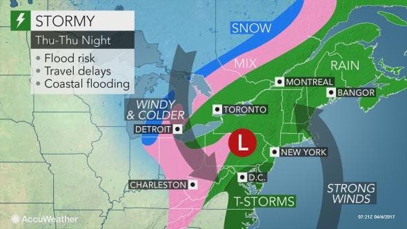
Photo: AccuWeather
Get more local news delivered straight to your inbox. Sign up for free Patch newsletters and alerts.