Community Corner
WEATHER UPDATE: Snow, Sleet Could Cause Morning Mess
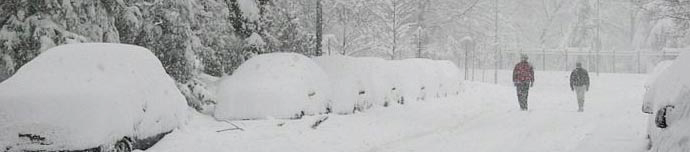
Plus freezing rain and then arctic temperatures—this storm could make Monday and even Tuesday morning tricky for commuters.

The National Weather Service’s winter storm warning is in effect until Monday at 6 p.m.
Snow accumulations could reach 13 inches in Putnam, less in Northern Westchester, and still less in Rockland and Southern Westchester counties.
Additionally, the forecast calls for sleet and freezing rain, which could leave a quarter of ice on top.
Find out what's happening in Nanuetfor free with the latest updates from Patch.
Here’s the storm timeline forecast by Hudson Valley Weather:
- Snow begins Sunday, between 6pm and 10pm from southwest to northeast.
- Snow could fall heavy at times (1 to 2 inches per hour) between 2am and 10am Monday
- Snow will likely mix with sleet and freezing rain for a time during the morning, near and south of I-287.
- Snow tapers off between 3pm and 6pm Monday evening
What’s more, arctic air is coming in right behind this storm—plummeting temperatures could make roads and sidewalks hard to clear and even have some effect on the Tuesday morning commute.
Find out what's happening in Nanuetfor free with the latest updates from Patch.
SEE ALSO:
Get more local news delivered straight to your inbox. Sign up for free Patch newsletters and alerts.