Weather
Bomb Cyclone To Bring Wild Weather To The Hudson Valley
The storm could create an unpleasant evening commute Wednesday and lead to power outages as winds intensify overnight. Here's the latest.


A 'bomb cyclone' is headed into the Hudson Valley, first bringing drenching rains and then high, gusty winds to the tri-state area. The National Weather Service issued a hazardous outlook for Dutchess and Ulster counties. Flooding, with inundation of 1 to 2 feet above ground in vulnerable coastal areas, is possible in southern Westchester.
"A very winter like system will take aim on the Hudson Valley Wednesday afternoon and night," said Alex Marra and Bill Potter of Hudson Valley Weather, "before slowly exiting on Thursday."
Two low pressure systems, one inland and one off the coast, will create the condition called bombogenesis.
Find out what's happening in New Cityfor free with the latest updates from Patch.
"The latest indications are the storm will strengthen at a fast enough pace from Wednesday to Thursday to be classified as a bomb cyclone," said Alex Sosnowski, AccuWeather senior meteorologist. "The barometric pressure has to fall at least 24 millibars, or 0.71 inches, in 24 hours for the bomb cyclone criteria to be met."
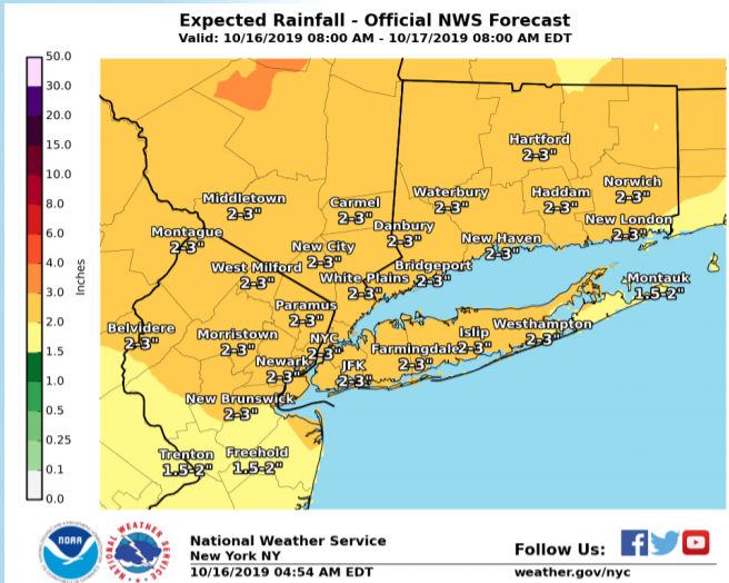
The big coastal storm will bring rainfall of 2-3 inches, with up to 4 inches possible in the mid-Hudson. Thunderstorms are also possible.
Find out what's happening in New Cityfor free with the latest updates from Patch.
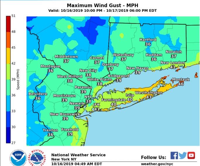
Winds gusting over 40 mph, and shifting from the northeast to the northwest, will at the least shake leaves off trees and possibly lead to some power outages.
For the mid-Hudson Valley, the National Weather Service said:
A widespread soaking rainfall of two to four inches is likely this afternoon into Thursday with brisk winds. The rainfall may become locally heavy which may yield some poor drainage flooding of low lying areas, and ponding of water on roadways. Leaves, twigs, trash and other debris could clog some drains and produce some nuisance flooding. If confidence increases for the potential of widespread flooding, then a flood watch may be issued later today. Southeast winds could gust 35 to 45 mph tonight before shifting to the northwest.
The strongest winds will be late Wednesday through Thursday, the NWS predicted.
The weather could make for a particularly unpleasant evening commute Wednesday. Remember, wet pavement can make for especially slick conditions on secondary roads.
Check back with Patch for more about the approaching storm.
.gif)
Get more local news delivered straight to your inbox. Sign up for free Patch newsletters and alerts.