Weather
Hazardous Weather Outlook For Hudson Valley Weekend
Here are the details for this weekend and an early forecast for the Fourth.

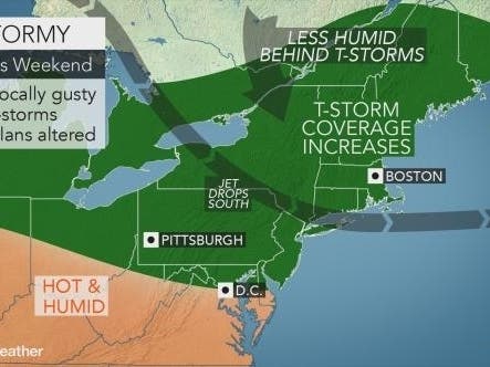
HUDSON VALLEY, NY — It'll be hot and humid Thursday and Friday. Starting Friday, the National Weather Service has issued a hazardous weather outlook for Orange, Putnam, Rockland and Westchester counties.
First, it'll get hot. The mercury will rise well into the 80s today, and into the 90s away from the south coasts of Long Island and southern Connecticut, the National Weather Service predicted.
Plus air quality will begin to degrade. The air quality index is Moderate for Rockland and Westchester counties and Good for the rest of the lower and mid-Hudson Valley. Air quality is Poor on Long Island and an Advisory has been issued.
Find out what's happening in New Cityfor free with the latest updates from Patch.
For Friday, similar afternoon high temperatures are forecast. Then the weather will become unsettled. A cold front will approach the region from the northwest on Saturday. This will lead to an increase in humidity.
Friday through Wednesday, scattered severe thunderstorms are possible ahead of that cold front.
Find out what's happening in New Cityfor free with the latest updates from Patch.
"The primary threats are large hail and damaging winds," the National Weather Service warned.
After that, temperatures will trend upward in the Hudson Valley for the July 4th weekend.
Get more local news delivered straight to your inbox. Sign up for free Patch newsletters and alerts.