Weather
Hudson Valley Storm: Snow Totals, Monday Evening Forecast
Don't relax yet. Here's the latest from the National Weather Service.

UPDATE TUESDAY SEE: Interim Snow Totals For Hudson Valley: National Weather Service
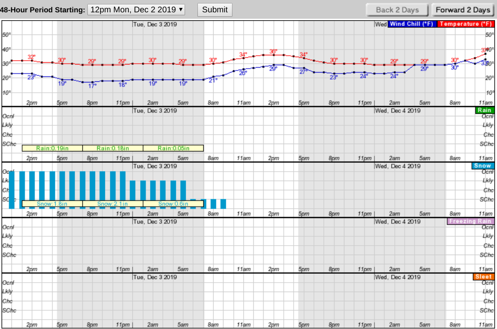
UPDATE 6:30 p.m. — The storm system will continue to bring periods of snow to the Mid Hudson Valley. The National Weather Service predicts heavy snowfall amounts for most of the forecast area by the time snow tapers off by around daybreak Tuesday. The NWS says:
Precipitation will change to all snow for the majority of the forecast area as the night progresses. The snow could come down moderate to briefly heavy at times. 3 to 6 inches are expected for New York City and the surrounding metro area, and 6 to 8 inches across portions of northeastern New Jersey and the Lower Hudson Valley into southwestern Connecticut.
Want an idea of just how variable this storm has been so far? The NWS offered a glimpse, posting interim snow totals that came in between 12:30 p.m. and 4:30 p.m. Monday for Orange and Westchester counties:
Find out what's happening in New Cityfor free with the latest updates from Patch.
Orange County
- MIDDLETOWN: 8.0 inches by 2:15 p.m.
- MONROE: 6.3 inches by 2:40 p.m.
Westchester County
Find out what's happening in New Cityfor free with the latest updates from Patch.
- WINDMILL FARM in Armonk: 1.5 inches by 1:55 p.m.
Improving conditions are forecast for Tuesday with continued cold temperatures. An upper level disturbance will bring some snow showers Wednesday into Thursday, the NWS said.
UPDATE 3 p.m. — There are severe snow and ice conditions on roads across the Hudson Valley, according to 511NY.
Due to the winter weather 45mph advisories are in place on the following:
- All parkways in the lower Hudson Valley
- Route 17: Binghamton to I-84
- I-84: Entire length
- I-684: Entire length
The New York State Thruway has a 45mph restriction in place:
- I-87 (Thruway) between Exit 15 and Exit 18
Traffic conditions have deteriorated and roads are expected to continue to get worse, especially in Northern NJ. We can't stress this enough - leave yourself extra time and travel carefully this afternoon and evening. #nycstorm #njwx pic.twitter.com/yBMmnbV7ST
— New York Metro Weather (@nymetrowx) December 2, 2019
Metro-North reports that the Harlem and New Haven lines are on or close to schedule. Trains on the Hudson Line are running 10-15 minutes behind schedule.
Please help us by clearing out your fire hydrants! This could save us valuable time at a house fire....if it snows https://t.co/k9kiyPqODj pic.twitter.com/nUeMqDltmb
— Kempter's Fire Wire (@KempterFireWire) December 2, 2019
UPDATE 11:30 a.m. — Bands of heavy snow circling the Hudson Valley are expected to taper off starting at midnight on Monday. They may mostly affect communities west of the river, the National Weather Service said. Still, across the region, the NWS warns of snow- and ice-covered roads resulting in dangerous travel, potential snowfall bursts of 1 to 2 inches an hour, and possible downed tree limbs and power outages. SEE: 500 Customers Out Of Power In Putnam County: Hudson Valley Storm.
While some snow may fall until dawn Tuesday, dry and cool conditions are expected for the rest of the day and Wednesday. Temperatures will remain mostly below normal.
See the 6:30 a.m. update, below, for county-by-county predictions.
"There will be very sharp cutoffs between an additional 6 to 12 inches of snow… and an additional 1 to 3 inches," Alex Marra and Bill Potter of Hudson Valley Weather said Monday morning. "That is appearing more and more likely to occur within the Hudson Valley."
New York state officials declared a State of Emergency in Albany, Columbia, Greene, Rensselaer, Schenectady, Saratoga and Ulster counties. New Yorkers planning to travel Monday and Tuesday morning are being urged to continue using extreme caution.
The Governor Mario M. Cuomo Bridge currently has an advised speed limit of 35 miles per hour and an advised speed limit of 45 miles per hour remains in effect on the following roads:
- All State owned Parkways in DOT Region 8 (Hudson Valley)
- I-81: PA line to Syracuse
- Route 17: Binghamton to I-84
- I-84: Entire length
- I-86: from PA line to Binghamton
- I-88: Binghamton to I-90
- I-99: Entire length
- I-684: Entire length
- I-90: exit 41 to exit 24 (Albany)
- I-87: from exit 24 to exit 15 including the Berkshire spur. The speed restriction in place on the NYS Thruway between exit 29 (Canajoharie) to exit 15 (NJ I-287) including the Berkshire Spur.
Here is the hourly forecast for Rockland County from the National Weather Service:
The Red Cross has tips for shoveling heavy, wet snow:
- Stretch before you go out. If you go out to shovel snow, do a few stretching exercises to warm up your body. This will reduce your chances of muscle injury.
- Avoid overexertion. Heart attacks from shoveling heavy snow are a leading cause of death during the winter.
- Walk carefully. Slips and falls occur frequently in winter weather, resulting in painful and sometimes disabling injuries.
SEE ALSO: Brewster Closes Court, Cancels Meeting
UPDATE 7:30 a.m. — HudsonLink messaged riders to expect delays on all routes Monday morning to due weather conditions. Check www.ridehudsonlink.com for more information. TRIPS paratransit buses have a delayed opening at 9 AM.
Please Use Cautionpic.twitter.com/DwziQqTPnF
— Metro-North Railroad (@MetroNorth) December 2, 2019
UPDATE 6:30 a.m. — Snow is expected to begin falling again Monday morning. Districts across the region closed, delayed or announced early dismissal. SEE: Monday School Snow Schedule Changes Updated For Hudson Valley.
The National Weather Service predictions:
- Southern Westchester: rain turning to snow Monday afternoon, with snow accumulation around an inch. Snow Monday night into Tuesday morning could add another 2 to 4 inches.
- Rockland County: Snow. Rain and freezing rain this morning, then rain this afternoon. Snow accumulation of 2 to 4 inches. Ice accumulation around a trace. Tonight: Snow. Total snow accumulation of 4 to 8 inches.
- Northern Westchester: Freezing rain this morning. Rain and snow. Snow accumulation of 1 to 3 inches. Ice accumulation around a trace. Tonight: Snow. Total snow accumulation of 4 to 6 inches.
- Putnam County: Rain, sleet and freezing rain this morning. Snow. Snow and sleet accumulation of 3 to 5 inches. Ice accumulation of up to a tenth of an inch. Tonight: Snow. Total snow accumulation of 4 to 8 inches.
- Dutchess County: Periods of rain or snow this morning, then periods of snow this afternoon. Additional snow accumulation of 1 to 3 inches. Tonight: Periods of snow. Snow may be heavy at times in the evening. Total snow accumulation of 4 to 8 inches.
- Orange County: Freezing rain, sleet and rain this morning. Snow. Additional snow and sleet accumulation of 4 to 6 inches. Ice accumulation of up to a tenth of an inch. Tonight: Snow, mainly in the evening. Total snow accumulation of 6 to 10 inches.
- Eastern Ulster County: Periods of snow. Additional snow accumulation of 2 to 4 inches. Tonight: Periods of snow. Snow may be heavy at times in the evening. Total snow accumulation of 6 to 10 inches.
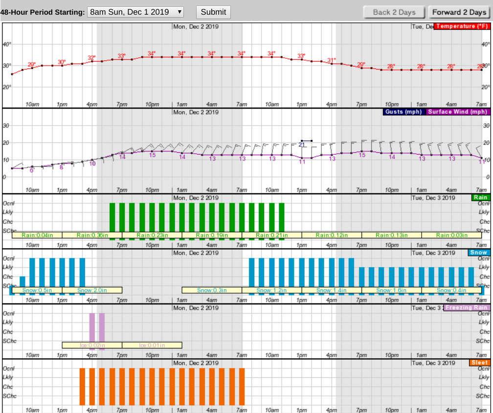
Here is the National Weather Service's hourly weather report for northern Westchester for the next 48 hours:
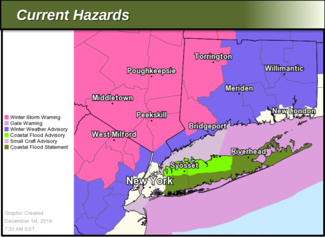
UPDATE 10:30 p.m. — The National Weather Service adjusted its snow accumulation estimates for the lower Hudson Valley in its Sunday evening briefing. Meanwhile, winds will be gustier. The NWS has issued a Gale Warning for all waters Sunday night into Monday afternoon.
Also the Coastal Flood Advisories have been expanded across coastal areas adjacent to the western end of the Long Island Sound for Sunday night.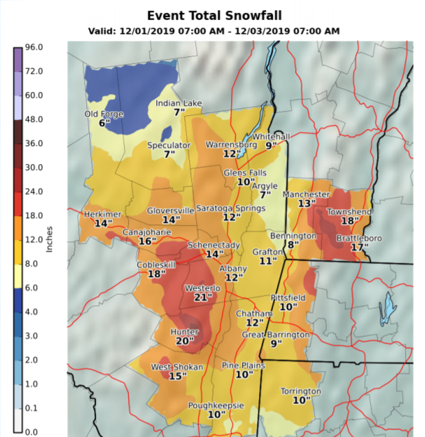

Snow returns to the area by Monday, starting midday north and west of the metro area, the NWS said Sunday evening. The heaviest snow is expected across the interior with less snow towards the coastline. The snow begins to taper northwest to southeast by early Tuesday morning.
Monday's part of the storm will come in bands of heavy snow, so some parts of the Hudson Valley could see more or less snow than the overall estimate.
UPDATE 7 p.m. — School districts in the mid-Hudson Valley have begun announcing schedule changes in light of the forecast for more snow on Monday.
SEE: Snow Delay, Closings Announced In Hudson Valley: Update
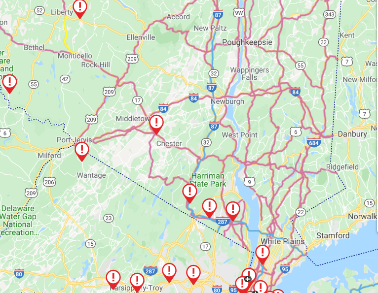
Travel is difficult. Note all the recent incidents reported in the Hudson Valley by the New York State Thruway.
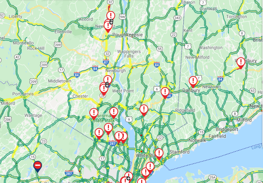
UPDATE 3:20 p.m. — Roads have become treacherous across the region. Bus service has been cancelled out of Port Authority in New York City to Binghamton, Rochester, Buffalo, Ithaca and Syracuse until further notice. The Thruway Authority has lowered the speed limit on the Gov. Mario Cuomo Bridge to 35 mph.
A crash on I-87 - NYS Thruway southbound between Exit 14B (I-87) - Airmont Rd and Spring Valley Toll Barrier is affecting traffic, 511NY reported at 3:13 p.m.
Mid-Hudson Region Weather Conditions for Hudson River Bridges at 1515: Bear Mountain Bridge: Flurries, traffic is light. Newburgh Beacon Bridge: Flurries, traffic is moderate. Mid-Hudson Bridge: Flurries, traffic is light There active plows and sanders all bridges
— NYS Bridge Authority (@NYSBridge) December 1, 2019
Kingston-Rhinecliff Bridge: Light snow, traffic is light. Rip-Van Winkle Bridge:Flurries. Traffic is light. Active Plows and sanders at all Bridges.
— NYS Bridge Authority (@NYSBridge) December 1, 2019
8 a.m. — The National Weather Service has upgraded its predictions for the winter storm bearing down on the region. The NWS issued a warning for all of the lower and mid Hudson Valley except southern Westchester. There's also a gale watch for eastern Long Island Sound.
The storm will make travel treacherous and could also lead to power outages and school cancellations and delays.
"As we turn the calendar to December, we’ll kick off the 19/20 winter season with a bang," said Alex Marra and Bill Potter of Hudson Valley Weather. "The complex structure of this storm will also mean some inevitable surprises. "
ALSO SEE:
Pleasantville's Winter Parking Restrictions Now In Effect
Weathering The Hudson Valley's Thanksgiving Weekend Storm: O&R
Remember Snow Parking, Sidewalk Rules In Croton-On-Hudson
The storm has two main stages. Snow started Sunday morning, moving in from west to east. Snow will change to sleet, then to rain at the coast Sunday afternoon into tonight and a wintry mix of sleet and freezing rain north of the coast. Precipitation will taper off and then the second stage of snow will begin Monday morning.
Most snow is expected across the interior with less snow towards the coastline. Some ice accretion is also expected across the interior as freezing rain becomes a part of the wintry mix later today into tonight.
The National Weather Service predicts total snow accumulations of 5 to 12 inches and ice accumulations of up to one quarter of an inch for Orange, Putnam, Rockland and northern Westchester, with 7 to 13 inches and ice accumulations of around one tenth of an inch for Dutchess and Ulster Counties. Southern Westchester could see a total snow accumulations of 2 to 4 inches and ice accumulations of a light glaze.
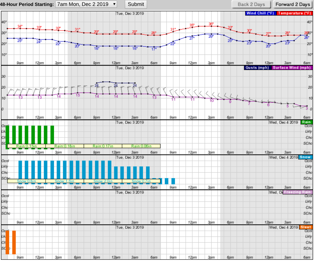
Here's the NWS hourly forecast for the next 48 hours starting 8 a.m. Sunday:
In addition, the storm is predicted to bring inundation of 1 to 1 1/2 ft above ground in vulnerable locales along Western Long Island Sound. Beach erosion and wave splashover are possible.
Power outages and tree damage are likely due to the ice.
Travel could be very difficult. The hazardous conditions could affect holiday travel as well as the morning and evening commute on Monday and possibly the morning commute Tuesday.
If you must travel, keep an extra flashlight, food, and water in your vehicle in case of an emergency. Check local Department of Transportation information services for the latest road conditions.
Get more local news delivered straight to your inbox. Sign up for free Patch newsletters and alerts.