Weather
Final Town-by-Town Snow Totals For Hudson Valley: NWS
The storm dropped more snow overnight on several parts of the Hudson Valley, bringing additional accumulation.

UPDATE — Snow totals for Dutchess and Ulster counties released by the National Weather Service show a range of accumulation in the 36-hour winter storm that kicked off December.
Dutchess County
- RED HOOK - 16.0 inches
- POUGHKEEPSIE - 13
- RHINEBECK - 12.1
- HYDE PARK - 10
- LAGRANGE - 8
- HOPEWELL JUNCTION - 7
- POUGHQUAG - 4
Ulster County
Find out what's happening in Peekskill-Cortlandtfor free with the latest updates from Patch.
- SPENCERTOWN - 22.5
- PHOENICIA - 16
- ULSTER PARK - 12
- ESOPUS - 10.8
UPDATE — The National Weather Service released final snow totals for Orange, Putnam, Rockland and Westchester counties. Snow totals have not been released for Dutchess and Ulster. We do know that in the upper Hudson Valley, this storm was one for the record books, dumping 22.6 inches on Albany.
Orange County
Find out what's happening in Peekskill-Cortlandtfor free with the latest updates from Patch.
- MIDDLETOWN - 13.2 inches
- THOMPSON RIDGE 12.5
- NEWBURGH 11.9
- 3 ESE PORT JERVIS 11.2
- 3 WNW WARWICK 10.8
- 1 NNW CORNWALL ON HUDSON 10.5
- OTISVILLE 10.0
- PINE BUSH 9.5
- MOUNT HOPE 9.5
- GARDNERTOWN 9.1
- 1 N PORT JERVIS 9.0
- WARWICK 9.0
- MONROE 8.7
- MONTGOMERY 8.5
- 3 SW GREENWOOD LAKE 8.1
- PORT JERVIS 8.0
- HAMPTONBURGH 7.0
- NEW WINDSOR 7.0
Putnam County
- 4 miles east-southeast of BEACON - 6.5 inches
- MAHOPAC 4.5
- 4 N CARMEL 4.4
- CARMEL 4.3
- 1 N BREWSTER 3.1
Rockland County
- SLOATSBURG - 5.1 inches
- SPRING VALLEY 4.5
- SUFFERN 4.0
- STONY POINT 2.5
- NYACK 2.0
.WESTCHESTER COUNTY...
- SHRUB OAK - 4.5 inches
- CROTONVILLE 4.4
- ARMONK 4.0
- CHAPPAQUA 3.0
- 1 N SOUTH SALEM 2.4
- 2 NW SOUTH SALEM 1.8
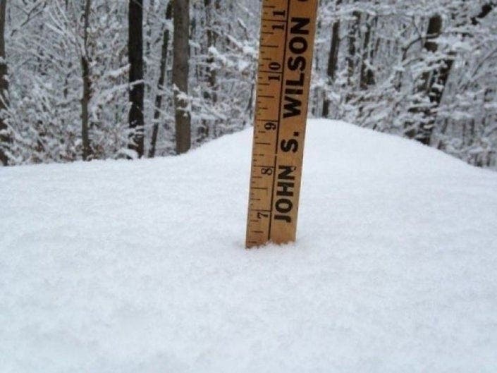
HUDSON VALLEY, NY — The winter storm that started Sunday morning seemed just about over Monday evening, at which point the National Weather Service released snow accumulation measurements from several locations.
Then, of course, the storm dropped several more inches of snow overnight on several parts of the Hudson Valley, bringing additional snow accumulations of 1 to 4 inches. SEE: Hudson Valley Storm: Snow Totals, Monday Evening Forecast
"We emphasized that this storm would have some surprises with it…. well, SURPRISE!!?" said Alex Marra and Bill Potter of Hudson Valley Weather, watching more bands of snow on the radar at 11 p.m. Tuesday and expected to continue into the early morning.
The combination of snow and sleet made compact layers, making measuring difficult.
Potter and Marra finished up with a live-stream commentary at midnight.
Get more local news delivered straight to your inbox. Sign up for free Patch newsletters and alerts.