Weather
First Snow, Ice Estimates: Hudson Valley Storm
The National Weather Service upped its snow and ice accumulation estimates for much of the Hudson Valley Saturday morning.

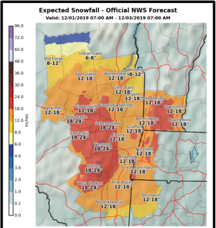
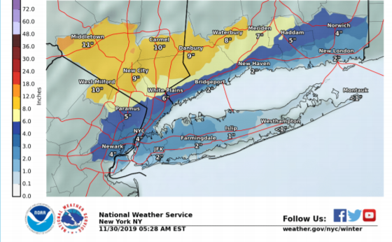
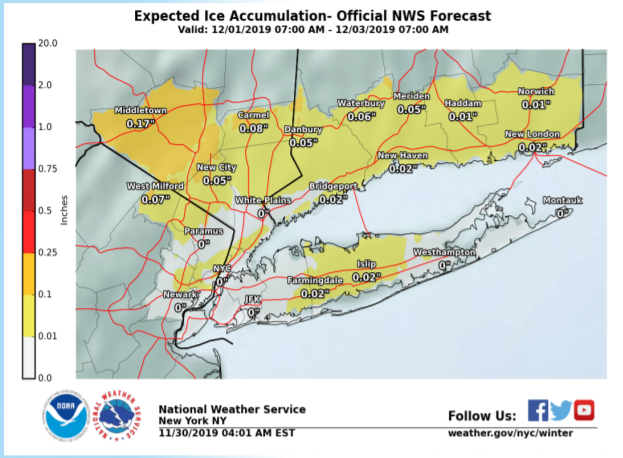
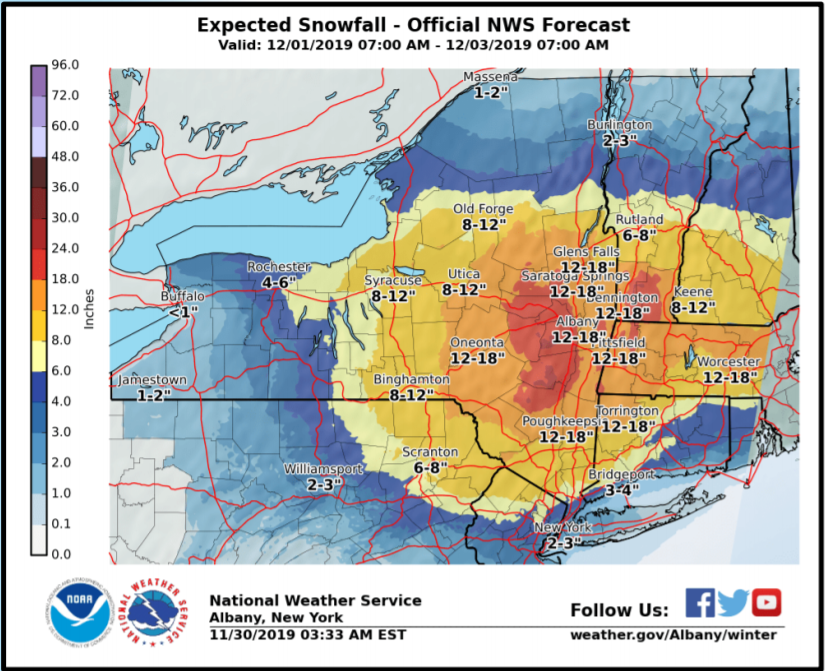
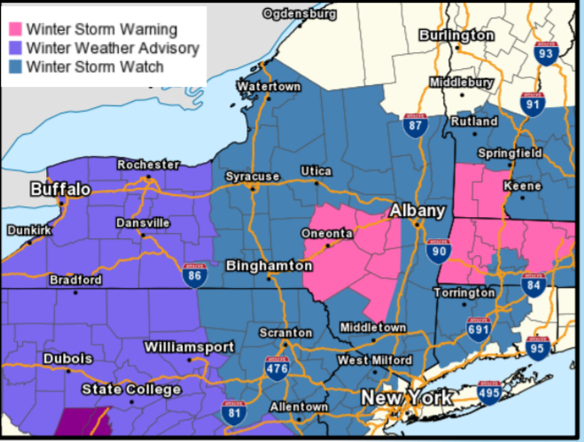
HUDSON VALLEY, NY — Much of the lower Hudson Valley can expect significant snow and ice from the winter storm bearing down on the region to end the Thanksgiving holiday weekend. The National Weather Service has updated its storm report with slightly higher estimates of snow and ice accumulation.
A winter storm watch will be in effect from 7 a.m. Sunday until 7 a.m. Tuesday.
This storm will move from south to north, with snow starting in Putnam, Rockland and southern Westchester counties around 10 a.m. Sunday. It is expected to end around midnight Monday.
Find out what's happening in New Cityfor free with the latest updates from Patch.
As usual the range is large, with snow totals rising inland and up the valley. Six to 18 inches of snow could fall on much of the Hudson Valley between Sunday morning and Monday night.
A lull in the storm should come Sunday afternoon in much of the region. The snow is expected to change temporarily to a wintry mix of sleet, snow and rain in parts of the lower Hudson Valley, forecasters predicted. Then it will change back to snow overnight.
Find out what's happening in New Cityfor free with the latest updates from Patch.
In southern Westchester County, sleet, freezing rain and rain will predominate. Minor coastal flooding is possible in vulnerable areas along the Long Island Sound.
Ice accumulations are expected across the lower Hudson Valley Sunday night to Monday morning.
It will continue to snow through Monday for most of the Hudson Valley. Periods of heavily-falling snow and sleet will cover roads and make traveling hazardous, the NWS said.
If you'll be on the road, here are tips for safe driving:
- Use caution on bridges as ice can form quicker than on roads.
- Wet leaves on roadways can cause slippery conditions, making it important to drive at slower speeds when approaching patches of them.
- Make sure your car is stocked with survival gear like blankets, a shovel, flashlight and extra batteries, extra warm clothing, set of tire chains, battery booster cables, quick energy foods and brightly colored cloth to use as a distress flag.
- If you have a cell phone or other communications device such as a two-way radio available for your use, keep the battery charged and keep it with you whenever traveling. If you should become stranded, you will be able to call for help, advising rescuers of your location.
Less than 24 hours out, there are still uncertainties.
"If the secondary low forms further north the axis of heavier snow shifts further into the capital region. If low forms further south we can expect high totals shifting into the mid and lower Hudson Valley," said Alex Marra and Bill Potter of Hudson Valley Weather, listing the storm's track among other things that will affect its effect and duration in a discussion on Facebook.
>>Sign up for Patch news alerts to get snow updates straight to your inbox.
Check out and Like the Hudson Valley Patches' Facebook pages.
Get more local news delivered straight to your inbox. Sign up for free Patch newsletters and alerts.