Weather
Newest Details on Nor'Easter in the Hudson Valley
The likelihood that we'll get walloped from Monday to Tuesday night is getting stronger.


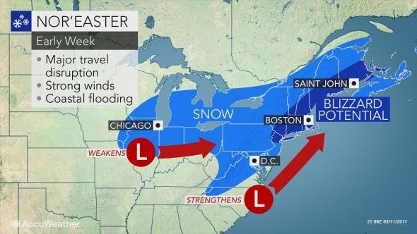
HUDSON VALLEY, NY — The likelihood of a severe late-winter wallop has gotten stronger. Meteorologists say the potential for 12-24 inches of snow to fall on parts of the Hudson Valley from late Monday to Wednesday has gotten stronger.
Three out of four of the computer models tracking the storm now agree, said Bill Potter of Hudson Valley Weather.
"We have more confidence that this nor’easter will take full aim on the Hudson Valley, beginning late Monday night and into Tuesday," Potter said Sunday morning.
Find out what's happening in New Cityfor free with the latest updates from Patch.
Wind gusts could not only create visibility problems but break tree limbs and threaten sporadic power outages.
The nor'easter threatens to shut down travel due to heavy snow and strong winds from Washington, D.C., to New York City and Boston, according to Alex Sosnowski, AccuWeather senior meteorologist.
Find out what's happening in New Cityfor free with the latest updates from Patch.
"This amount of snow over such a broad, heavily populated area could bring travel to a standstill as snow clogs streets and highways and heavy snow and wind trigger airline delays and flight cancellations. Some flights have already been canceled in advance of the storm," he said.
Early this morning the National Weather Service updated its Blizzard Watch for southern Westchester County from late Monday night through Tuesday evening.
Snow accumulations of 12 to 18 inches are possible, along with strong, gusty winds.
Travel during the watch could be hazardous, and there is the potential for power outages due to moderate to heavy snow and gusty winds. Temperatures will be in the upper 20s.
The NWS Winter Storm Watch remains in effect for Orange, Putnam, Rockland and northern Westchester counties from Monday night into Wednesday.
Snow accumulations of 12 to 18 inches are possible. Travel will be hazardous and there is the potential for power outages.
The Winter Storm Watch remains in effect for Dutchess, Columbia and eastern Ulster counties. Forecasts call for greater than 7 inches of snow possible. Travel conditions could be dangerous.
And finally, a Winter Storm Watch remains in effect for western Ulster County. Snow accumulations Tuesday into Wednesday could be greater than 7 inches. Travel conditions could be dangerous.
Get more local news delivered straight to your inbox. Sign up for free Patch newsletters and alerts.