Weather
Snow Could Usher In Valentine's Day In The Hudson Valley
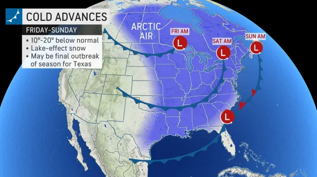
First, a 20-degree temperature swing is expected over the weekend.


HUDSON VALLEY, NY — While folks in Ulster County are thawing out in the above-normal temperatures, meteorologists are turning from last week's disastrous storm (a half- to three-quarters inch of ice fell, wrapping itself around wires and tree limbs and cutting power to 70,000 customers in the region) to the next expected winter event.
(Hudson Valley Weather has an in-depth analysis of what happened Friday and why.)
Meanwhile, a 20-degree temperature swing is expected over the weekend.
Find out what's happening in New Cityfor free with the latest updates from Patch.
More Arctic air is headed our way, and behind it, a storm system that could sneak up the East Coast, said Alex Sosnowski, AccuWeather senior meteorologist.
Five days out, forecasts are always iffy, but in this case there's a lot of uncertainty.
Find out what's happening in New Cityfor free with the latest updates from Patch.
Snow or a wintry mix could spread northward along the Interstate 95 corridor of the mid-Atlantic and New England from Sunday to Monday, Sosnowski said. However, if the disturbance in the southern jet stream ends up following too close behind the dip of the northern jet stream, the storm that will develop could be swept out to sea before moving very far north along the East Coast.
The National Weather Service gives the Hudson Valley a 30 percent chance of snow on Sunday.
Here's the five-day forecast based on Ulster County:
- Tonight - Partly cloudy in the evening, then becoming mostly cloudy. Not as cold with lows around 30. South winds around 5 mph.
- Thursday - Partly sunny. Highs in the mid 40s. Southwest winds 5 to 10 mph.
- Thursday Night - Partly cloudy in the evening, then becoming mostly clear. Cold with lows in the mid 20s. Southwest winds around 5 mph.
- Friday - Sunny. Highs in the lower 40s. Southwest winds 5 to 10 mph.
- Friday Night And Saturday - Mostly cloudy. Lows in the mid 30s. Highs in the upper 40s.
- Saturday Night - Mostly cloudy. Much colder with lows around 20.
- Sunday - Partly sunny with a 30 percent chance of snow showers. Much colder with highs in the upper 20s.
- Sunday Night - Partly cloudy. Cold with lows around 10 above.
SEE ALSO: Central Hudson Continues Ulster County Power Restoration
Get more local news delivered straight to your inbox. Sign up for free Patch newsletters and alerts.