Weather
Snow Totals Change Again for the Hudson Valley
the latest details on what's coming down and what's coming next

HUDSON VALLEY, NY — The snowstorm began early, with flurries south of I-84 at 10 p.m. even while the center of low pressure was in North Carolina.
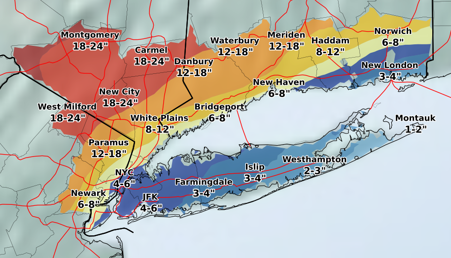
Hudson Valley Weather predicts we'll get 20 to 30 inches of snow (locally up to 36 inches) in Dutchess, Orange, Putnam Rockland, and northern Westchester.
"A tremendous amount of moisture continues to advance from the southwest, all the way down into Virginia, said Bill Potter. "This storm has only gotten under way, we have a long way to go. Snowfall rates of 1 to 2 inches per hour will continue the rest of this morning…. Please don’t travel if you don’t have to."
Find out what's happening in New Cityfor free with the latest updates from Patch.
But as the storm tracked west, the forecast changed for coastal areas south and east of I-95, which should see significantly decreased snowfall amounts, the National Weather Service said.
The snow may mix with sleet at times later this morning into this afternoon. The precipitation will change back to all snow before ending this evening.
Find out what's happening in New Cityfor free with the latest updates from Patch.
Get more local news delivered straight to your inbox. Sign up for free Patch newsletters and alerts.