Weather
Winter Storm Warnings Issued As HV Braces For Snowy Nor'easter
Temperatures are going to be very cold during the storm and afterward, the National Weather Service warns.

HUDSON VALLEY, NY — Winter storm warnings have been issued for the lower Hudson Valley, though there is still a great deal of uncertainty about the complex weather system.
How far west this nor-easter will track as it heads up the East Coast is still unclear, and there is still uncertainty about the duration of moderate and heavy snow banding late tonight into Saturday, the National Weather Service said.
Find out what's happening in New Cityfor free with the latest updates from Patch.
One thing we know: temperatures will be far below freezing.
"This will be a very cold storm which is abnormal for our region, temps during the height of the storm will range from 5 to 15 degrees, Wind-Chills will remain below zero," said Alex Marra and Bill Potter of Hudson Valley Weather.
Find out what's happening in New Cityfor free with the latest updates from Patch.
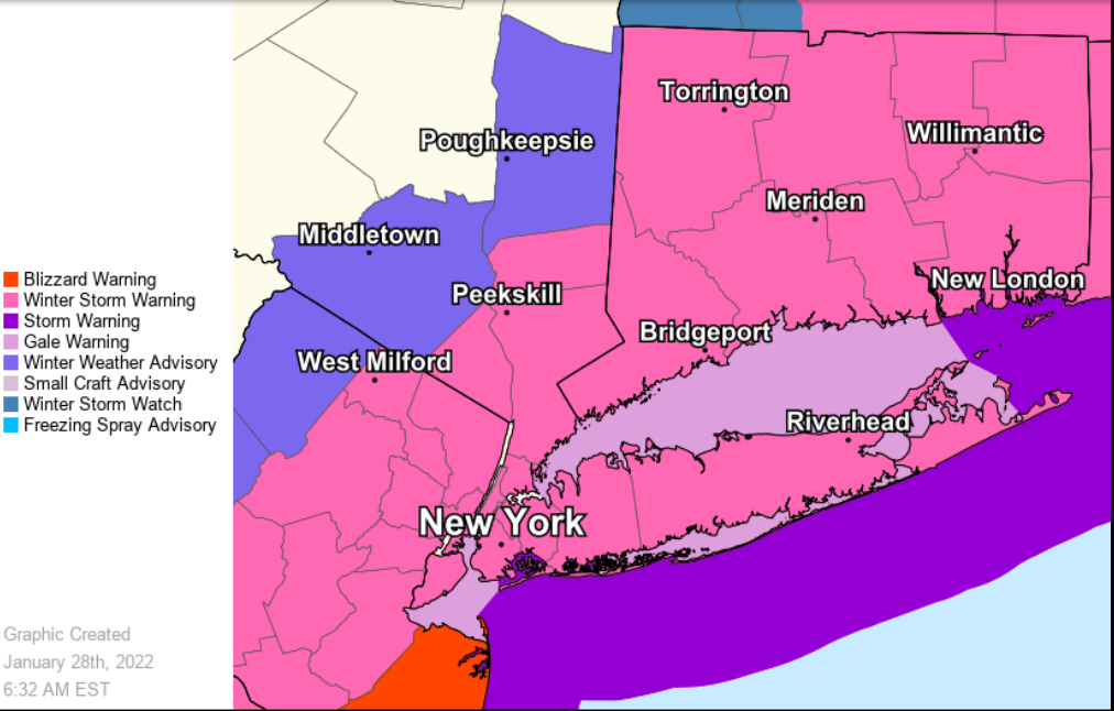
- For southern Westchester County, which is the part of our region predicted to bear the brunt of the storm, the NWS predicts total snow accumulations of 6 to 9 inches and winds gusting as high as 45 mph. Near blizzard conditions are possible for a period. Wind chill values below zero during the day on Saturday.
- For Putnam, Rockland and northern Westchester, heavy snow is expected with a total of 4-7 inches. Snow will start Friday evening and end by Saturday evening. Winds will gust as high as 40 mph.
Winter weather advisories are out for Dutchess and Orange counties, with total snow accumulations of 3 to 7 inches predicted. Winds gusting as high as 40 mph will lead to blowing and drifting snow.
The powdery snow could fall so rapidly at times that visibility will diminish to near zero. Travel will become very difficult. If you must travel, keep an extra flashlight, food, and water in your vehicle in case of an emergency.
Strong winds on Saturday could cause scattered downed tree limbs and power lines.
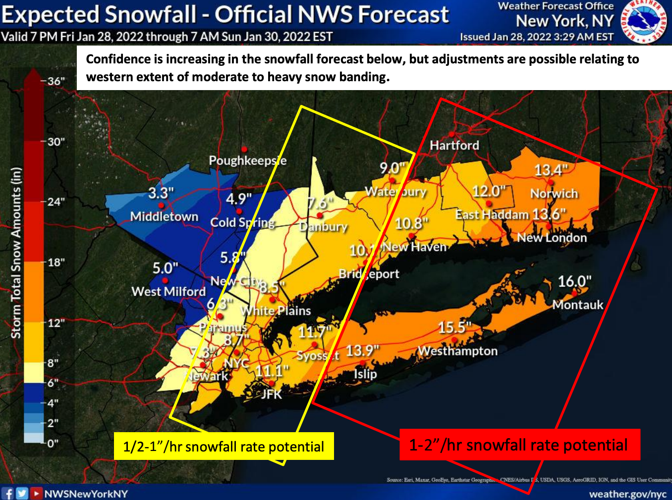
Here's the NWS snowfall prediction as of Friday morning:
Bombogenesis, the term for what happens when barometric pressure plummets swiftly, is expected. The nor'easter will develop and rapidly strengthen into a bomb cyclone as it moves northward along the Eastern Seaboard. AccuWeather forecasters said.
Blizzard conditions are forecast from eastern Long Island through much of coastal New England, particularly from southeast Maine to Cape Cod. This will make travel nearly impossible, the NWS said. Significant beach erosion and coastal flooding will also be a concern.
"The intense storm has the potential to shut down airports, such as Boston Logan International Airport, and could lead to scores of flight cancellations in New York City, Philadelphia and Washington, D.C., that can have ripple effects across the nation as crews and aircraft are displaced," said Ryan Adamson, AccuWeather meteorologist.
Blowing and drifting snow will make conditions worse.
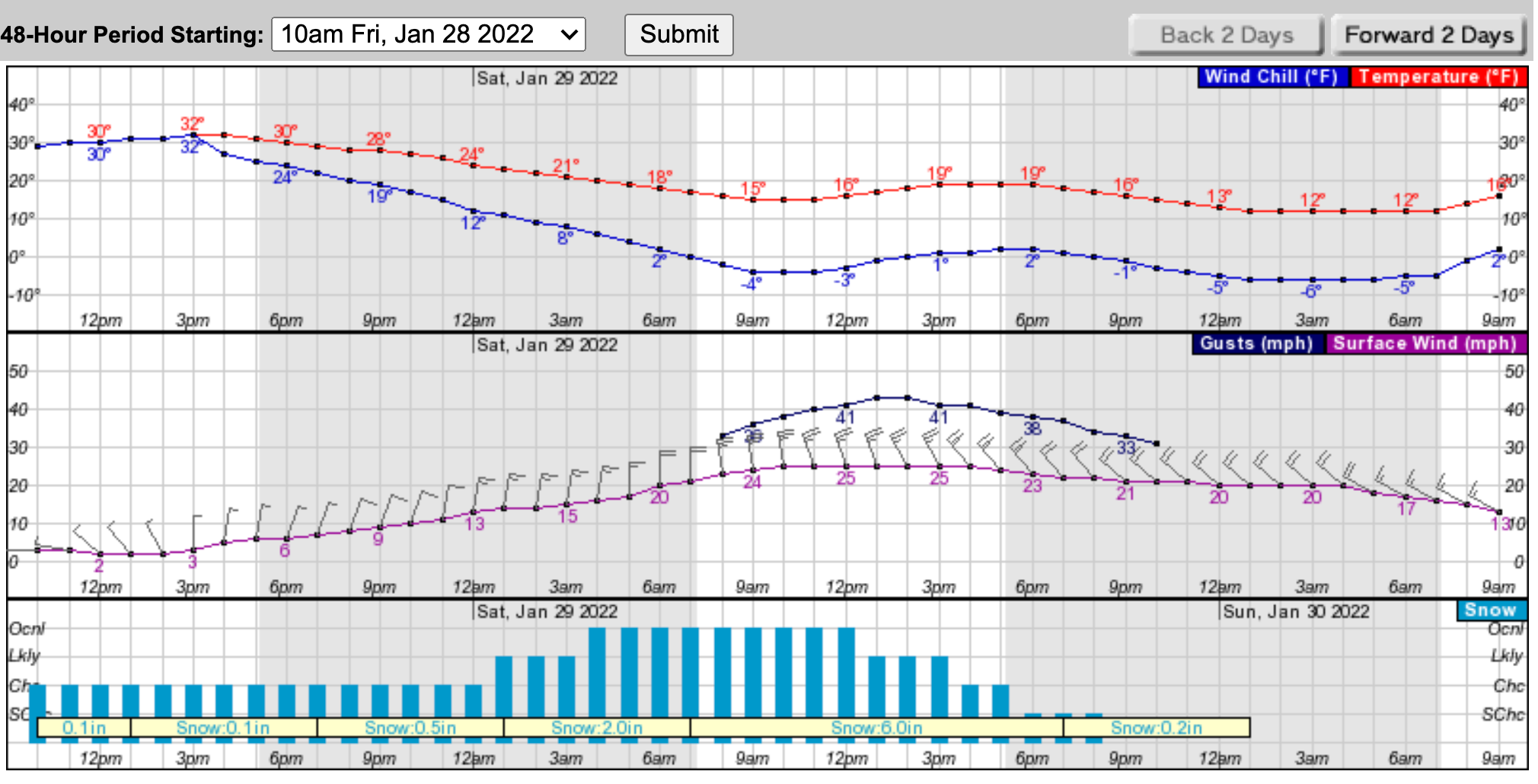
Here's a look at the hour-by-hour forecast based on southern Westchester:
Get more local news delivered straight to your inbox. Sign up for free Patch newsletters and alerts.