Weather
Flood Advisory, Hazardous Outlook For Parts Of Hudson Valley
This storm may become a bomb cyclone. The

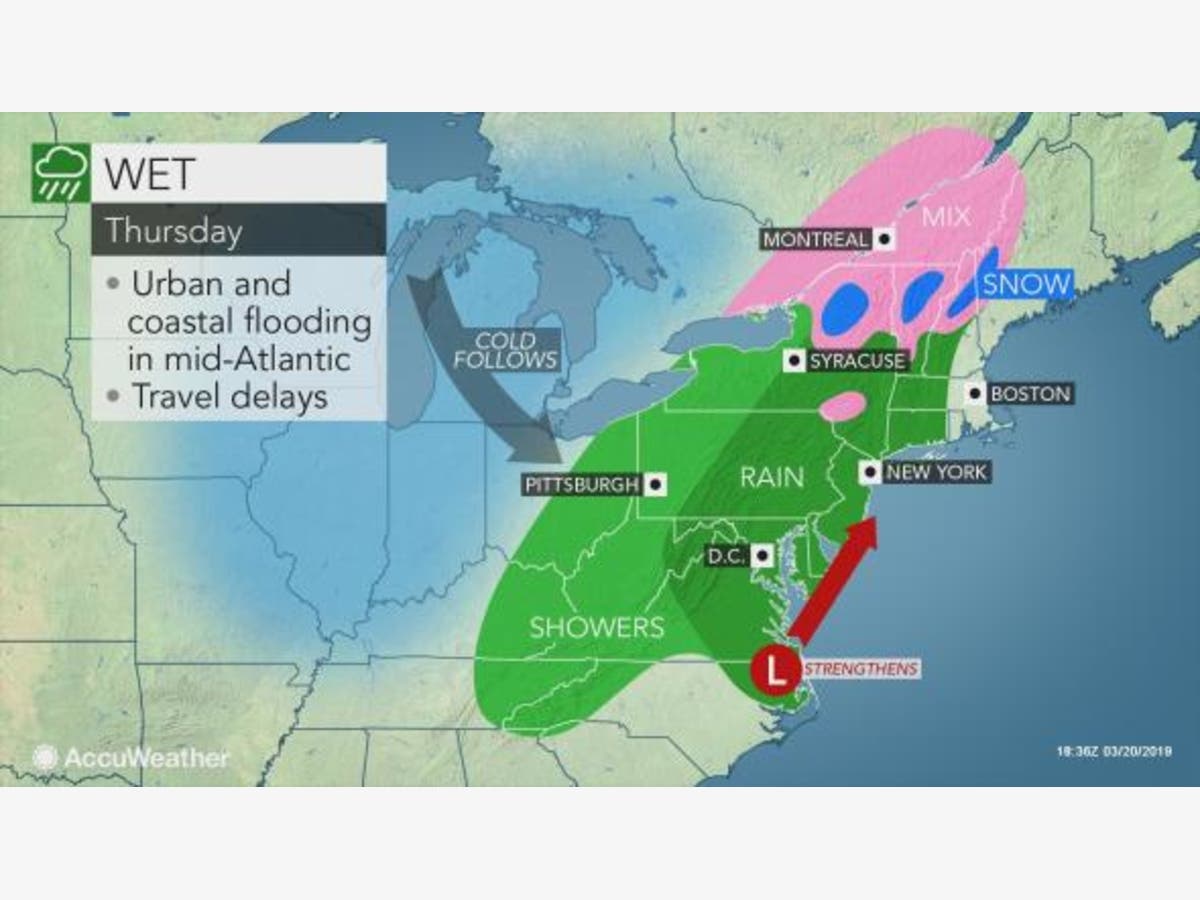
HUDSON VALLEY, NY — The National Weather Service has issued a coastal flood advisory for the sound shore of Westchester and a hazardous weather outlook for for Dutchess and Ulster counties overnight Thursday as a strengthening storm makes its way up the East Coast.
The storm could become a bomb cyclone, Alex Sosnowski, AccuWeather senior meteorologist, said Thursday morning.
For that to happen, the barometric pressure at the center of the storm must plummet 0.71 of an inch of mercury (24 millibars) in 24 hours, he said. Even if it does, it won't be near the strength and size of the massive bomb cyclone that hit the Central states last week.
Find out what's happening in New Rochellefor free with the latest updates from Patch.
The flood advisory runs from 11 p.m. Thursday to 2 a.m. Friday.
- LOCATIONS...Vulnerable coastal locales along the western portions of the Long Island Sound.
- TIDAL DEPARTURE...Around 1 to 1 1/2 ft above astronomical tides tonight.
- COASTAL FLOOD IMPACTS...There is a low threat of property damage. Shallow flooding is expected in the most vulnerable locations near the waterfront and shoreline. Expect around 1 to 2 feet of inundation above ground level in low lying, vulnerable areas. Some roads and low lying property including parking lots, parks, lawns and homes/businesses with basements near the waterfront will experience shallow flooding.
- TIMING...Around high tide tonight.
The hazardous weather outlook is for Friday:
Find out what's happening in New Rochellefor free with the latest updates from Patch.
Strong west to northwest winds will be possible Friday night into Saturday. If confidence increases for frequent wind gusts in excess of 45 mph, then a wind advisory will be needed.
Thursday's rain will be steadiest towards the afternoon and into the evening, with the highest rainfall totals across the western half of the region, with lower totals across the eastern half. Breezy and seasonably cool with highs mainly in the middle and upper 40s.
The rain will continue into the evening, along with a few rumbles of thunder possible. The rain will taper off early Friday morning as the storm system moves quickly to the north
Get more local news delivered straight to your inbox. Sign up for free Patch newsletters and alerts.