UPDATE — A tornado warning was issued for northeastern Orange County. It is in effect until 4:30 p.m.
At 3:56 p.m., a severe thunderstorm capable of producing a tornado was located near Bloomingburg or near Middletown, moving east at 60 mph.
The storm includes quarter-size hail and will be near Newburgh and New Windsor around 4:15 p.m.
Find out what's happening in New Rochellefor free with the latest updates from Patch.
Severe Thunderstorm Warning issued May 15 at 3:34PM EDT until May 15 at 5:00PM EDT by NWS New York City - Upton. The National Weather Service has issued a Severe Thunderstorm Warning for Orange, Putnam, Rockland and Westchester counties, as well as southern Connecticut and northeastern New Jersey.
At 331 PM EDT, severe thunderstorms were located along a line extending from Hazel to near Lava to New Boston-Morea, moving east at 70 mph.
Find out what's happening in New Rochellefor free with the latest updates from Patch.
HAZARD...70 mph wind gusts and quarter size hail.
SOURCE...Radar indicated.
IMPACT...Minor hail damage to vehicles is possible. Expect considerable tree damage. Wind damage is also likely tomobile homes, roofs, and outbuildings.* Severe thunderstorms will be near...Montgomery around 400 PM EDT.Walden around 405 PM EDT. Newburgh and New Windsor around 410 PM EDT. Fahnestock State Park around 420 PM EDT. Lake Carmel around 425 PM EDT. Brookfield and New Fairfield around 435 PM EDT. Danbury and Newtown around 440 PM EDT.
TORNADO...POSSIBLE HAIL...1.00IN ...WIND...70MPH These storms have a history of producing wind damage. Winds gusted to 64 mph in Scranton PA at 317 PM.
SEEK SHELTER NOW inside a sturdy structure and stay away from windows! To report severe weather, contact your nearest law enforcement agency. They will send your report to the National Weather Service office in Upton NY.
Intense thunderstorm lines can produce brief tornadoes and widespread significant wind damage. Although a tornado is not immediately likely, it is best to move to an interior room on the lowest floor ofa building. These storms may cause serious injury and significant property damage.Continuous cloud to ground lightning is also occurring with these storms. Move indoors immediately. Lightning is one of nature`s leading killers. Remember, if you can hear thunder, you are close enough to be struck by lightning.
UPDATE -- A tornado watch is in effect until 8 p.m. for Columbia, Dutchess, Sullivan and Ulster counties. Orange, Putnam, Rockland and Westchester counties are under a severe thunderstorm watch in effect Tuesday until 11 p.m., according to the National Weather Service.
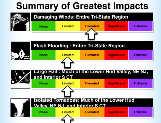
HUDSON VALLEY, NY -- As the heat and humidity mount, there is a strong chance for severe thunderstorms in the Hudson Valley Tuesday afternoon and evening. The National Weather Service has updated its hazardous weather outlook for the entire region, with "enhanced risk" in Dutchess, Orange, Putnam, Rockland and northern Westchester counties.
"We have an elevated risk of strong to severe thunderstorms Tuesday afternoon," said Bill Potter and Alex Marra of Hudson Valley Weather, adding their prediction that the National Weather Service will expand its “Enhanced Risk” designation to the whole region.
The "main threat" will be damaging wind gusts -- up to 65 mph, the NWS said. In addition, the NWS says the lower Hudson Valley could see large hail and isolated tornadoes.
The National Weather Service says :"With this front, there is a possibility of strong to severe thunderstorms. High temperatures will reach the upper 70s to mid 80s."
The heaviest rainfall will be from 4-9 p.m., the NWS predicts.
Keep checking back with Patch as the storms approach.
Image via Shutterstock
Get more local news delivered straight to your inbox. Sign up for free Patch newsletters and alerts.