Community Corner
Cold Temps This Weekend in Piermont and Nyack with a Polar Vortex to Follow
The high will sit in the high 40s tomorrow, and it won't get much warmer next week.

The high temperature in Nyack and Piermont will be in the high 40s on Nov. 8 and “will struggle” to get into the mid 50s on Sunday, says the National Weather Service.
And it will stay cold next week.
Hudson Valley Weather’s been tracking a massive storm forming near Alaska called ExtraTropical Storm Nuri that could lead to temperatures 10 to 15 degrees below average in parts of the Hudson Valley.
Find out what's happening in Nyack-Piermontfor free with the latest updates from Patch.
“For perspective, Hurricane Sandy’s lowest pressure was 940mb… so this storm is like Sandy on steroids. This storm will help to buckle the Jet Stream to our north… and in about 7 days, the impacts will be felt down stream, in the Hudson Valley,” wrote meteorologist Bill Potter on hudsonvalleyweather.com.
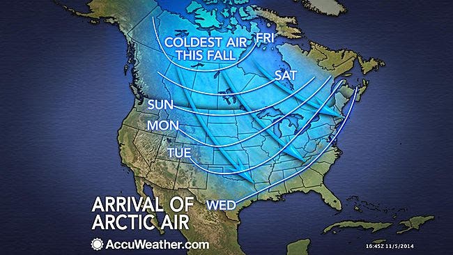
According to AccuWeather.com, Nuri is expected to send part of the polar vortex southward toward the United States next week with an outbreak of arctic air and lake-effect snow.
Find out what's happening in Nyack-Piermontfor free with the latest updates from Patch.
The polar vortex is a large pocket of very cold air, typically the coldest air in the Northern Hemisphere, which sits over the polar region. Occasionally, this pocket of very cold air can get dislodged farther south than normal, leading to cold outbreaks in Canada and the U.S.
The worst of it will be felt from Fargo to Saint Louis, AccuWeather said. But downstate New York will notice.
“While the brunt of the cold air is not likely to be directed toward the I-95 corridor of the East, a breeze accompanying the cold air will make if feel more like December for at least a few days,” wrote Alex Sosnowski, meteorologist for AccuWeather.com.
Get more local news delivered straight to your inbox. Sign up for free Patch newsletters and alerts.