Community Corner
High Winds, Wind Chill, Snow: Hazardous Weather Outlook Today Through Monday
The National Weather Service has issued two advisories and an outlook for Piermont and Nyack.

The small weather event forecast by the National Weather Service overnight brought a couple of inches of snow.
But it’s what’s coming behind it that the NWS is treating as more than routine winter weather.
- The Wind Advisory is in effect from 4 PM this afternoon to 4 PM tomorrow for Putnam, Rockland and Westchester counties. Winds from the northwest will blow 15-25 mph with gusts up to 50 mph. The strong winds could down power lines and tree limbs and make driving difficult, specially for high-profile vehicles.
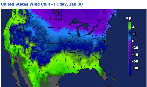
- The Wind Chill Advisory in effect from midnight tonight until noon Saturday for Putnam, Rockland and Westchester counties predicts wind chills as low as 20 degrees below zero. Northwest winds will blow at a sustained 20-25 miles an hour. Why an advisory? Frostbite and hypothermia are easy to come by in these conditions.
- The Hazardous Weather Outlook starts out talking about the wind and wind chill and then segways into a prediction of up to 6 inches of snow Sunday night and Monday. “Although the exact track and timing of the system are still uncertain, there is the potential for 6 inches or more of snow across the entire area.”
“If you venture outdoors, wear a wind repellant coat, hat and gloves,” says the NWS.
Find out what's happening in Nyack-Piermontfor free with the latest updates from Patch.
“From near New York City to southern New England, there are still huge piles of snow left from the new storm, in the wake of the snowfall from Monday’s storm,” said accuweather.com Senior Meteorologist Alex Sosnowski. “Crews may want to make room for the new snowfall coming.”
MAP: accuweather.com
Find out what's happening in Nyack-Piermontfor free with the latest updates from Patch.
Get more local news delivered straight to your inbox. Sign up for free Patch newsletters and alerts.