Community Corner
National Weather Service Issues Blizzard Warning for Nyack, Piermont
30 inches possible, wind gusts up to 45 miles an hour

The National Weather Service has upgraded its bulletin to a Blizzard Warning. The exact track of Storm Juno could mean the difference between two and three feet of snow locally between tomorrow morning and the end of Jan. 27.
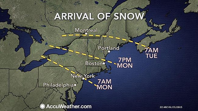
Here’s the preliminary timeline from Hudson Valley Weather:
- Light snow begins Monday, between 6am and 10am from southwest to northeast
- Light snow falls periodically thru the day on Monday… accumulating up to 2 inches.
- Snow becomes steadier Monday night, heavy at times after midnight, with increasing wind
- Heavy snow Tuesday morning, with blowing snow and howling winds
- Periods of moderate to heavy snow continue thru Tuesday afternoon and into Tuesday night
- Snow tapers off early Wednesday
Here’s the day-by-day for Nyack from the National Weather Service.
Find out what's happening in Nyack-Piermontfor free with the latest updates from Patch.
- MondayA chance of snow before 10am, then snow likely between 10am and 1pm, then snow with widespread blowing snow after 1pm. High near 25. Wind chill values between 10 and 15. Northeast wind 8 to 14 mph, with gusts as high as 25 mph. Chance of precipitation is 90%. New snow accumulation of 1 to 3 inches possible.
- Monday NightSnow with widespread blowing snow. The snow could be heavy at times. Some thunder is also possible. Low around 20. Wind chill values between zero and 10. Windy, with a north wind 15 to 20 mph increasing to 28 to 33 mph after midnight. Winds could gust as high as 46 mph. Chance of precipitation is 100%. New snow accumulation of 10 to 14 inches possible.
- TuesdaySnow with widespread blowing snow. The snow could be heavy at times. Some thunder is also possible. High near 23. Wind chill values between zero and 5. Windy, with a northwest wind 32 to 34 mph, with gusts as high as 48 mph. Chance of precipitation is 100%. New snow accumulation of 11 to 17 inches possible.
- Tuesday NightSnow with widespread blowing snow before 1am, then widespread blowing snow and a chance of snow between 1am and 4am, then widespread blowing snow and a slight chance of snow after 4am. Low around 14. Windy, with a northwest wind 27 to 32 mph decreasing to 18 to 23 mph after midnight. Winds could gust as high as 43 mph. Chance of precipitation is 80%. New snow accumulation of 1 to 3 inches possible.
“This could turn out to be the biggest storm of the winter for many areas in the Northeast and could rank among the greatest snowstorms in some communities,” accuweather.com meteorologists said.
Please make sure you have the supplies and medications you will need over next few days. Check on your neighbors, including the elderly. If you have to venture out during the snow, remove all snow from your car before driving.
Find out what's happening in Nyack-Piermontfor free with the latest updates from Patch.
The snow won’t be going anywhere when the storm ends. Temperatures are expected to dip, and more snow is expected toward the end of the week.
MAP: accuweather.com
Get more local news delivered straight to your inbox. Sign up for free Patch newsletters and alerts.