Weather
NOAA's Winter Outlook: Warmer Northeast
What can we expect for the season? How about for the weekend?


HUDSON VALLEY, NY — NOAA’s Climate Prediction Center issued a report Thursday forecasting above-average temperatures this winter in the region — actually across most of the eastern U.S. — as La Nina climate conditions have emerged for the second winter in a row.
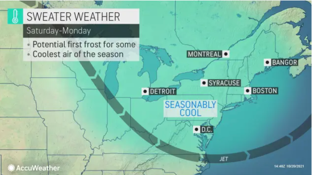
Still, the immediate forecast is for some cooler weather.
The seasonal outlook from the division of the National Weather Service complements but in some places differs from earlier winter forecasts from AccuWeather and the Farmers Almanac.
Find out what's happening in Nyack-Piermontfor free with the latest updates from Patch.
Find out what's happening in Nyack-Piermontfor free with the latest updates from Patch.
AccuWeather published its annual winter forecast in early October, giving people time to prepare for what is expected to be a busy holiday travel season. According to their predictions, the first blast of wintry weather could hit the Northeast as early as November.
The National Weather Service thinks the winter could be too warm to be very snowy.
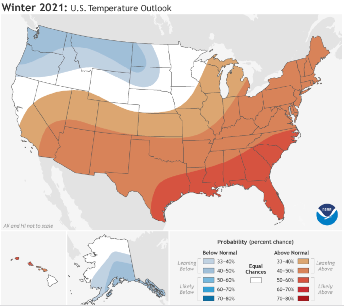
While AccuWeather and the National Weather Service disagree on temperatures, they agree on La Nina.
Like its counterpart El Nino, La Nina has its start in the Pacific Ocean and can influence weather all over the world.
“La Niña is basically the cooling of the surface water in the central and/or eastern Equatorial Pacific and the warming of surface water in the western Equatorial Pacific,” AccuWeather Long-Range Expert Paul Pastelok said in 2020. “This causes changes in the surface and upper wind patterns that drive air masses across the globe."
Seasonal outlooks help communities prepare for what is likely to come in the months ahead and minimize weather's impacts on lives and livelihoods, NWS officials said. Empowering people with actionable forecasts and winter weather tips is key to NOAA’s effort to build a more Weather-Ready Nation. And they issued a caveat: The outlook does not project seasonal snowfall accumulations as snow forecasts are generally not predictable more than a week in advance.
As for right now, AccuWeather Senior Meteorologist Alex Sosnowski said more chilly temps are on tap. About time.
"While September temperatures were 1 to 3 degrees above average in the region, the first 20 days of October have been incredibly warm. Temperatures so far this month have averaged 5 to 10 degrees above normal for much of the region, even when factoring in the temperature dip last weekend," he said.
It has been so mild, he said, that the low temperature in New York City had failed to drop below 50 F until Monday morning, when the mercury hit 49. That milestone approached a record late date, which stands at Oct. 20, 2005.
Frost is still unlikely in the Hudson Valley over the coming weekend, though the Adirondacks could see a hard freeze, he said.
Here's the four-day forecast from the National Weather Service (based on Putnam County):
- Thursday Afternoon - Mostly sunny. Highs in the lower 70s. South winds 5 to 10 mph.
- Thursday night - Partly cloudy in the evening, then becoming mostly cloudy. A 40 percent chance of showers. Lows in the mid 50s. South winds 5 to 10 mph.
- Friday - Mostly sunny. Highs in the mid 60s. West winds around 5 mph.
- Friday Night - Mostly cloudy. Lows in the mid 40s. North winds around 5 mph.
- Saturday - Mostly cloudy in the morning, then becoming partly sunny. Highs in the mid 50s. Northwest winds around 5 mph.
- Saturday Night - Partly cloudy in the evening, then clearing. Lows in the lower 40s.
- Sunday - Sunny. Highs in the upper 50s.
- Sunday Night - Mostly cloudy. A chance of showers after midnight. Lows in the lower 40s. Chance of rain 30 percent.
Get more local news delivered straight to your inbox. Sign up for free Patch newsletters and alerts.

