Weather
Flooding Starts As Nor'Easter Pounds The Hudson Valley
Hudson Valley Weather describes it as "a wall of water" moving west to east.

HUDSON VALLEY, NY — The nor'easter dumping heavy rain on the region has made flooding a major concern for the third time in two months. A state of emergency has been declared including Orange, Putnam, Rockland and Westchester counties.
The National Weather Service issued a flood advisory at 6 a.m. for Rockland and southern Westchester County as well as the Bronx and Bergen and Passaic in New Jersey.
Traffic Advisory: ROAD CLOSURE - Taconic State Parkway north and south all lanes closed due to flooding between Commerce Street and Stevens Avenue. T/Mount Pleasant, Westchester Co.
— NewYorkStatePolice (@nyspolice) October 26, 2021
The NWS warned that minor flooding was expected to begin soon in: Yonkers, New Rochelle, White Plains, Port Chester, Bergenfield, Paramus, West Milford, Ridgewood, Monsey, Nanuet, Rye, Ramsey, Ringwood, Tarrytown, Pompton Lakes, Dobbs Ferry, Suffern, Nyack, Tappan and Sloatsburg.
Find out what's happening in Nyack-Piermontfor free with the latest updates from Patch.
Already between 0.5 and 1.5 inches of rain have fallen, the NWS said.
A flash flood watch continues across the region until 6 p.m. and a coastal flood advisory is in effect. Gale and storm warnings are in effect for all marine waters.
Find out what's happening in Nyack-Piermontfor free with the latest updates from Patch.
The strong winds will intensify Tuesday evening and could lead to power outages, the NWS warned. Con Edison as of 8:50 a.m. is already dealing with two weather-related outages in Westchester, in Port Chester and Mount Vernon, involving about 900 customers.
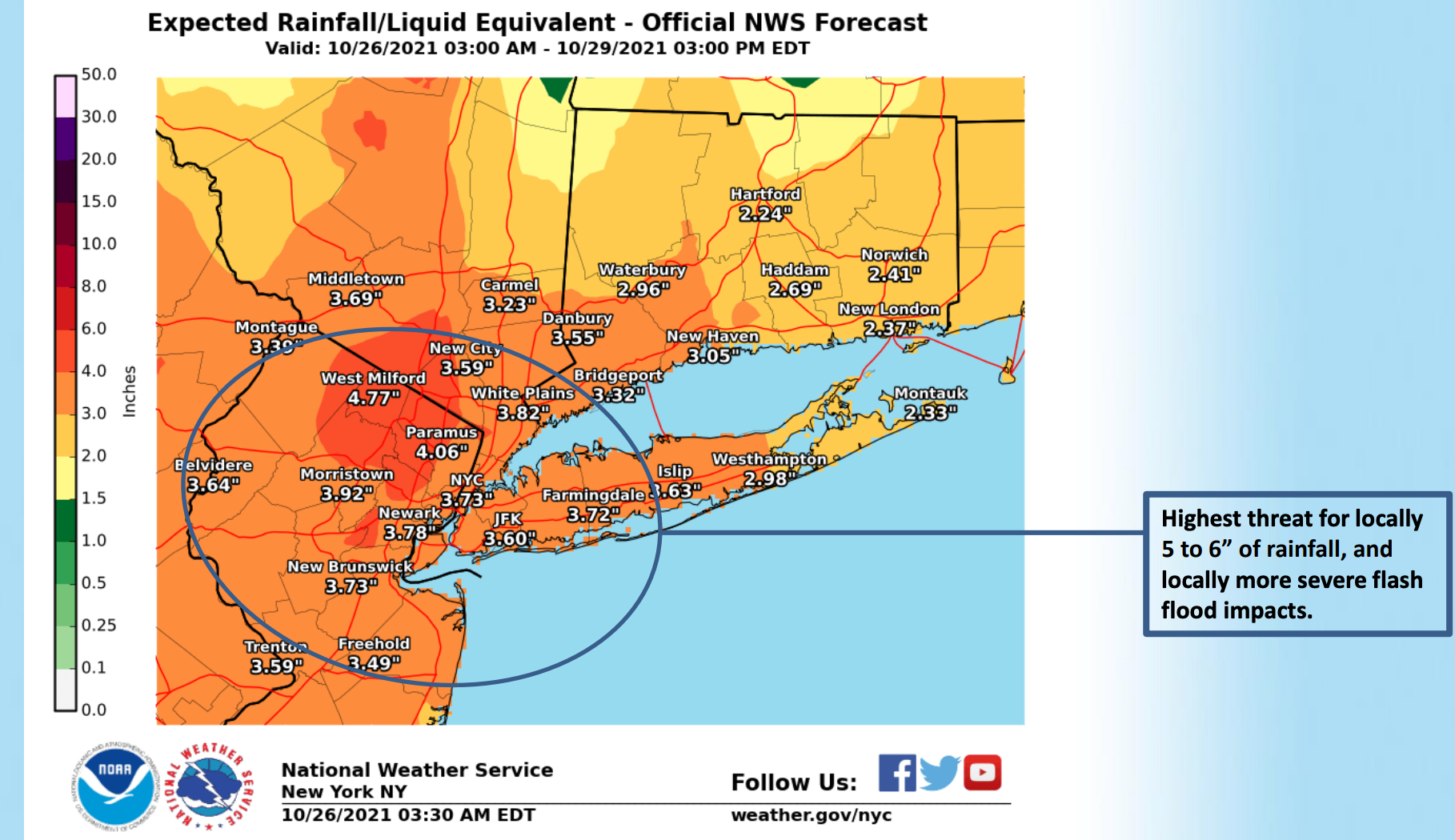
Three to five inches of rain are forecast for the Hudson Valley, and locally 5-6 inches are possible in parts of the tri-state area, the National Weather Service said.
Some roads are already flooded, Westchester County reported as of 8:14 a.m.:
- The Bronx River Parkway is closed in both directions at Main Street in White Plains.
- The Saw Mill River Parkway at Tuckahoe Road northbound is closed and there is heavy ponding in the southbound lanes in Mount Kisco near milemarker 23.9
"As the storm strengthens, it could undergo a period of rapid intensification known as bombogenesis, which is when the central pressure of a storm drops by 0.71 of an inch of mercury (24 millibars) or more over a 24-hour period to become what is known as a bomb cyclone," said Nicole LoBiondo, AccuWeather meteorologist. "Two similar storms developed in the northern Pacific and slammed into the western U.S. late last week and over the weekend."
New York Gov. Kathy Hochul declared a State Disaster Emergency on Monday evening ahead of the storm. She directed state agencies involved in emergency response to prepare assets for deployment to affected areas including Orange, Putnam, Rockland and Westchester counties.
Rain will end Wednesday morning as the storm moves off. But AccuWeather forecasters say it's just the first of multiple storms that take aim at the Northeast during the final week of October.
Here's the five-day forecast:
- Tuesday - Rain with a chance of thunderstorms this morning, then rain this afternoon. Rain may be heavy at times this morning. Highs in the lower 60s. Northeast winds 10 to 15 mph with gusts up to 30 mph. Chance of rain near 100 percent.
- Tuesday night - Rain. Lows around 50. North winds 15 to 20 mph with gusts up to 30 mph. Chance of rain 90 percent.
- Wednesday - Partly sunny. A slight chance of showers in the morning. Highs in the upper 50s. North winds 15 to 20 mph with gusts up to 30 mph. Chance of rain 20 percent.
- Wednesday Night - Partly cloudy in the evening, then clearing. Lows in the lower 40s. North winds 10 to 15 mph with gusts up to 25 mph.
- Thursday - Sunny. Highs in the upper 50s. Northeast winds 5 to 10 mph.
- Thursday Night
- Mostly cloudy. Lows in the lower 40s.
- Friday - Mostly cloudy. A chance of rain in the morning, then rain likely in the afternoon. Highs in the mid 50s. Chance of rain 70 percent.
- Friday Night - Rain. Lows in the upper 40s. Chance of rain 80 percent.
- Saturday - Rain likely. Highs around 60. Chance of rain 60 percent.
- Saturday Night - Mostly cloudy. Rain likely, mainly in the evening. Lows in the upper 40s. Chance of rain 60 percent.
Get more local news delivered straight to your inbox. Sign up for free Patch newsletters and alerts.

