Image courtesy of AccuWeather.com
We will be updating this page throughout the weekend with the most current forecasts. Refresh the page for the latest.
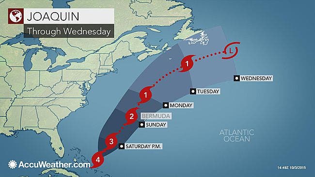
As Joaquin has strengthened to near Category 5 hurricane status, according to AccuWeather.com, the National Weather Service has issued a Coastal Flooding Advisory for southern Westchester.
Find out what's happening in Nyack-Piermontfor free with the latest updates from Patch.
The NWS says high tide plus the storm’s onshore winds could cause minor flooding in communities along the western Long Island Sound Saturday afternoon.
While the powerful hurricane is tracking away from the coast, indirect impacts will still threaten lives and property in parts of the eastern United States into Monday.
Find out what's happening in Nyack-Piermontfor free with the latest updates from Patch.
Seas and tide levels will remain high from the Carolinas to Massachusetts into Monday. East to northeast gusts may frequently reach 40 mph.
“People in the Carolinas should be prepared to move to higher ground to protect life if flood waters approach their homes,” AccuWeather Meteorologist Mike Doll said. “If you are driving and come across a flooded roadway, your best option is to turn around and find an alternative route.”
AccuWeather.com said that a rainfall report received by the Citizen Weather Observer Program indicates that 16 inches fell one mile north of Little River, South Carolina. If deemed official, that would be a new 24-hour rainfall record for South Carolina. Nearby Myrtle Beach currently holds the record when 14.80 inches poured down during Hurricane Floyd on Sept. 16, 1999.
People in the eastern United States should not let their guard down due to a shifting track of the hurricane, meteorologists warned.
New York Gov. Andrew M. Cuomo said additional resources and personnel from various state agencies are being deployed to assist state and local crews with both preparing for and responding to the possible impact of the storm.
“The latest weather reports have good news for New York, with Hurricane Joaquin expected to veer off into the Atlantic – but we are continuing to prepare for every possible outcome in order to keep people safe,” said Cuomo in a prepared statement. “We’ve seen what Mother Nature can do, and we are not taking anything for granted with this storm. I encourage all New Yorkers to take appropriate precautions and to stay informed as the weather develops.”
New Yorkers are encouraged to sign up for NY-Alert in order to receive immediate notifications on flood warnings and severe storms, as well as follow @NYGovCuomo and @NYGov on Twitter for official updates.
Division of Homeland Security and Emergency Services
The Division of Homeland Security and Emergency Services continues coordination of the State Emergency Operations Center in Albany. In addition, the Emergency Services group has approximately 100 personnel prepared for deployment as needed, and various response and communications vehicles that have been readied for any eventuality from our current weather events, including:
- · Office of Emergency Management: NYS Mobile Emergency Incident Command Post
· Office of Fire Prevention and Control: 3 ATVs; 3 Zodiac Boast; 2 High Axel Vehicles; 3 Swift Water Rescue Units; 1 Urban Search and Rescue team
· Office of Interoperable and Emergency Communications: 1 ATV; 5 Strategic Technology Reserve Vehicles; 3 Rapid Application Mobile Emergency Radios
Department of Transportation
The State Department of Transportation has 110 job sites in the downstate region that are being assessed for readiness and will be secured as necessary. NYSDOT staff is clearing and assessing culverts as well as inspecting job sites throughout the downstate region – specifically 240 personnel in the Hudson Valley, 20 personnel in New York City, and 200 personnel on Long Island. Additional staff is providing support to sandbag filling efforts led by the Division of Homeland Security and Emergency Services.
NYSDOT is also stockpiling equipment in the Hudson Valley, New York City and Long Island Regions to prepare for the storm’s impact. Resources assigned to the downstate regions include:
- · 90 Variable Message Signs
· 436 Large Dump Trucks
· 21 Non Plow Medium Duty Dump Trucks
· 29 Large Bucket Loaders
· 10 Sweepers
· 2 Tree Bucket Trucks
· 10 CatchVacs/Sewer Jets
· 4 Vac Ons (Large Sewer Jets)
· 98 Impact Attenuators
· 2 Large Track Hoes
· 1 Small Track Hoe
· 12 Large Chippers
· 1 Large 6” Debris Water Pump
· 4 Excavators
· 20 generators
· 1 Road Grader
Additionally, NYSDOT is repositioning 20,000 more sandbags to the Hudson Valley for deployment as needed.
State Police
State Police will be staffing the State Emergency Operations Center around the clock, and Troop personnel are ready for assignment to county and local Emergency Operations Centers (EOC) as needed. All emergency power and communications equipment has been tested, and all necessary equipment has been staged for quick deployment, including aircraft, rescue boats and four-wheel drive vehicles.
Canals Corporation
On Tuesday, the Canal Corporation issued a Notice to Mariners advising of probable high water and canal closures related to heavy rainfall and then-Tropical Storm Joaquin. An updated notice was issued yesterday after Joaquin was upgraded to a Category 3 Hurricane.
The Corporation is making preparations to offer safe harbor of refuge within the Waterford Flight late this weekend to commercial and recreational vessels. Marinas along the Mohawk River are also being notified of the possibility that movable dams will need to be removed as early as Sunday, depending on the development of Hurricane Joaquin’s forecast.
There is 18 feet of storage available in the Hinckley Reservoir and Canal staff are drawing down levels and building additional storage where possible.
The Corporation is coordinating closely with hydroelectric operators and other water management entities along or adjacent to the Canal relative to current and predicted flows, as well as with the New York Power Authority relative to the operation of the Hinckley Reservoir and other preemptive measures at Crescent and Vischer Ferry dams.
Department of Environmental Conservation
Additional actions and updates from the Department of Environmental Conservation include:
- · Oil Spill Response Preparedness – DEC spills response staff are contacting Major Oil Storage Facilities operators to ensure that plans are in place to harden their facilities for the possibility of heavy winds, storm surge and flooding associated with a possible hurricane. Spills staff is also coordinating with its contractors to be ready to respond to oil and hazardous materials spills if needed.
· DEC has personnel and equipment working to clear streams at Normanskill Creek and Esopus Creek, and staff are working with local officials to monitor existing conditions and identify additional sites requiring debris clearance.
New York Power Authority
NYPA is filling the upper reservoir at the Gilboa Power Project to create more space for the facility to accept water as the storm develops. All scheduled work throughout the NYPA system is being evaluated for potential impact amid the storm and nonessential projects are being postponed. NYPA’s generating plants, transmission system and operational staff are prepared to respond and adapt as weather conditions develop, and all resources required for safe, efficient operations (personnel, equipment, vehicles, etc.) have been put in place or placed on standby.
Office of Parks, Recreation and Historic Preservation
State Parks is taking measures to protect its parks and facilities from the storm including:
- · 150 operations staff conducting storm preparations, to include ýbuilding a berm of sand 4 feet high by 8 feet wide and approximately one mile long in front of Jones Beach.
· Preparing sand bags to be placed around several beachfront buildings and removing all trash receptacles, signs and unsecured items from the beachfront at Jones Beach, Robert Moses, Orient and Hither Hills state parks.
· Securing windows and doors with plywood and securing all equipment at Jones Beach and Robert Moses .
· Assembling and fueling all needed emergency response equipment, protective clothing and vehicles at all state parks across the Hudson Valley, New York City and Long Island.
· Continuously monitoring culverts and other flood-prone areas for debris at all state parks across the Hudson Valley, New York City and Long Island.
· Starting to lower lake levels in the potentially affected areas of Harriman State Park, to prepare for the additional inflow of stormwater.
· 550 operations staff and Park Police are on the ready to assist State Police and DOT as needed.
· Providing a staging area at Bethpage, Valley Stream, Hempstead Lake and Sunken Meadow State Parks to PSE&G utility crews.
Forecast models continue to show Hurricane Joaquin tracking further east into the Atlantic Ocean, according to the National Hurricane Center.
And the National Weather Service has issued these for southern Westchester:
- Coastal Flood Advisory in effect from October 2, 02:00 PM EDT until October 2, 06:00 PM EDT
- Hazardous Weather Outlook
That’s because winds, seas and tide levels will continue to build from the Carolinas to Massachusetts through the weekend, said Alex Sosnowski, AccuWeather.com Senior Meteorologist.
The onshore winds alone, in absence of Joaquin reaching the coast, could cause water levels to rise to an average of 2-3 feet above normal tides. These conditions are likely to occur hundreds of miles to the north of the storm’s center. Winds could become strong enough to down trees and power lines and cause minor property damage.
While the news is definitely welcome, the National Weather Service’s latest forecast still calls for rain.
Weekend forecast
Currently, Friday, Oct. 2 is shaping up to the be the rainiest day, according to the National Weather Service.
The chance of rain in Rockland County 100 percent Friday night. By Saturday, that drops to 80 percent. By Monday it’ll be partly sunny and 67.
In Putnam County, there’s a 100 percent chance of rain tonight. Gusty rain on Saturday, but by Monday it’ll be partly sunny and 65.
For northern Westchester, the chance of rain Friday is 100 percent tonight. Gusty rain on Saturday, and partly sunny by Monday.
Everywhere it will be cool -- mid-50s on Friday and Saturday and then up just a little into the 60s.
Be prepared
A graphic of the hurricane’s projected path is being updated constantly by the NHC.
A state of emergency had already been declared in Virginia, North Carolina and New Jersey.
New York did not follow suit, but Governor Andrew Cuomo did issue an emergency statement directing state agencies to “prepare for prolonged heavy rains and tropical storm conditions” in the coming days.
Cuomo offered residents tips on being prepared:
- Know your weather terms – A flash flood “watch” indicates flash flooding or flooding is possible within the designated watch area. When a watch is issued, be alert and ready to take action. A flash flood “warning” means flash flooding or flooding has been reported or is imminent. You should take necessary precautions and actions at once.
- Stock up on emergency supplies, including non-perishable food and water, to last for more than 72 hours or three days.
- Know how to contact all family members at all times. Identify an out-of-town friend or family member to be the “emergency family contact” and make sure all family members know that number.
- Designate a family emergency meeting point – a familiar location where the family can meet in case the home is inaccessible.
- Prepare an emergency phone list of people and organizations that may need to be called, including schools, doctors, child/senior care providers, and insurance agents.
- Know the hurricane / storm risks in your area, including storm surge history.
- Learn about your community’s warning signals and evacuation plans.
- Start thinking about where to relocate your pets during a storm.
- Stock up on prescribed medicines and prepare supplies for persons with special needs such as children, the elderly, and infirm.
- Check on neighbors to ensure they are aware of the potential danger and what they need to do to prepare for the storm.
“Our state has seen the damage that extreme weather can cause time and time again – and I am urging New Yorkers take precautions for more heavy storms in the coming days,” Cuomo said in a prepared statement. “Tropical Storm Lee and Hurricane Irene proved that you do not have to be near the coast to be impacted by Mother Nature. I have directed State agencies to ready their emergency response equipment in partnership with local governments, and I encourage all of our state’s residents to be prepared and stay safe.”
Patch Editor Simone Wilson contributed to this report.
Get more local news delivered straight to your inbox. Sign up for free Patch newsletters and alerts.