Weather
Wind Chill, Snow Estimates Revised: Hudson Valley Forecast
The weekend will be a winter weather whirlwind starting with "a double bombogenesis" Friday night.


HUDSON VALLEY, NY — The National Weather Service has updated its wind chill advisories across the region, warning that plunging temperatures and gusty winds will create hazardous conditions Friday night into Saturday.
Wind chills of 15 to 25 below zero can be expected in Dutchess and Ulster counties.
Orange, Putnam and northern Westchester counties could experience wind chills as low as 15 below zero. For Rockland and southern Westchester, the NWS warns of winds chills of zero to 10 below late Friday night into Saturday morning.
Find out what's happening in Nyack-Piermontfor free with the latest updates from Patch.
This is hypothermia weather, so use caution while outside and when traveling. Wear appropriate clothing, a hat, and gloves.
It's due to Arctic air being pulled into the region by a rapidly deepening storm out in the Atlantic. "Our passing ocean storm will kick up some gusty winds this evening, especially east of the river — can’t rule out some isolated power issues and given the cold air overnight any outages would be impactful," said Alex Marra and Bill Potter of Hudson Valley Weather.
Find out what's happening in Nyack-Piermontfor free with the latest updates from Patch.
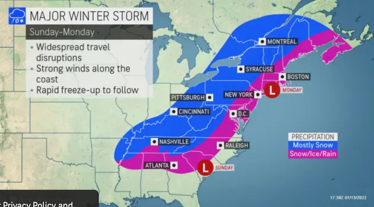
Then the next storm is due late Sunday, and it "will be running straight into the wall of deep cold air," Hudson Valley Weather said.
Utility companies are prepping for outages from that nor’easter expected to sweep through the region into Monday.
The northern and western suburbs of New York City will lie within a battle zone between warm and cold air associated with the storm, according to AccuWeather Chief On-Air Meteorologist Bernie Rayno. Heavy snow will change to sleet, freezing rain and rain on Monday in areas north and west of the city — the question is when, and how much snow will fall beforehand.
The National Weather Service is now predicting snow totals of 6.5 inches in Middletown, 4.6 in Cold Spring, 4.2 inches in New City and 2.2 in White Plains.
Thundersnow is possible.
Also, Southern Westchester has a hazardous outlook posted because the second storm will bring the potential for coastal flooding for the high tide cycles Sunday night and Monday during the day. "The Monday daytime coastal flooding looks to be the worse of the two, being widespread with the possibility of moderate to major coastal flooding," the NWS said.
Then, cold air will rush in again in the wake of the system on Monday night, said Alex Sosnowski, AccuWeather senior meteorologist. "Any wet and slushy areas will freeze, leaving untreated roads, sidewalks and parking lots slippery and dangerous. "
Here's the forecast for the weekend, based on western Dutchess:
- Friday night
- Mostly clear. Much colder with lows around 4 above. North winds around 15 mph with gusts up to 35 mph. Wind chill values as low as 12 below after midnight.
- Saturday
- Mostly sunny. Much colder with highs around 16. North winds 10 to 15 mph. Gusts up to 30 mph in the morning. Wind chill values as low as 13 below in the morning.
- Saturday Night
- Partly cloudy in the evening, then clearing. Cold with lows around 2 above. North winds around 5 mph.
- Sunday
- Sunny. Not as cold with highs in the mid 20s. Light and variable winds, becoming east around 5 mph in the afternoon.
- Sunday Night
- Snow. Moderate snow accumulation. Not as cold with lows around 20. Temperature rising into the upper 20s after midnight. Chance of snow 90 percent.
- Martin Luther King Jr Day
- Snow, mainly in the morning. Additional light snow accumulation. Not as cool with highs in the mid 30s. Chance of snow 90 percent.
- Monday Night
- Mostly cloudy in the evening, then becoming partly cloudy. Cold with lows around 20.
Westchester County Executive George Latimer asked residents to check on their elderly and frail neighbors and heat their homes safely.
"Wintry weather can further isolate those who are homebound and frail, so it is a good idea to be neighborly," he said. "Remember also to take precautions to keep yourself and your family warm and safe in these arctic conditions.”
Hypothermia happens when a person exposed to cold loses heat faster than it can be produced. Warnings signs of hypothermia in adults include shivering, exhaustion, confusion, fumbling hands, memory loss, slurred speech and drowsiness. In infants, look for bright red, cold skin and low energy. If you see any of these signs, take the person’s temperature. If it is below 95°, get medical attention immediately.
Frostbite is an injury that causes a loss of feeling and color and most often affects the nose, ears, cheeks, chin, fingers, or toes. Frostbite can cause permanent damage. The risk is increased in people with reduced blood circulation and among people who are not dressed properly for extremely cold temperatures.
At the first signs of redness or pain in any skin area, get the person out of the cold or protect any exposed skin. Seek immediate medical care. Signs of frostbite include white or grayish-yellow skin, numbness or skin that feels unusually firm or waxy. Victims are often unaware of frostbite until someone else points it out because the frozen tissues are numb.
To avoid hypothermia and frostbite:
- Dress warmly in layers.
- Be aware of the wind chill factor.
- Work slowly when doing outside chores.
- Take a buddy and an emergency kit when you participate in outdoor recreation.
- Carry a cell phone.
Get more local news delivered straight to your inbox. Sign up for free Patch newsletters and alerts.

