Weather
Wind-Storm Prep for the Tappan Zee Bridges: Cuomo
They're battening down at the current bridge and the new bridge construction zones.

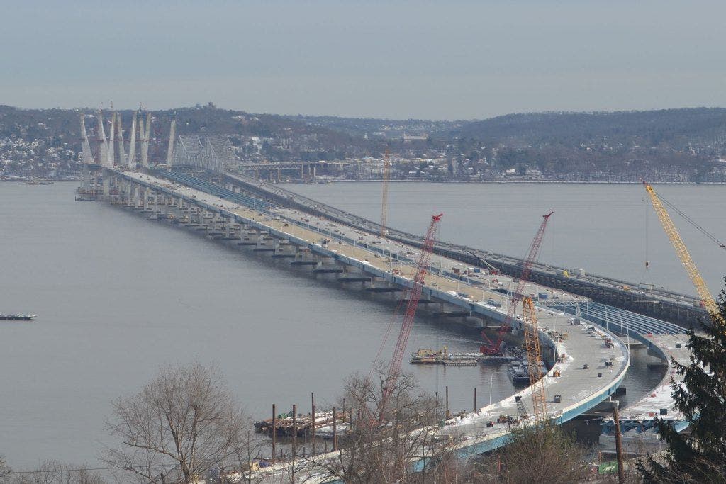
With heavy rain, snow, sleet and freezing rain along with strong gusting winds forecast for the lower Hudson Valley, New York transportation officials are acting to safeguard both the Tappan Zee Bridge and the new bridge construction site.
The following measures have been taken:
New New York Bridge (NNYB) Wind Storm Preparation
Find out what's happening in Nyack-Piermontfor free with the latest updates from Patch.
- Tug Boat patrol are in effect in the Hudson River near the New New York Bridge and the Tappan Zee with a second patrol available if needed
- Mooring equipment and material barges have been moved away from bridge structures
- Activate additional GPS Geo-Fence boundary limits to increase tracking of barges.
Tappan Zee Bridge Wind Storm Preparations
- Wind speeds being monitored by TZB Personnel
- Will implement TZB High Wind Restrictions for Tractor Trailers based on wind speeds as detected by electronic monitors on the Bridge
- Wrecker tow truck crews are on standby to address any accidents / disabled vehicles
- Vehicular diversion plans are in place if needed
“As this storm could cause power outages across downstate and flooding for communities near the coastline, I am directing all relevant state agencies to be on alert and ready to respond to whatever Mother Nature throws our way,”said Gov. Andrew Cuomo in an announcement Sunday night. “We will be closely monitoring storm conditions and deploying resources and equipment as necessary. I encourage all New Yorkers in these areas to plan ahead, avoid unnecessary travel, and above all else – stay safe.”
Find out what's happening in Nyack-Piermontfor free with the latest updates from Patch.
The New York State Thruway Authority has 129 operators ready to deploy 44 Large Snow Plows, 40 Medium Snow Plows and 10 Loaders in the Hudson Valley. The Thruway Authority has more than 26,908 tons of road salt on hand in the lower Hudson Valley. Additional resources from other regions of the state are ready for reallocation as necessary.
To address the potential of high winds and coastal flooding on Long Island and the Hudson Valley, the Department also has 15 vacuum trucks with sewer jets, 77 chippers, 12 tree crew Bucket Trucks, 13 large water pumps, and 56 traffic signal trucks.
Lower Hudson Valley, NYC & Long Island Area Forecast
Heavy rain should move into the area Monday morning with the heaviest rain falling Monday evening. One to three inches of rain is likely, but three to four inches is possible. Minor urban flooding should be expected with the likely rainfall totals, but more serious urban and small stream flooding is possible with rainfall amounts over four inches. Coastal flooding will likely be minor for multiple high tide cycles Monday into Tuesday morning. If the surges coincide with the heaviest rain and strongest wind, moderate coastal flooding could occur. Widespread dune erosion and localized wash overs are possible along the Atlantic Ocean coast. Sea levels may be between 16 and 22 feet on the ocean and 6 to 12 feet on the Sound. Strong winds are expected throughout Monday with winds between 30 and 40 mph with gusts as high at 60 mph and 70 mph on the Island. There is a high wind warning in effect for New York City and Long Island. A coastal flood watch/advisory is in effect for the western Long Island, Long Island coastline, and portions of NY Harbor.
Central and Northern New York forecast
A major winter storm could affect a large part of central and northern New York. The potential exists for heavy wet snow which could accumulate enough to produce power outages and very difficult travel conditions Monday afternoon and night. Accumulations of 3 to 7 inches are possible depending on location, mainly in higher elevations. High winds could also exacerbate power outages as the storm moves through the region.
Motorists are reminded to check 511NY by calling 511 or by accessing www.511ny.org before traveling.
All New Yorkers can obtain emergency information through NY-ALERT, the State’s free, all-hazards, web-based alert and notification system. To subscribe, visit nyalert.gov. If you do not own or have access to a computer, call toll-free 1-888-697-6972 or download the app on your smartphone at ialertz.com.Metropolitan Transportation Authority
PHOTO via New York Thruway Authority
Get more local news delivered straight to your inbox. Sign up for free Patch newsletters and alerts.