Weather
Alerts Issued: Fog Friday, Storms, Heat Saturday In The HV
Hazardous outlooks have been issued for Saturday and beyond for storms and heat. Here are the details.

The National Weather Service issued a special statement for Friday morning. Fog, locally dense, has developed across portions of Westchester and Putnam counties in New York as well as southwestern Connecticut. Please exercise extreme caution when traveling, and be prepared for suddenly reduced visibilities.
That's Friday. The rest of the day should be mostly sunny, but there is a slight chance of showers and thunderstorms this afternoon. Highs in the mid 80s.
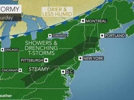
Then comes Saturday.
Find out what's happening in Ossining-Croton-On-Hudsonfor free with the latest updates from Patch.
There's already been a Hazardous Weather Outlook issued for Saturday across Orange, Putnam, Rockland and Westchester counties.
There is a threat for isolated strong to severe thunderstorms Saturday afternoon into evening ahead of an approaching cold front. Strong to damaging wind gusts and flash flooding will be the main threats with this activity.
For Dutchess and Ulster counties, the hazardous outlook is more detailed.
Find out what's happening in Ossining-Croton-On-Hudsonfor free with the latest updates from Patch.
There is a chance for non-severe thunderstorms today with the best potential for thunderstorm coverage to be north and west of Albany. Some of these thunderstorms may contain heavy rainfall. In addition, the combination of hot temperatures and increasing humidity levels will result in heat indices of lower 90s for valley locations.
The combination of hot temperatures and increasing humidity levels may produce dangerous heat conditions with heat indices into the low to mid 90s in portions of the Capital District and mid Hudson Valley again on Saturday. If confidence increases in heat indices of 95F or greater, then heat advisories will need to be issued.
In addition, isolated to scattered showers and thunderstorms are expected to become numerous to widespread areawide on Saturday. Heavy downpours are likely in any thunderstorm. Urban and poor drainage flooding and isolated flash flooding is possible.
"A surge of moisture and a slight southward dip in the jet stream will trigger a daily eruption of showers and thunderstorms," said Alex Sosnowski, AccuWeather senior meteorologist. Some areas can be hit with multiple downpours per day."
Get more local news delivered straight to your inbox. Sign up for free Patch newsletters and alerts.


