Weather
'Battle of the Seasons' Brings Rain, Snow, Cold To Hudson Valley
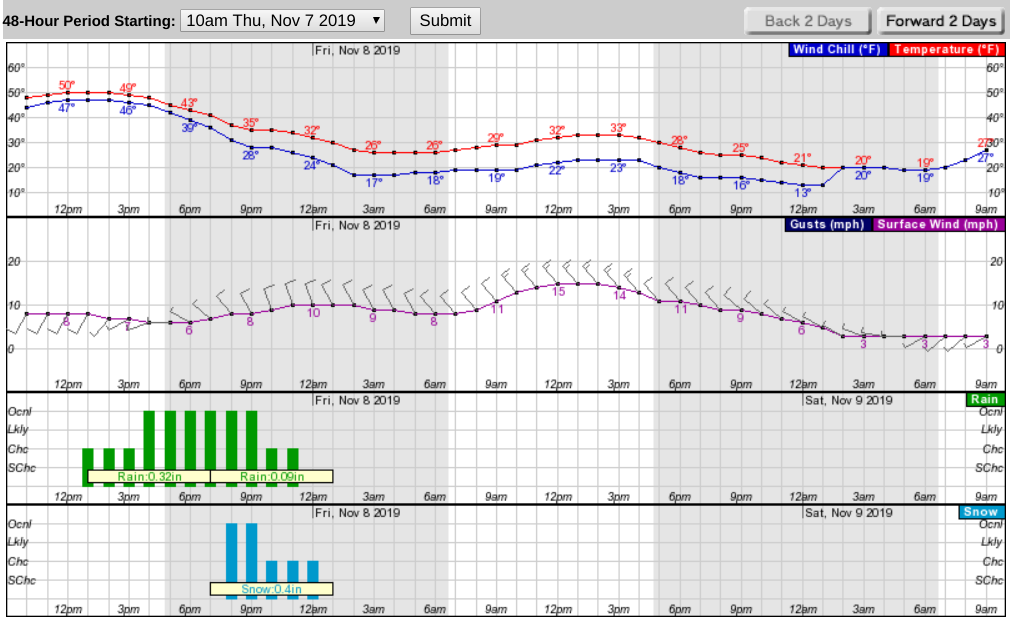
Plus a wind chill factor into the teens: here's an hour-by-hour look at the weather for Thursday and Friday.


HUDSON VALLEY — Arctic air — and we do mean air from the Arctic — will push rain and wet snow into the region ahead of it Thursday, forecasters say. The best chances for any accumulation at all will be away from the coast and at higher elevations.
The National Weather Service has issued a hazardous outlook for the mid Hudson, including Dutchess and Ulster counties.
Snow amounts of around an inch or less are expected for areas below 1500 feet elevation, with mainly 1 to 3 inches possible above 1500 feet. Low temperatures will fall below freezing tonight across the area, which could result in any residual moisture freezing on surfaces.
Hudson Valley Weather predicts that while some wet snow may fall south of I-84, the most we will get is some slush on the grass.
Find out what's happening in Ossining-Croton-On-Hudsonfor free with the latest updates from Patch.
"That’s what we’ll likely see on Thursday afternoon and evening… the battle of the seasons, between an autumn air mass and our first purely wintry airmass of the season," said Alex Marra and Bill Potter of Hudson Valley Weather.
Winds will shift and temperatures will drop as the frontal passage occurs, the National Weather Service said. The rain will end from northwest to southeast, with the entire area dry by sunrise Friday and temperatures struggling into the 30s.
Find out what's happening in Ossining-Croton-On-Hudsonfor free with the latest updates from Patch.
Here's what the next 48 hours look like for Putnam County:
Visit and "like" Mid-Hudson Valley Patch on Facebook.
Get more local news delivered straight to your inbox. Sign up for free Patch newsletters and alerts.