Weather
'Bomb Cyclone' Pounding the Hudson Valley
High winds could cause power outages across the region. Heavy wet snow is expected up-valley.


The 'bomb cyclone' nor'easter pounding New York is bringing a lot of precipitation to the Hudson Valley in addition to high winds. It dropped an inch of rain between when the storm began Thursday evening and 4:35 a.m., according to the National Weather Service.
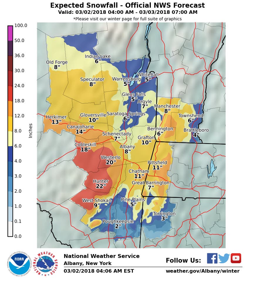
The mid-Hudson Valley is expecting from 4-12 inches of snow. The lower Hudson Valley is expecting high winds and heavy rain.
The heavy rainfall flooded I-95 in southern Westchester for a period of time before midnight. The NWS reminds commuters to expect some lane and even some roadway closures in flood prone areas to occur through the morning rush hour.
Find out what's happening in Ossining-Croton-On-Hudsonfor free with the latest updates from Patch.
A High Wind Warning in effect until 6 a.m. Saturday for Westchester and Rockland warns that the strongest winds will be this afternoon and tonight.
Damaging winds will blow down trees and power lines.Power outages are expected. Travel will be difficult, especially for high profile vehicles. Winds this strong can make driving difficult, especially for high profilevehicles, in open areas, and on elevated roads and bridges. Use extra caution. A High Wind Warning means a hazardous high wind event is expected or occurring. Sustained wind speeds of at least 40 mph or gustsof 58 mph or more can lead to property damage.
Meanwhile, school districts are beginning to react as the precipitation changes to snow up-valley.
Find out what's happening in Ossining-Croton-On-Hudsonfor free with the latest updates from Patch.
"As of the 4am hour, we’re already seeing the changeover occur. We have widespread reports from all over the Hudson Valley, that the dynamic cooling is having its impact," said Hudson Valley Weather.
The National Weather Service warns residents in the mid-Hudson Valley to plan on difficult travel conditions, including during the evening commute. North winds 20 to 30 mph with gusts up to 55 mph may bring down trees and powerlines. Be prepared for significant reductions in visibility at times. Any change in the track of the storm could result in much higher accumulations.
Here's the latest on warnings from the National Weather Service:
- A high wind warning has been expanded. It is in effect until 6 a.m Saturday for Rockland, Westchester
- Flood watch for Dutchess, Putnam, Rockland, Westchester, Ulster
- Coastal flood advisory for Westchester
- Winter Weather Advisory for Putnam, Ulster
- Winter Storm Warning for Dutchess, Orange

The strong winds could knock down tree limbs and cause power outages. O&R says it's ready for the storm, which is expected to undergo “bombogenesis." (Here's what that means.)
With a full moon Thursday, flooding is a primary concern for the area.
High winds from strong Nor'easter will impact Mid-Atlantic and New England ... GFS model update shows large area of 40-50 knot gusts over D.C. to Boston w/coastlines to see Hurricane Force Gusts (> 63 knots) as "bomb cyclone" intensifies and "occludes" (https://t.co/XcmEbEJxko) pic.twitter.com/lWBIaD2BNx
— Ryan Maue | weather.us (@RyanMaue) March 1, 2018
Here is a summary on the Major East Coast Storm that impacts the region tonight into Saturday. Watch the video! (Thursday Evening Update) pic.twitter.com/XDmKuK4slK
— NWS New York NY (@NWSNewYorkNY) March 2, 2018
SEE ALSO:
Get more local news delivered straight to your inbox. Sign up for free Patch newsletters and alerts.


