Weather
HV Conditions Ripe For Fire Spread, National Weather Service Warns
Plus, temperatures will drop into the 30s overnight; there's a freeze watch in effect for the mid-Hudson Valley.

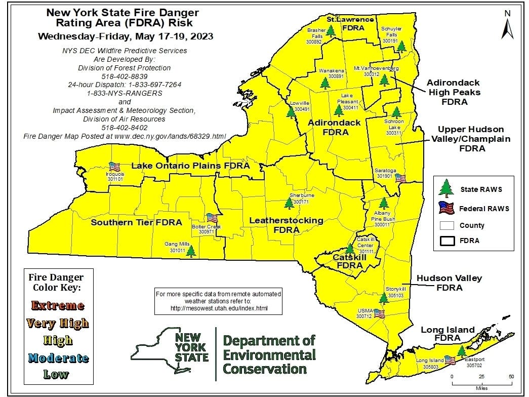
HUDSON VALLEY, NY — An elevated potential for fire spread exists Wednesday due to dry conditions and gusty winds. The National Weather Service put out a special statement for Orange, Putnam, Rockland and Westchester counties, saying, "Despite the recent green-up, these conditions may allow for elevated fire spread if ignition occurs."
Wind gusts to 25 mph are expected. Relative humidity values are below 25 to 30 percent.
Then temperatures will plummet overnight. There's a freeze watch in effect for Dutchess, Orange and Ulster counties. SEE: Freeze Watches Issued For Parts Of Mid-Hudson Valley
Find out what's happening in Ossining-Croton-On-Hudsonfor free with the latest updates from Patch.
The low could hit 32 degrees in Brewster, the mid-30s in northern Westchester, the upper 30s in Rockland County and the lower 40s in southern Westchester.
"The strong cold front sweeping down the East Coast will introduce cooler air to the region over the next couple of days ... with anomalies ranging between 15-25 degrees below average. Low temperatures hovering around freezing in the Northeast may tie or break records tonight," the National Weather Service said.
Find out what's happening in Ossining-Croton-On-Hudsonfor free with the latest updates from Patch.
That's while the West is experiencing anomalous heat, the NWS said. Temperatures are likely to
be between 20-25 degrees above average in many places, while the Pacific Northwest will experience the most anomalous warmth with highs in the 80s and 90s. Warm lows in the 50s and 60s may end up breaking records there through the weekend.
Get more local news delivered straight to your inbox. Sign up for free Patch newsletters and alerts.