
HUDSON VALLEY, NY — The National Weather Service has issued a hazardous weather outlook for Orange, Putnam, Rockland and Westchester counties.
"Our next chance for rain comes on Thursday and Friday, as another storm system… similar in some ways to our last storm from Sunday… takes aim on the eastern US," said Alex Marra and Bill Potter of Hudson Valley Weather.
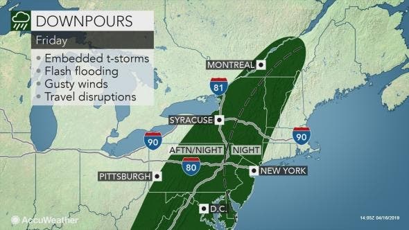
There is an increasing chance of minor to locally moderate coastal flooding with Thursday and Friday night high tides, the NWS said. It could also mean flooding rains Friday night into Saturday.
Find out what's happening in Ossining-Croton-On-Hudsonfor free with the latest updates from Patch.
"Anyone traveling through the Northeast ahead of the holiday weekend or to Good Friday events will face newly slick roads and limited visibility, so plans should include extra travel time," said Faith Eherts, AccuWeather meteorologist. "In general, the heaviest rounds of rain are expected to impact New York and the mid-Atlantic."
One of the other standout things about the weekend will be fluctuating temperatures, meteorologists predict.
Find out what's happening in Ossining-Croton-On-Hudsonfor free with the latest updates from Patch.
While temps will be in the mid 50s on Thursday, they will rise overnight to the 60s. Friday will be 10 degrees hotter than Thursday, with temps reaching 70 degrees. Saturday will be a little cooler and Sunday cooler still, with highs around 60.
Here's more on how the weekend is shaping up:
- Friday: unsettled, cloudy, windy, possible late-day thunderstorms; warm overnight with periods of rain and thunderstorms
- Saturday: showers depart, less windy; overnight mid 40s and clouds return
- Sunday: mostly cloudy, some showers possible
- Monday: mostly sunny, warmer
Get more local news delivered straight to your inbox. Sign up for free Patch newsletters and alerts.


