Weather
'Hit Or Miss' Storms Lead To Heavy Rain For the Hudson Valley
A hazardous weather outlook has been issued for the Mid-Hudson.

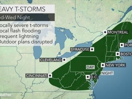
HUDSON VALLEY, NY — The National Weather Service has issued a hazardous weather outlook for Dutchess and Ulster counties. Tuesday's weather will be a set-up for Wednesday's downpours, meteorologists predict.
Tuesday afternoon and evening, thunderstorms are possible, and there's a 40 percent chance of rain. While most of the storms are not expected to be severe, an isolated storm or two may have the potential to produce damaging winds, the NWS said.
"So it’s going to be hit or miss storms," said Alex Marra and Bill Potter of Hudson Valley Weather. "Where a storm hits, you could get a quick inch of rain. But for most locations, you may hear some rumbling thunder in the distance… or some dark clouds over the horizon… but you end up staying dry. Either way, keep an eye to the sky later today."
Find out what's happening in Ossining-Croton-On-Hudsonfor free with the latest updates from Patch.
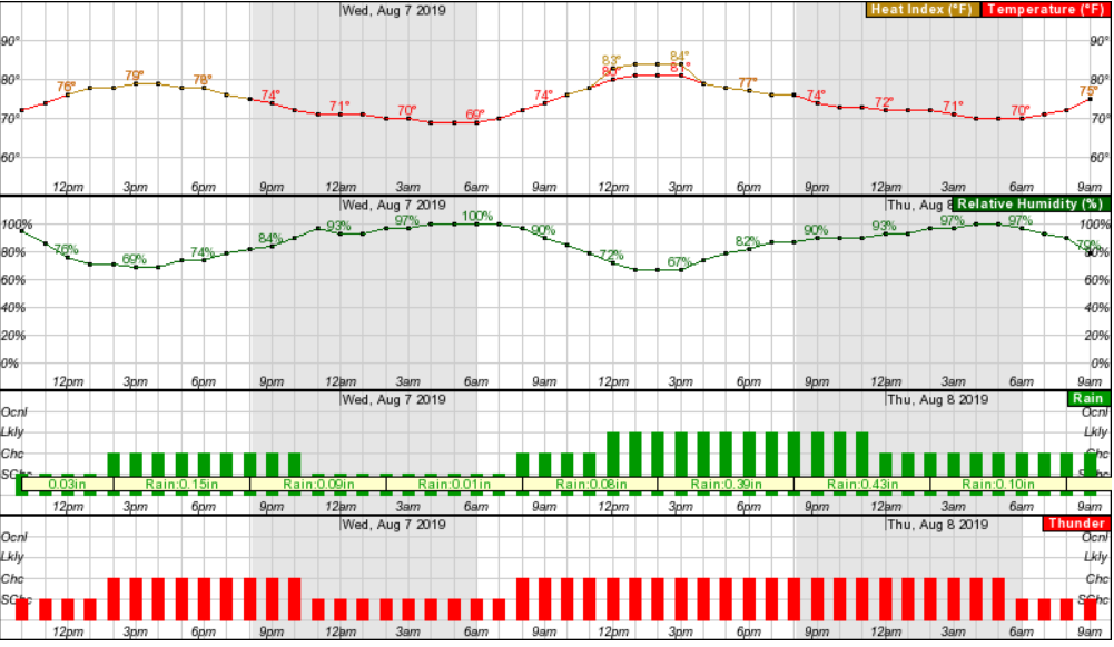
Then comes Wednesday, with a 70 percent chance of rain. The National Weather Service now forecasts a Marginal Risk for severe thunderstorms Wednesday, mainly for the afternoon and evening hours. The main threat would be damaging winds. Also, the heavy rainfall could lead to minor flooding of low lying, urban and poor drainage areas, especially Wednesday into Wednesday night. Isolated flash flooding is possible.
Here's what the NWS predicts for the next 48 hours:
Find out what's happening in Ossining-Croton-On-Hudsonfor free with the latest updates from Patch.
But there is some good news on the way.
"Since the air coming in is originating from north-central Canada, it will feel much less humid across much of the region spanning Thursday into Sunday," said Alex Sosnowski, AccuWeather senior meteorologist.
Get more local news delivered straight to your inbox. Sign up for free Patch newsletters and alerts.


