Weather
Hudson Valley: Winter Storm Warning Issued
We may see some rain at the start, but then heavy, wet snow. Here's the latest.


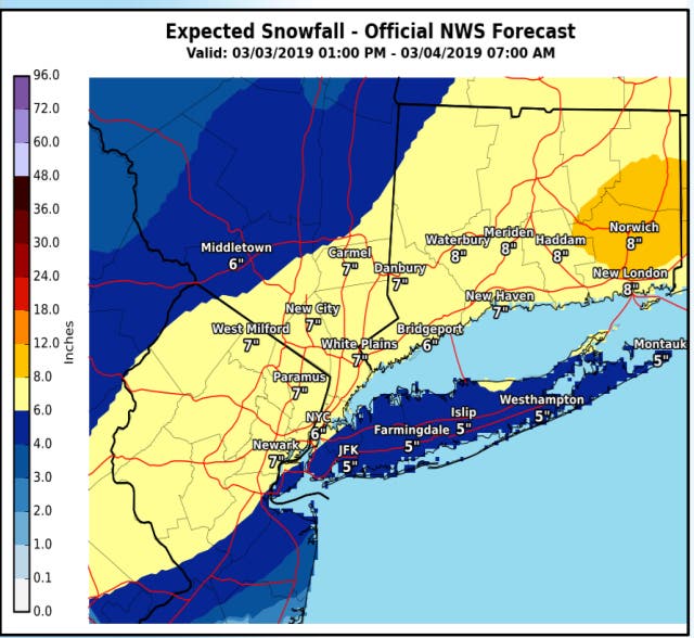
The National Weather Service has upgraded its advisory for Orange, Putnam, Rockland and Westchester counties to a winter storm warning. A snowfall of 5 to 8 inches is possible at the southern end of the valley.
Snow accumulation of 3 to 6 inches is expected in Dutchess and Ulster counties where a winter weather advisory was issued Sunday morning.
The approaching low will bring precipitation into the region possibly as early as this afternoon with light rain across the region, and maybe some snow and rain at the higher elevations of the lower Hudson Valley. As the low moves off the Mid Atlantic coast this evening snow will overspread the region, the NWS said.
Find out what's happening in Ossining-Croton-On-Hudsonfor free with the latest updates from Patch.
Once the snow starts, the NWS warns that we could see snowfall rates of up to 1-2 inches per hour. The heaviest snow is expected from 9 PM to 4 AM.
A warning also means the region could experience snow covered roads, difficult travel, and isolated to scattered power outages and downed tree limbs due to heavy wet snow.
Find out what's happening in Ossining-Croton-On-Hudsonfor free with the latest updates from Patch.
However, less then 12 hours away, there continues to be uncertainty with this storm.
A potential track closer to the coast could result in more mixing near the coast lowering amounts, while inland areas would have the potential for higher amounts, the NWS said. A track slightly farther south could result in the highest snow totals near the coast, and slightly lower totals across far northern sections.
Get more local news delivered straight to your inbox. Sign up for free Patch newsletters and alerts.


