Weather
Jose Not Going Away, Could Come Close Enough To Affect The Hudson Valley
Jose has weakened to a tropical storm, but it's expected to regain steam, and that raises the threat of local impacts. Meanwhile, we're hot.


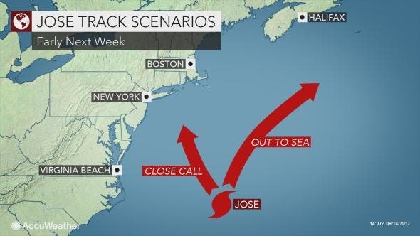
Jose remains likely to stay offshore, but its track has shifted west, and it could come close enough to affect New York next week, the National Weather Service says. Wind, rain and coastal flood impacts are not out of the question come Tuesday and Wednesday. Certainly rough surf will persist all the way up to Massachusetts into next week, so if you like heading to the beach once the crowds have thinned out, take care.
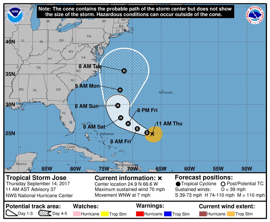
The storm, currently located about 435 miles east-northeast of the Bahamas, weakened to a tropical storm Thursday morning with sustained winds of 70 mph, but it's expected to restrengthen into a hurricane by Friday night.
"For now, Jose is well out to sea, and not expected to cause much trouble for the next several days," said Bill Potter of Hudson Valley Weather. "However, after the trough left over from Irma pushes east… it should make room for Jose to push north. Exactly where atmospheric features set up in 5 to 7 days, will determine if Jose gets pushed out to sea harmlessly… or dragged back to the west. If it’s dragged back toward the US coast… it could be ripped apart by wind shear. So we need to keep watch for now… but Jose is looking more like a headache than a threat."
Find out what's happening in Ossining-Croton-On-Hudsonfor free with the latest updates from Patch.
Watch: Hurricanes Jose And Irma Seen From Space
In a forecast discussion released at 11 a.m Thursday, the National Hurricane Center says: "A trough currently over the Lower Mississippi Valley into the northwestern Gulf of Mexico is expected to play a key role in how close Jose comes to the eastern United States. Some of the model solutions show the trough tugging on the tropical cyclone, causing a more north-northwestward motion at the end of the period, while others have the trough deflecting the cyclone more out to sea."
Find out what's happening in Ossining-Croton-On-Hudsonfor free with the latest updates from Patch.
There's a chance the storm could stall off the Northeast coast for a time next week, according to AccuWeather.
“A persistent onshore flow in some locations may lead to coastal flooding at times of high tide for many days even if Jose remains a few hundred miles offshore,” AccuWeather Senior Meteorologist Alex Sosnowski said.
Meanwhile, we're hot.
Written by Ryan Bonner. Patch Editor Lanning Taliaferro contributed to this report.
Get more local news delivered straight to your inbox. Sign up for free Patch newsletters and alerts.