Weather
New Hazardous Outlooks For Hudson Valley Counties Wednesday
Here's when and where severe weather will be most likely Wednesday.

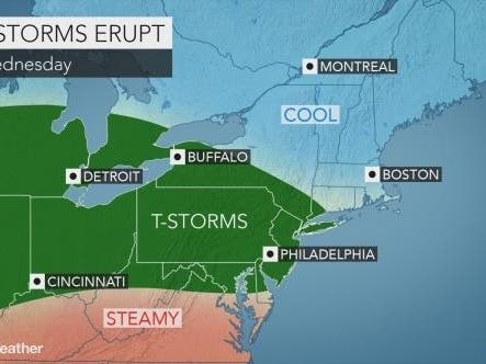
The severe thunderstorms and tornadoes that crossed New Jersey and threatened Staten Island missed the Hudson Valley on Tuesday night. But more storms are coming, and the National Weather Service issued a hazardous weather outlook for Orange and Rockland counties warning of severe weather Wednesday afternoon and evening.
There is a chance of strong to severe thunderstorms developing late this afternoon into this evening. The main threat will be damaging winds and large hail, however, an isolated tornado is possible. Localized flooding is possible as well. The threat is highest just west of the NYC metro. Monitor subsequent NWS forecasts for the latest information on this severe threat.
The NWS issued a hazardous weather outlook for Dutchess and Ulster counties too:
Find out what's happening in Ossining-Croton-On-Hudsonfor free with the latest updates from Patch.
There is a Marginal Risk for strong to isolated severe thunderstorms late this afternoon into the early evening with large hail and damaging winds the main threats.
While Putnam and Westchester counties are also expected to experience thunderstorms that may produce gusty winds, small hail, and heavy rainfall this afternoon, the NWS has not put out any advisory for those areas.
Storms or not, "all the ingredients needed for heavy rain are in place," said Alex Marra and Bill Potter of Hudson Valley Weather.
Find out what's happening in Ossining-Croton-On-Hudsonfor free with the latest updates from Patch.
Severe weather would be most likely between 4 and 8 p.m., they said.
The National Weather Service is sending officials to Sussex County, New Jersey on Wednesday conducting a storm survey; they confirmed a tornado touched down near Morgantown in Berks County, Pennsylvania.
The severe weather into Thursday will ignite as a significant temperature contrast sets up across the eastern United States.
"Parts of the Ohio Valley and mid-Atlantic will be stuck in the battle zone between extreme heat in the Southeast and cool, maritime air in the Northeast," according to according to AccuWeather Senior Meteorologist Brett Anderson.
Get more local news delivered straight to your inbox. Sign up for free Patch newsletters and alerts.


