Weather
Next Storm Will Bring 2+ Inches Of Snow, Sleet: Hudson Valley Forecast
A hazardous outlook has already been issued for the mid-Hudson and a winter storm watch for western Ulster County.


UPDATE 4:15 p.m. — Winter Weather Advisories Issued For Dutchess, Orange, Putnam, Ulster
HUDSON VALLEY, NY — Another storm is bearing down on the region — a hazardous outlook has been issued for Dutchess and Ulster counties — but the snow it's bringing could be overwhelmed by rain.
The first storm of the week brought rain and heavy bands of snow on Monday and caused problems for schools and commuters in the mid-Hudson. Ditto for the next one, which is expected to bring snow, sleet, rain and freezing rain Wednesday into Thursday.
Find out what's happening in Ossining-Croton-On-Hudsonfor free with the latest updates from Patch.
"Temperatures are projected to be in the upper 20s to around 30° when the snow moves in, and should begin to accumulate on all surfaces. In addition, the timing of the snow arrival appears to be late morning. This will cause have impacts on travel, so school cancellations or early releases appear likely on Wednesday," said Bill Potter of Hudson Valley Weather. "Unfortunately for snow lovers, this system is very likely to transition to rain before ending late Wednesday night."
For the interior of the Hudson Valley, snow will develop early Wednesday afternoon becoming moderate to heavy through the evening hours, affecting the commute. Snowfall rates of 1/2 to 1 inch per hour are possible. Peak winds could gust to 40 mph. Snow covered roads and poor visibility will lead to difficult travel. A wintry mix of precipitation including freezing rain and sleet is expected to develop Wednesday night into Thursday morning.
Find out what's happening in Ossining-Croton-On-Hudsonfor free with the latest updates from Patch.
Still, the storm may not end the snow drought plaguing New York south of the mid-Hudson.
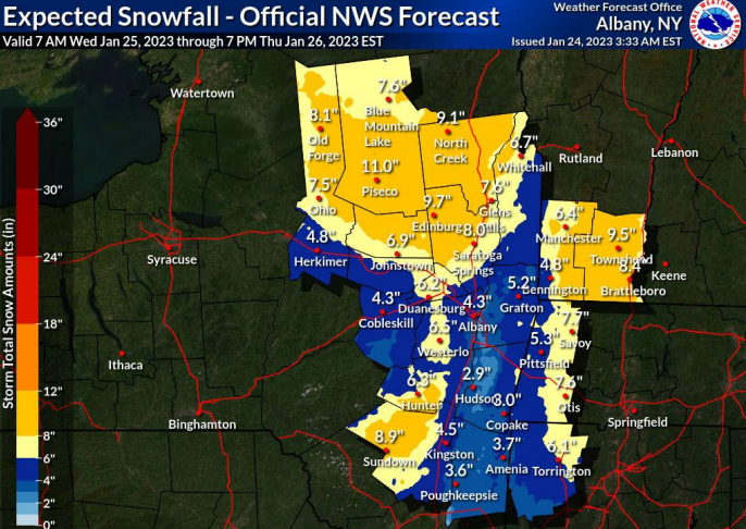
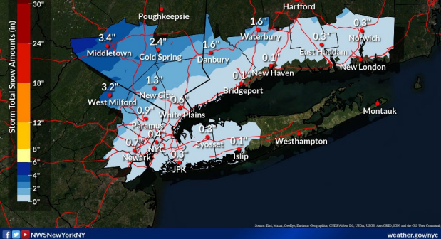
While the National Weather Service predicts 2-5 inches of snow for Orange County, 4-9 inches for western Ulster, 2-4 inches for western Dutchess and eastern Ulster, and 1-3 inches for Rockland, Putnam and northern Westchester, the forecast is for less than an inch in southern Westchester — which might instead suffer from moderate coastal flooding.
The storm will end with rain.
"The cold air associated with the storm is set to swoop into the I-95 corridor by Thursday. However, by this time, the storm and most of its precipitation are likely to shift over northern New England, minimizing the chances of snowflakes," said Courtney Travis, AccuWeather senior meteorologist. "During the day on Thursday, the most difficult travel is likely to be confined to northern New York, Vermont, New Hampshire and Maine, including parts of interstates 87, 89, 91 and 93."
Even in western Ulster, the storm is expected to run the gamut from snow to sleet and freezing rain before temperatures rise above freezing and the storm turns to rain as it moves off.
The warmer air and moisture will come all the way from the Gulf of Mexico, the National Weather Service said.
What's going on?
"From Oct. 1, 2022, through Sunday, Jan. 22, New York City, Philadelphia and Washington, D.C., have received only trace amounts of snowfall, a vast departure from the typical accumulation during that timespan," said Thomas Leffler, AccuWeather staff writer.
Temperatures across the I-95 corridor are the top reason for the lack of snow. Temperatures on New Year's Eve maxed out nearly 15 degrees above average. In January, average temperatures are running at least 8 degrees higher than normal.
AccuWeather meteorologists predict above-normal temperatures will continue into February.
Here's the five-day forecast from the National Weather Service, based on Putnam County:
Tuesday - Partly sunny. Highs in the upper 30s. West winds 10 to 15 mph with gusts up to 25 mph.
- Tonight - Partly cloudy. Lows in the mid 20s. West winds 5 to 10 mph.
- Wednesday - Cloudy. A chance of snow in the morning, then snow and rain in the afternoon. Highs in the mid 30s. East winds around 5 mph, increasing to southeast 15 to 20 mph with gusts up to 30 mph in the afternoon. Chance of precipitation 50 percent.
- Wednesday Night - Rain and snow in the evening, then rain likely after midnight. Light snow accumulation. Breezy with lows in the mid 30s. Southeast winds 20 to 25 mph, becoming south 15 to 20 mph after midnight. Gusts up to 35 mph. Chance of precipitation near 100 percent.
- Thursday - Mostly cloudy. A chance of rain showers in the morning. Highs in the lower 40s. West winds 15 to 20 mph with gusts up to 35 mph. Chance of rain 30 percent.
- Thursday Night - Mostly cloudy in the evening, then becoming partly cloudy. Lows in the lower 20s.
- Friday - Mostly sunny. Highs in the lower 30s.
- Friday Night - Partly cloudy in the evening, then becoming mostly cloudy. Lows in the lower 20s.
- Saturday - Partly sunny. Highs in the lower 40s.
- Saturday Night - Partly cloudy in the evening, then becoming mostly cloudy. Lows in the mid 20s.
Get more local news delivered straight to your inbox. Sign up for free Patch newsletters and alerts.