Weather
Winter Weather Advisories Issued For Dutchess, Orange, Putnam, Ulster
Plan on slippery road conditions as 1 inch per hour snowfall rates are possible Wednesday afternoon into early evening.


UPDATE — Winter weather advisories were expanded as of Tuesday evening to include Rockland County and northern Westchester.
HUDSON VALLEY, NY — The National Weather Service has issued winter weather advisories for Dutchess, Orange, Putnam and Ulster counties ahead of the massive storm from the Southwest that is expected to affect the East Coast.
For Dutchess and Ulster: The warning goes into effect at 7 a.m. and expires at 10 p.m. Wednesday. Mixed precipitation is expected. Snowfall rates will be as high as one inch per hour on Wednesday afternoon and early evening. Total snow accumulations of 2 to 4 inches will be topped by a light glaze of ice. Winds could gust as high as 40 mph, especially for the higher elevations. Expect slippery road conditions to affect the afternoon and evening commute on Wednesday.
Find out what's happening in Southeast-Brewsterfor free with the latest updates from Patch.
For Orange County: The warning goes into effect at 7 a.m. and expires at midnight Wednesday. Snow and mixed precipitation are expected. Total snow accumulations of 2 to 5 inches, but locally 6 inches of snow is possible across the highest elevations. Ice accumulations of a light glaze. One inch per hour snowfall rates possible Wednesday afternoon into early evening. Plan on slippery road conditions.
For Putnam County: The warning goes into effect at 10 a.m. and expires at midnight Wednesday. Snow and mixed precipitation are expected. Total snow accumulations of 2 to 3 inches and ice accumulations of a light glaze are possible, with winds gusting as high as 35 mph. Plan on slippery road conditions.
Find out what's happening in Southeast-Brewsterfor free with the latest updates from Patch.
The snow will turn to a wintry mix and/or rain Wednesday night.
For Rockland and Westchester counties, there is a chance of a little snow Wednesday morning, then snow, rain and sleet in the afternoon. Snow and sleet accumulation could be 1 to 3 inches. However, rain with a chance of freezing rain is forecast in the evening, turning to all rain overnight. There's a chance of thunderstorms in southern Westchester, where the high on Wednesday will be in the lower 40s.
"The potential for this storm to have a negative impact on travel is significant and from a flight standpoint alone is likely to be the most disruptive since a month earlier during the Christmastime Arctic cold and snow outbreak," AccuWeather Senior Meteorologist Alex Sosnowski said.
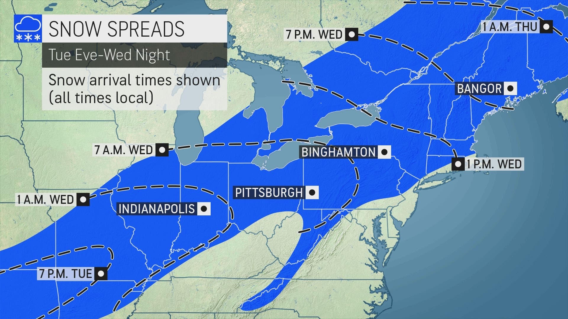
A wide swath of 3-6 inches of snow is expected from southern Missouri to Pennsylvania and New York to Maine, AccuWeather reported. The heaviest snowfall will pile up from northern New York to interior parts of Maine, where a foot or more will accumulate.
Get more local news delivered straight to your inbox. Sign up for free Patch newsletters and alerts.


