Weather
Risk Of Severe Storms With Winds, Hail, Tornado In The Hudson Valley
Hazardous outlooks say the heaviest rainfall could lead to urban or poor drainage flooding and localized flash flooding. Here's the latest.

UPDATE 5:30 p.m. Severe Thunderstorm Warning For Parts Of Hudson Valley
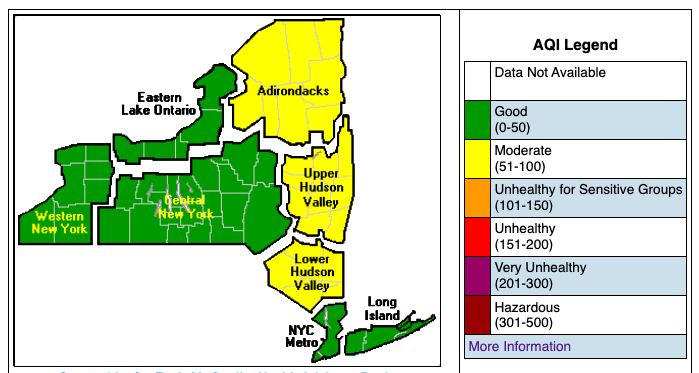
HUDSON VALLEY, NY — Monday kicked off with muggy air (more polluted in Putnam, Orange, Dutchess and Ulster counties) and hazardous outlooks issued across the Hudson Valley by the National Weather Service.
"Dangerous weather is forecast to sweep through the East Coast, with some areas of the Northeast expected to be at risk for severe weather for multiple days," said Courtney Travis, AccuWeather senior meteorologist.
Find out what's happening in Ossining-Croton-On-Hudsonfor free with the latest updates from Patch.
While the highest risk for severe storms runs from Richmond to Newark, the Storm Prediction Center has placed the Hudson Valley at a slight risk for severe thunderstorms, mainly in the afternoon and evening. The biggest threats are damaging wind gusts and hail, but an isolated tornado cannot be ruled out, the NWS said.
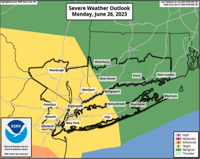
- Damaging wind gusts: Isolated to scattered damaging wind gusts in excess of 58 mph. The greatest threat lies across the Lower Hudson Valley, northeastern New Jersey, NYC, western Long Island, and southwestern Connecticut.
- Large hail: Localized 1” diameter hail possible.
- Isolated tornado: Low risk for an isolated tornado across the lower Hudson Valley and northeastern New Jersey
- Timing: Mainly this afternoon through around 10 p.m.
"Along with the severe weather threat, will come the potential for a good amount of rainfall," said Bill Potter of Hudson Valley Weather.
Find out what's happening in Ossining-Croton-On-Hudsonfor free with the latest updates from Patch.
What's still uncertain, the NWS said: how widespread the threat for severe storms will be, especially east of the Hudson River corridor, and where the heaviest rainfall could lead to urban and poor drainage flooding and localized flash flooding.
Utility companies are preparing to mobilize emergency response teams to repair potential damage and restore possible power outages. O&R officials said a heavy thunderstorm could pose a significant threat to electric service because its associated high winds and lightning strikes contribute to downing trees, tree limbs and overhead electric lines — all of which could interfere with the safe, reliable delivery of electric service. A line of heavy thunderstorms would represent an even more serious potential risk.
The air quality was only moderate in most of the Hudson Valley Monday morning, with fine particulates the cause. "Moderate" air quality is acceptable; however, there may be a health concern for a very small number of people who are unusually sensitive to air pollution.
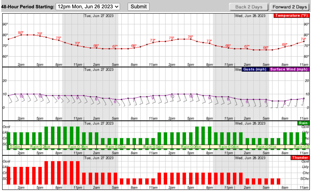
There will be additional chances for showers and storms Tuesday and Wednesday, and then again late week into next weekend, the National Weather Service said.
"As the week progresses, thunderstorms could once again be feisty on Tuesday," Travis said.
Locally heavy rain is possible during thunderstorms. Should storms repeatedly affect a given area, isolated flash flooding is possible.
"Several inches of rain appear possible across the Hudson Valley by the end of the first week of July ... which is great news for the Hudson Valley," Potter said.
Here's the 5-day forecast based on northern Westchester:
- Monday - Mostly cloudy. Showers likely with a chance of thunderstorms late this morning, then showers and thunderstorms likely this afternoon. Some thunderstorms may produce gusty winds and heavy rainfall this afternoon. Highs in the lower 80s. Southeast winds 5 to 10 mph. Gusts up to 20 mph this afternoon. Chance of rain 70 percent.
- Tonight - Showers and thunderstorms in the evening, then showers likely with a chance of thunderstorms after midnight. Some thunderstorms may produce gusty winds and heavy rainfall in the evening. Humid with lows in the mid 60s. Southeast winds 5 to 10 mph. Gusts up to 20 mph in the evening. Chance of rain 80 percent.
- Tuesday - Mostly cloudy. A chance of showers with a slight chance of thunderstorms in the morning, then showers likely with a chance of thunderstorms in the afternoon. Humid with highs in the upper 70s. South winds 5 to 10 mph. Gusts up to 20 mph in the afternoon. Chance of rain 70 percent.
- Tuesday Night - Showers with a chance of thunderstorms. Lows in the mid 60s. South winds 5 to 10 mph. Gusts up to 20 mph in the evening. Chance of rain 80 percent.
- Wednesday - Showers likely with a slight chance of thunderstorms in the morning, then showers likely with a chance of thunderstorms in the afternoon. Humid with highs in the upper 70s. South winds 5 to 10 mph. Chance of rain 70 percent.
- Wednesday Night - Mostly cloudy. Showers likely with a chance of thunderstorms in the evening, then a chance of showers after midnight. Lows in the lower 60s. Chance of rain 70 percent.
- Thursday - Partly sunny. Showers likely with a chance of thunderstorms in the afternoon. Highs in the upper 70s. Chance of rain 60 percent.
- Thursday Night - Mostly cloudy. A chance of thunderstorms in the evening. Lows in the lower 60s. Chance of precipitation 50 percent.
- Friday - Partly sunny. A chance of showers in the afternoon. Highs around 80. Chance of rain 40 percent.
- Friday Night - Mostly cloudy. A chance of showers in the evening. Lows in the lower 60s. Chance of rain 40 percent.
Here's the next 48 hours at a glance:
Get more local news delivered straight to your inbox. Sign up for free Patch newsletters and alerts.


