Weather
From Shorts To Sweaters: Hudson Valley Forecast
When can we expect the danger of a spring freeze to pass?


HUDSON VALLEY, NY — Cold air continues to flow into the region, along with scattered showers. AccuWeather and other forecasters say Tuesday will be the chilliest day of this week for the Hudson Valley and, in fact, much of the Northeast.
"Temps will be much cooler, with highs in the mid to upper 50s ... a far cry from the record high of 91° in Poughkeepsie on Friday," Bill Potter of Hudson Valley Weather said on Facebook.
The previous record high in Poughkeepsie for April 14 was 84 — set last year, according to HVW.
Find out what's happening in Ossining-Croton-On-Hudsonfor free with the latest updates from Patch.
The warm wave was widespread.
"Dozens of daily high-temperature records were broken, or even shattered, from Minneapolis to Boston between Thursday and Friday last week.," Mary Gilbert, AccuWeather meteorologist. "The mercury in New York City soared to 90 F on Thursday and 91 F Friday, which set new high-temperature records for each day. In fact, the last time the Big Apple hit 90 F or more on consecutive days in April was more than two decades ago, from April 16-18, 2002."
Find out what's happening in Ossining-Croton-On-Hudsonfor free with the latest updates from Patch.
Roller-coaster temperatures will continue, as we will spend the first part of the week in the 50s and the end of the work week in the 70s.
If the warmth kicked your urge to plant more than pansies into high gear, you'll appreciate the handy “Day of the Last Spring Freeze” map from the National Oceanic and Atmospheric Administration, which is derived from the 1991–2020 U.S. Climate Normals.
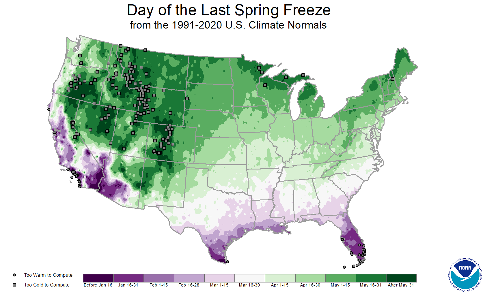
The bottom line: wait until the end of the month.
Here's the 5-day forecast from the National Weather Service, based on northern Westchester:
- Monday night - Partly cloudy. Lows in the mid 40s. West winds 5 to 10 mph. Gusts up to 20 mph in the evening.
- Tuesday - Partly sunny. Highs in the mid 50s. West winds 10 to 15 mph with gusts up to 25 mph.
- Tuesday Night - Mostly cloudy in the evening, then becoming partly cloudy. Lows in the upper 30s. West winds 5 to 10 mph. Gusts up to 20 mph in the evening.
- Wednesday - Sunny. Highs in the upper 50s. West winds 5 to 10 mph with gusts up to 20 mph.
- Wednesday Night - Mostly clear in the evening, then becoming partly cloudy. Lows around 40.
- Thursday - Mostly sunny. Highs in the upper 60s.
- Thursday Night - Partly cloudy. Lows in the upper 40s.
- Friday - Mostly sunny. Highs in the upper 70s.
- Friday Night - Mostly cloudy with a 40 percent chance of showers. Lows in the mid 50s.
- Saturday - Mostly cloudy in the morning, then becoming partly sunny. A 50 percent chance of showers. Highs in the lower 70s.
Get more local news delivered straight to your inbox. Sign up for free Patch newsletters and alerts.