Weather
Storm To Bring Rain, Freezing Drizzle, Snow: Hudson Valley Forecast
The lethal West Coast storm will bring precipitation to our region from Wednesday to Saturday.


HUDSON VALLEY, NY — Cloudy but dry isn't going to last long in the Hudson Valley, with that old wintry mix returning to the region Wednesday and lingering as a massive storm system pushes across the country.
It's the same storm now causing an atmospheric river in California, where a series of storms since the turn of the year have caused 14 deaths, AccuWeather reported.
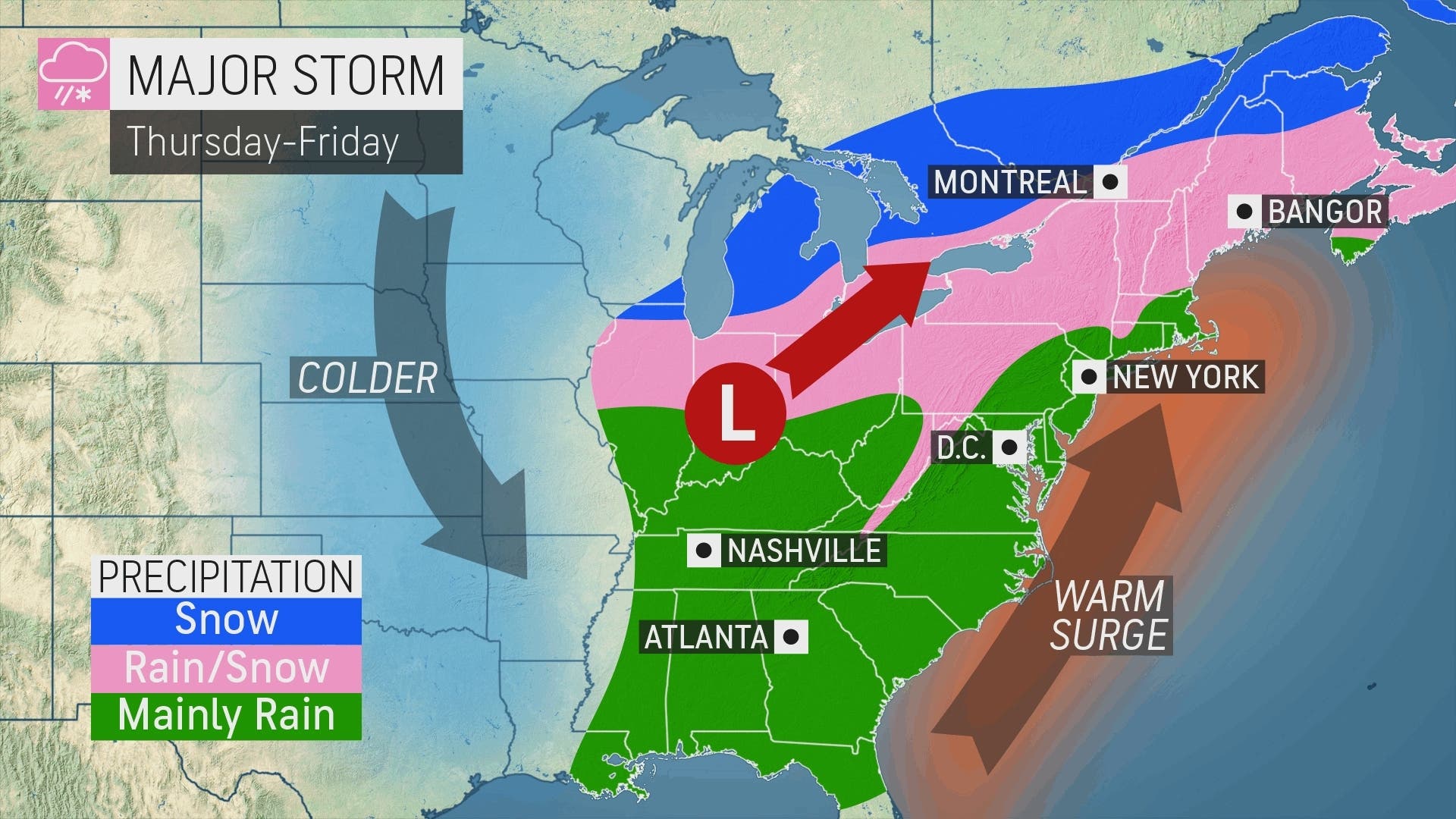
It's expected to bring severe weather in the South and pockets of sleet, freezing rain and snow to the Midwest and upstate New York as it approaches the mid-Atlantic.
Find out what's happening in Ossining-Croton-On-Hudsonfor free with the latest updates from Patch.
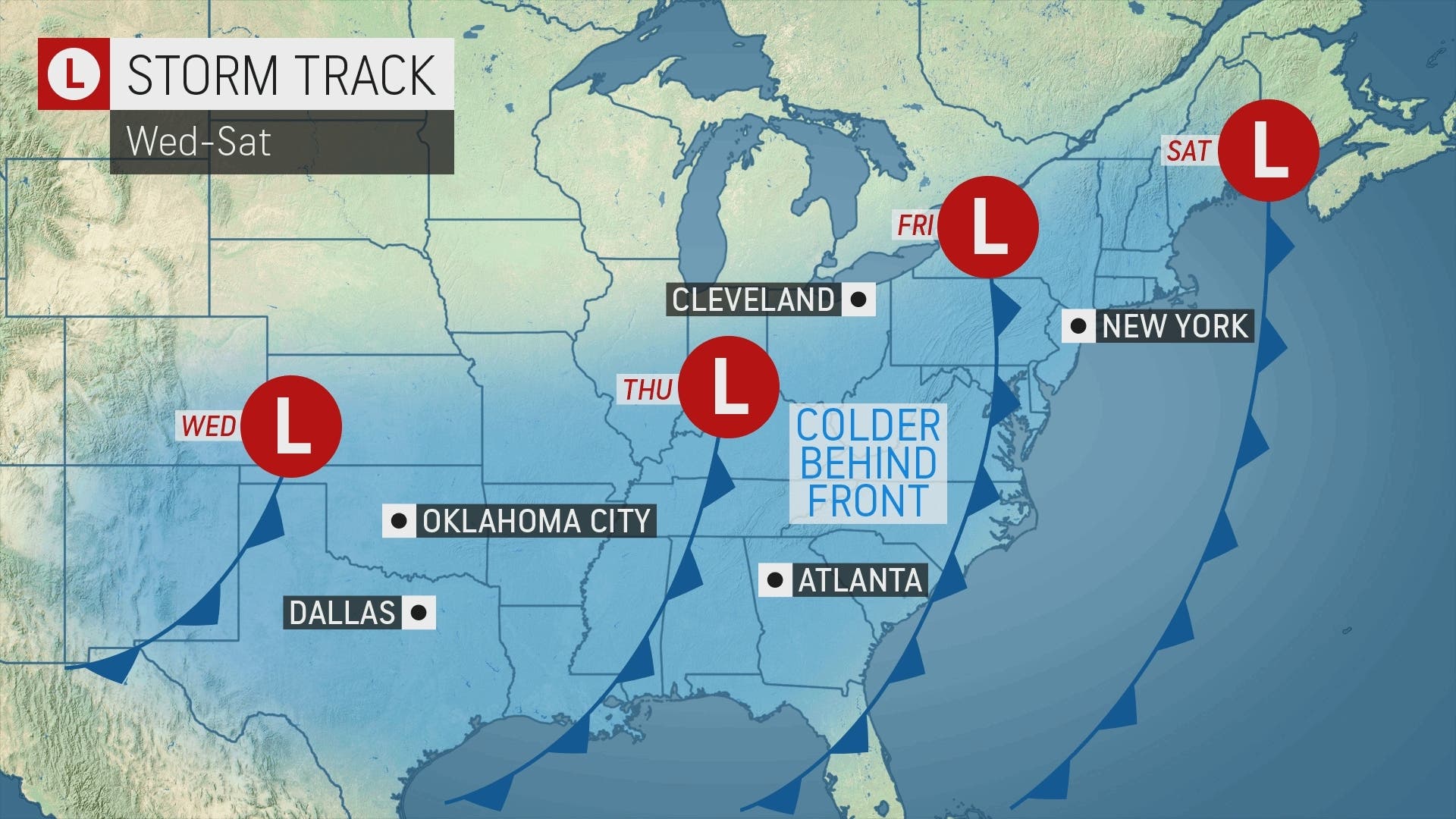
"Heavy rain and wind will be the most ubiquitous troublemakers, threatening a slew of travel delays, and the storm will also have a wintry side," said Alex Sosnowski, AccuWeather senior meteorologist.
However, though snow is expected from northeastern Ontario through far northern New England into Friday morning, the storm will bring mostly rain to vast stretches of heavily traveled interstates, including I-80 and I-95, he said.
Find out what's happening in Ossining-Croton-On-Hudsonfor free with the latest updates from Patch.
A secondary storm could develop along the Atlantic coast as colder air sweeps in at the end of the week. "Should the storm strengthen at a fast pace, it could draw in just enough cold air to produce a stripe of snow from near the Hudson Valley of New York to New England, perhaps including New York City and Boston, on Friday night," he said.
However, chances are slim, meteorologists agreed.
"We continue to watch the late week for our next storm system," said Bill Potter of Hudson Valley Weather. "Temperatures appear likely to be too mild for any significant snow accumulation in the Hudson Valley."
The National Weather Service offers this forecast based on northern Westchester:
- Tuesday - Mostly cloudy. Highs in the lower 40s. West winds 5 to 10 mph.
- Tonight - Mostly cloudy. Lows in the mid 20s. North winds around 5 mph.
- Wednesday - Partly sunny. Highs in the upper 30s. East winds around 5 mph.
- Wednesday Night - Mostly cloudy. A slight chance of freezing drizzle and snow after midnight. Lows in the lower 30s. East winds around 5 mph. Chance of precipitation 20 percent.
- Thursday - Cloudy. A slight chance of rain showers in the morning, then a chance of rain in the afternoon. Highs in the lower 50s. Southeast winds 5 to 10 mph. Gusts up to 20 mph in the afternoon. Chance of rain 40 percent.
- Thursday Night - Rain. Lows in the mid 40s. Chance of rain 90 percent.
- Friday - Rain likely, mainly in the morning. Highs in the lower 50s. Chance of rain 70 percent.
- Friday Night - Mostly cloudy with a 50 percent chance of rain. Lows in the mid 30s.
- Saturday - Mostly cloudy. A chance of rain in the morning, then a chance of rain and snow in the afternoon. Highs in the lower 40s. Chance of precipitation 40 percent.
- Saturday Night - Mostly cloudy in the evening, then becoming partly cloudy.
Get more local news delivered straight to your inbox. Sign up for free Patch newsletters and alerts.