Weather
Stormy Weekend Forecast For The Hudson Valley
A hazardous outlook has been issued for part of the region. Here's the latest.

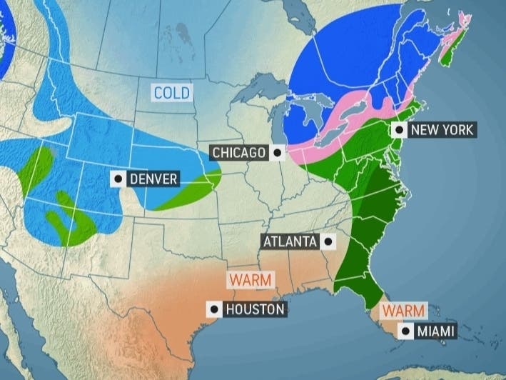
HUDSON VALLEY, NY — After that lovely start to spring, the region is in for stormy weather, possible flooding and temperatures more suitable to March.
In Dutchess and Ulster counties, the combination of snow melt and rainfall Thursday will result in rises on some smaller streams and rivers. A few river points within smaller river basins may approach flood stage Thursday night into Friday, the National Weather Service said.
Friday won't be particularly rainy, but then a storm system from the center of the country is expected to bring rain, a wintry mix or even snow to the region Saturday into early Sunday.
Find out what's happening in Ossining-Croton-On-Hudsonfor free with the latest updates from Patch.
"Showers and thunderstorms, mainly associated with the storm's cold front, will sweep eastward from Friday evening to Saturday. Some of the storms could become locally heavy and gusty," said Alex Sosnowski, AccuWeather senior meteorologist.
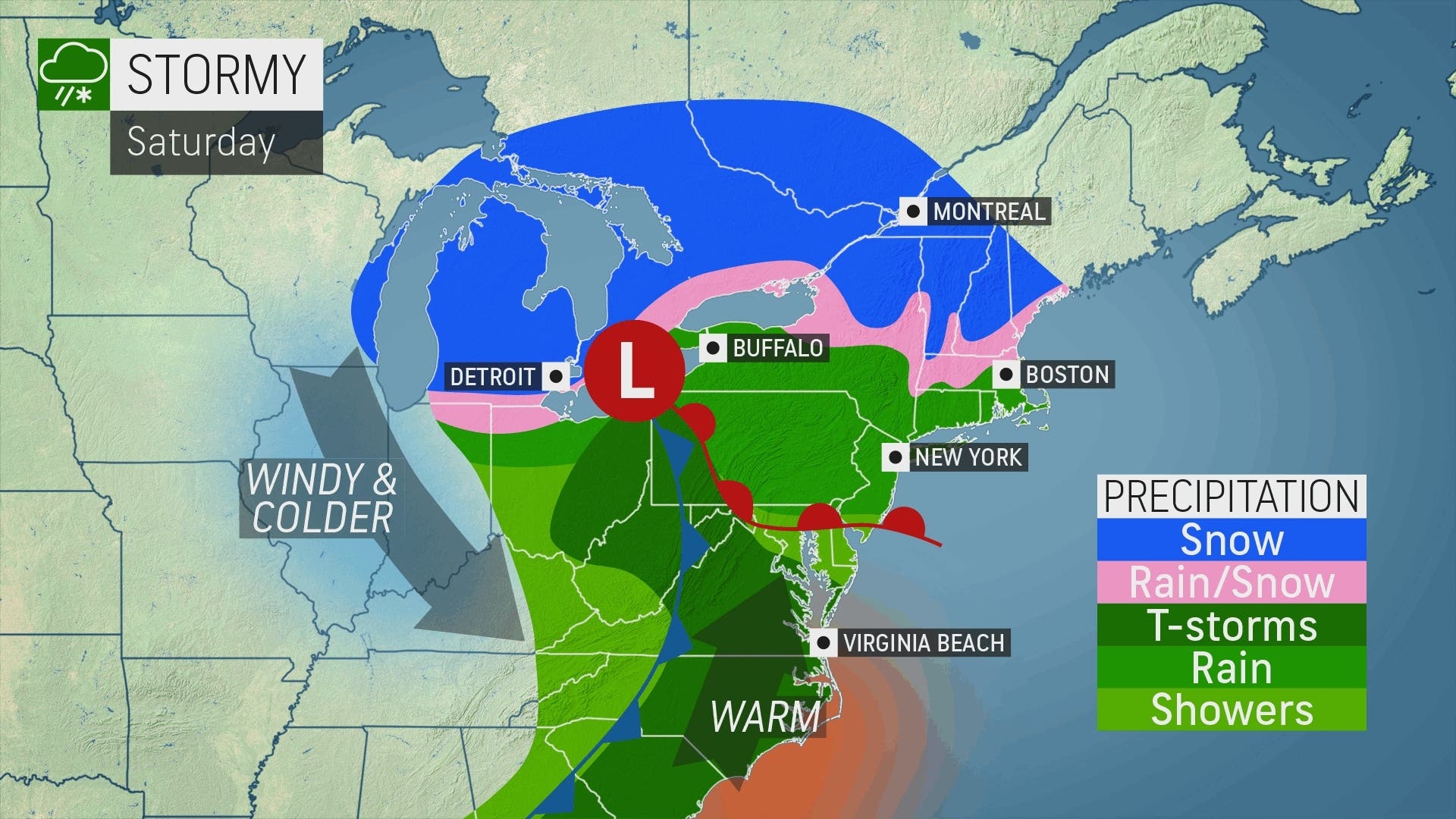
Across the region, flight delays and some flight cancellations could be possible Saturday, Sosnowski said.
Find out what's happening in Ossining-Croton-On-Hudsonfor free with the latest updates from Patch.
Recent snowfall has brought snowpack to near or even above normal levels for this time of year across eastern New York. Snowpack in the Catskills, for example, increased dramatically to 4 up to 29 inches in depth, with liquid equivalents measured from 0.3 to 5.3 inches, the National Weather Service said. While the snowmelt flood threat is low this week in the mid-Hudson, it could rise next week.
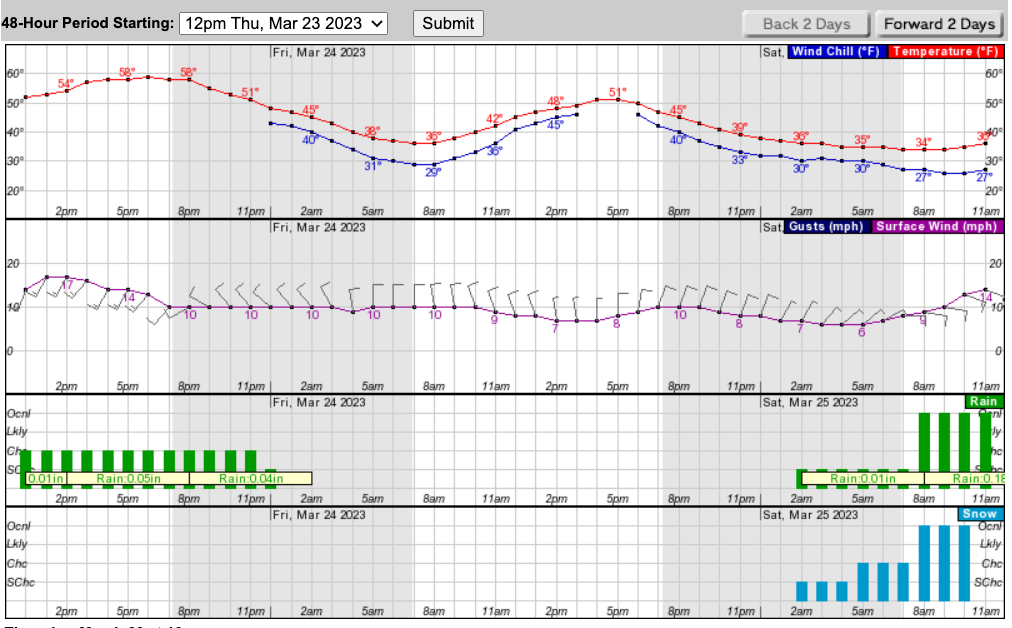
Here's a look at the next 48 hours for Poughkeepsie from the NWS:
Here's the 5-day forecast for northern Westchester:
- Thursday - Cloudy with a 50 percent chance of showers. Highs around 60. Southwest winds 10 to 15 mph with gusts up to 25 mph.
- Tonight - Mostly cloudy. Showers likely, mainly in the evening. Lows in the upper 30s. West winds 10 to 15 mph, becoming northwest after midnight. Gusts up to 25 mph. Chance of rain 60 percent.
- Friday - Mostly cloudy. Highs in the lower 50s. Northwest winds 5 to 10 mph. Gusts up to 20 mph in the morning.
- Friday Night - Mostly cloudy. A chance of showers after midnight. Lows in the upper 30s. North winds 5 to 10 mph. Chance of rain 40 percent.
- Saturday - Rain showers with a slight chance of snow showers in the morning, then rain showers in the afternoon. Little or no snow accumulation. Highs in the mid 40s. East winds 15 to 20 mph with gusts up to 30 mph. Chance of precipitation near 100 percent.
- Saturday Night - Showers, mainly in the evening. Lows around 40. Chance of rain near 100 percent.
- Sunday - Mostly sunny. Highs in the mid 50s.
- Sunday Night - Mostly clear. Lows in the mid 30s.
- Monday - Partly sunny. Highs in the mid 50s.
- Monday Night - Mostly cloudy with a 40 percent chance of rain. Lows in the upper 30s.
Get more local news delivered straight to your inbox. Sign up for free Patch newsletters and alerts.


