Weather
Tropical Storm Erin: Hudson Valley To Feel Impacts
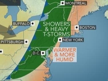
Showers and storms are possible as Erin meets a cold front from the west.

The remnants of Tropical cyclone Erin may affect the Hudson Valley on Wednesday. The National Weather Service says that Erin, now off the North Carolina coast, will keep offshore as it drifts north because a weakening cold front is approaching from the west.
"However, rain from the tropical storm could be drawn northward and into the non-tropical storm across part of New England," according to AccuWeather Senior Meteorologist Alex Sosnowski.
Showers and thunderstorms will end across western Pennsylvania and New York early on Wednesday then track eastward toward the Interstate-95 corridor through the afternoon and evening.
Find out what's happening in Ossining-Croton-On-Hudsonfor free with the latest updates from Patch.
Wednesday Briefing: Showers return in NYC, Tropical Storm Erin forms offshore. Your morning briefing and links: https://t.co/Rw5WHtSGON pic.twitter.com/f9EZYgZekX
— New York Metro Weather (@nymetrowx) August 28, 2019
Tropical Storm #Erin is currently located 265 mi SE of Cape Hatteras, NC, with maximum sustained winds of 40 mph. It poses no threat to the U.S. Erin will merge with a cold front, and become extratropical late Thursday. #Tropics pic.twitter.com/VlbLJuBlcy
— Christine Ferreira (@ChristineWGAL) August 28, 2019
Looking out toward the long Labor Day weekend, the weather is forecast to be cooler and drier for the Northeast, even as eyes will be on tropical storm Dorian moving northwestward toward Florida.
Here's the forecast for the Hudson Valley from the NWS:
Find out what's happening in Ossining-Croton-On-Hudsonfor free with the latest updates from Patch.
- Today-A chance of showers before noon, then a chance of showers and thunderstorms after 2pm. Mostly cloudy, with a high near 77. East wind 3 to 6 mph. Chance of precipitation is 50%.
- Tonight-Showers likely and possibly a thunderstorm before 9pm, then a chance of showers between 9pm and midnight. Cloudy, then gradually becoming partly cloudy, with a low around 63. Calm wind becoming northwest 5 to 7 mph after midnight. Chance of precipitation is 60%. New precipitation amounts of less than a tenth of an inch, except higher amounts possible in thunderstorms.
- Thursday-Sunny, with a high near 80. Northwest wind 6 to 9 mph.
- Thursday Night-Clear, with a low around 58. Northwest wind around 6 mph becoming calm after midnight.
- Friday-Sunny, with a high near 83. Calm wind becoming southwest 5 to 9 mph in the morning.
- Friday Night-Mostly clear, with a low around 61.
- Saturday-Sunny, with a high near 78.
- Saturday Night
- Partly cloudy, with a low around 58.
- Sunday-Partly sunny, with a high near 75.
- Sunday Night-Mostly cloudy, with a low around 61.
- Labor Day-Mostly cloudy, with a high near 77.
- Monday Night-Mostly cloudy, with a low around 63.
Click to Like Mid Hudson Patch on Facebook.
Get more local news delivered straight to your inbox. Sign up for free Patch newsletters and alerts.


