Weather
Winter Storm, Flood, Gale Warnings For The Hudson Valley
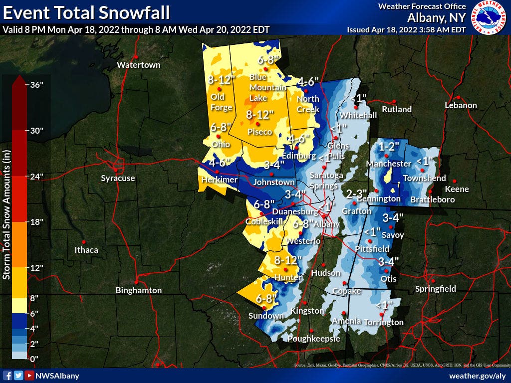
The widespread storm could dump more than an inch of rain on the region plus a foot of snow on the Catskills.

HUDSON VALLEY, NY — An April storm will drench the region overnight Monday. The National Weather Service has issued a coastal flood warning and wind advisory for Sound Shore communities, a gale warning for the Long Island Sound, a hazardous outlook for the mid-Hudson and a winter storm warning for western Ulster County.
For western Dutchess and eastern Ulster County, the storm system is expected to bring a mix of rain and snow. Light wet snowfall accumulations are possible, as are slippery travel conditions.
Snowfall rates on the west side of the valley could reach an inch per hour overnight into Tuesday morning. Travel could be very difficult, and the NWS recommended travelers Monday night bring along an extra flashlight, food, and water in case of an emergency.
Find out what's happening in Ossining-Croton-On-Hudsonfor free with the latest updates from Patch.
The hazardous conditions could affect the morning commute and the heavy wet snow could bring down some tree limbs and cause power outages.
While the National Weather Service forecasted snow accumulation of 5-12 inches, Hudson Valley Weather warned that local amounts could be higher.
Find out what's happening in Ossining-Croton-On-Hudsonfor free with the latest updates from Patch.
"Locations above 1500' may see 6"+ of heavy wet snowfall. Areas above 2000' across the western Catskills may approach 12" of snow. With the uninhabited highest peaks and summits over 3000' possibly exceeding that," Alex Marra and Bill Potter of Hudson Valley Weather said in their morning Facebook post. "If you or anyone you know is hiking or climbing across the higher terrain tonight or tomorrow it’s best to ensure they alter plans or are prepared for dangerous conditions."
For the entire region, winds of 25-35 mph with gusts to 50 mph will blow down tree limbs and blow around unsecured objects. A few/scattered trees and power lines could be downed. Travel will be difficult, especially for high-profile vehicles.
The wind advisory will be in effect from 8 p.m. to 6 a.m. along the Sound.
The gale warning will be in effect from 6 p.m. to 6 a.m. for all coastal waters.
Around 1.5 inches of rain is expected. Minor urban and poor drainage flooding is possible. There is also an isolated, localized flash flood threat near fast-responding rivers and streams.

The most significant coastal flooding is expected to be along the western portion of the Long Island Sound. The Coastal Flood Warnings and Advisories are for the times of high tide late Monday night.
As the nor'easter departs, it'll leave the region wet and cold.
"After New York City hit 73 degrees Fahrenheit on Saturday, over 10 degrees above average for this time of year, the storm is forecast to prevent temperatures from rising past the lower 50s instead through Tuesday. Some spots in the interior Northeast could fail to surpass 40 F in the afternoon," said Jessica Storm, AccuWeather Meteorologist.
Here's the workweek forecast from the NWS based on Poughkeepsie.
- Monday - Increasing clouds, with a high near 58. Northeast wind 5 to 13 mph becoming southeast in the afternoon.
- Monday night -Rain. Low around 35. Southeast wind 9 to 15 mph becoming northeast after midnight. Winds could gust as high as 26 mph. Chance of precipitation is 100%. New precipitation amounts between three quarters and one inch possible.
- Tuesday -A chance of rain, mainly before 3pm. Cloudy, then gradually becoming mostly sunny, with a high near 50. West wind 10 to 16 mph. Chance of precipitation is 40%. New precipitation amounts between a tenth and quarter of an inch possible.
- Tuesday Night -Partly cloudy, with a low around 39. West wind 9 to 11 mph.
- Wednesday -Sunny, with a high near 55. West wind 9 to 11 mph.
- Wednesday Night -Partly cloudy, with a low around 36.
- Thursday -Mostly cloudy, with a high near 61.
- Thursday Night -Mostly cloudy, with a low around 45.
- Friday -Mostly sunny, with a high near 66.
- Friday Night -Partly cloudy, with a low around 42.
Get more local news delivered straight to your inbox. Sign up for free Patch newsletters and alerts.


