Community Corner
WEATHER UPDATE: Snow, Ice Set to Cause a Monday Mess
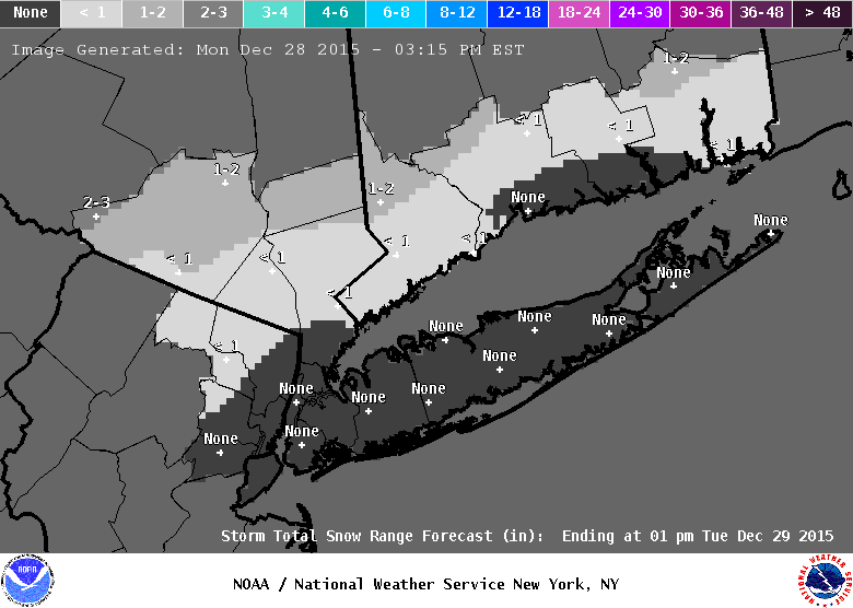
The latest storm forecast for the island.


Snowfall projections for a Sunday night and Monday winter storm have declined for Long Island, but enough white stuff and rain is still expected to fall to cause treacherous conditions on the roadways.
A winter storm warning is now in effect for northern Nassau and northwest Suffolk County until 6 p.m. Monday. The rest of the island is under a winter storm advisory until 6 p.m. Monday.
Find out what's happening in Plainviewfor free with the latest updates from Patch.
- Sign up for Patch weather and breaking news alerts here
Northern Nassau/northwest Suffolk
Snow accumulations of 2 to 5 inches, with one or two tenths of an inch of ice is expected for areas under the winter storm warning, according to the National Weather Service. Heavy snow may fall at a rate of 1-2 inches per hour late Sunday night into Monday morning.
Find out what's happening in Plainviewfor free with the latest updates from Patch.
The snow will change to heavy rain and freezing rain Monday morning and then back to a wintry mix in the afternoon, the NWS says. The snowfall range could be 1 to 2 inches higher or lower based on the timing of the changeover to rain in the morning.
Southern Long Island/North Fork
Snow accumulations of 1 to 4 inches along with a few hundredths of an inch of ice. The lowest snow totals are likely on the South Fork. Brief heavy snow late Sunday night into early Monday morning will change to heavy rain and then back to a wintry mix in the late afternoon.
The snowfall range could be an inch higher or lower based on the timing of the changeover to rain in the morning. Heavy rain and snow-clogged storm drains could cause some flooding, the NWS says.
The Roads
The roads are expected to be in poor shape for both the morning and afternoon commutes.
Temperatures will fall rapidly on Monday afternoon to the mid and upper 20s and then continue to fall into the teens by midnight.
“This will likely result in a flash freeze of standing water and slush,” the NWS said of the temperature plunge. ”This could make the afternoon commute just as treacherous as the morning commute.”
Wind
The strongest winds will be along the coast.
- E 15-20 gusts to 25 mph Sunday night/early Monday morning
- N 10-20 gusts to 25 mph Monday afternoon
- NW 20-30 gusts to 35-40 mph Monday night
Wind chill temperatures will drop to 5 to 15 degrees below zero on Monday night.
More on Patch:
- Blizzard 2015: Long Island Snowfall Totals
- Levittown Man Found Shot to Death at Jericho Gas Station
- Huntington Man Sentenced to Prison for Financial Fraud
- DA: Greenport Man Indicted For Fatal DWI Crash
- East End Returning to Normal After Blizzard
- Police: Woman Seriously Hurt After Being Stuck by Truck With Plow Attachment
- Massapequa Teen Overcomes Hearing Loss, Wins Scholarship
- DA: Oceanside Gym Owner Indicted for Stealing from Clients
- Two Charged in Dix Hills Gas Station Robbery
- Cops: Glen Cove Man Faces Leandra’s Law Charges After Jericho Crash
Get more local news delivered straight to your inbox. Sign up for free Patch newsletters and alerts.