Crime & Safety
Record-Breaking Warmth For Christmas Eve, Christmas on Long Island
Does Santa even own a pair of shorts?

BY SIMONE WILSON
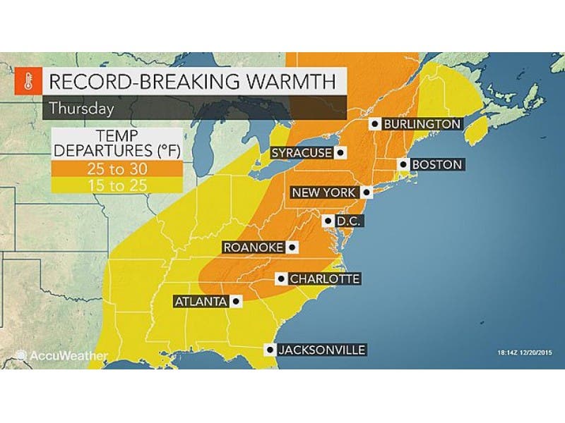
If Christmas Eve temperatures on Long Island come anywhere near the National Weather Service (NWS) forecast of 68 degrees, this will be the warmest Dec. 24 on record.
The previous record was 60 degrees, set just last year. Long Island’s average for Dec. 24 is 33 degrees.
Find out what's happening in Sachemfor free with the latest updates from Patch.
Temps on Christmas Day are expected to drop back down to 60 degrees, but that will still easily break the daily record of 56 degrees, which was hit last year and in 1986 at Long Island MacArthur Airport.
Not only will this Christmas be a hot one, it’ll be a muggy one, too: According to AccuWeather, ”a surge of higher dewpoints will arrive with the warmth, making Christmas Eve actually feel humid by December standards.”
Find out what's happening in Sachemfor free with the latest updates from Patch.
There’s a 30 percent chance of rain on Christmas Eve, according to the NWS. Christmas Day, however, is expected to be “mostly sunny.”
The rest of the East Coast is expecting similar, record-setting temperatures this holiday. “The only chance of a white Christmas will be in the Tug Hill region of New York state, east of Lake Ontario, and northern Maine,” writes AccuWeather meteorologist Kristina Pydynowski.
Below, your full Christmas-week forecast, courtesy of the NWS.
Monday Night- A chance of rain, mainly after 3am. Cloudy, with a low around 48. Southwest wind 8 to 13 mph. Chance of precipitation is 40%.
Tuesday- Rain likely, mainly between 9am and 2pm. Cloudy, with a high near 59. South wind 8 to 11 mph. Chance of precipitation is 60%. New precipitation amounts between a tenth and quarter of an inch possible.
Tuesday Night- Areas of fog. Otherwise, mostly cloudy, with a low around 49. West wind 5 to 9 mph becoming calm after midnight.
Wednesday- Rain, mainly after 1pm. The rain could be heavy at times. Areas of fog. High near 60. Light east wind becoming southeast 9 to 14 mph in the morning. Chance of precipitation is 90%. New precipitation amounts between a half and three quarters of an inch possible.
Wednesday Night- Rain before midnight, then a chance of drizzle or light rain after midnight. The rain could be heavy at times. Areas of fog. Temperature rising to around 61 by 1am. Southwest wind 15 to 17 mph. Chance of precipitation is 90%. New precipitation amounts between a quarter and half of an inch possible.
Thursday- A slight chance of drizzle or light rain before 9am, then a slight chance of showers after 9am. Areas of fog before 9am. Otherwise, mostly cloudy, with a high near 68. Chance of precipitation is 20%.
Thursday Night- A chance of showers before midnight. Mostly cloudy, with a low around 55. Chance of precipitation is 30%.
Christmas Day- Mostly sunny, with a high near 61.
Friday Night- Partly cloudy, with a low around 45.
Saturday- Mostly cloudy, with a high near 53.
Image via AccuWeather
Get more local news delivered straight to your inbox. Sign up for free Patch newsletters and alerts.