Weather
Long Island Weather: Blizzard Conditions Likely Tuesday
Here comes the storm. Spring is six days away.

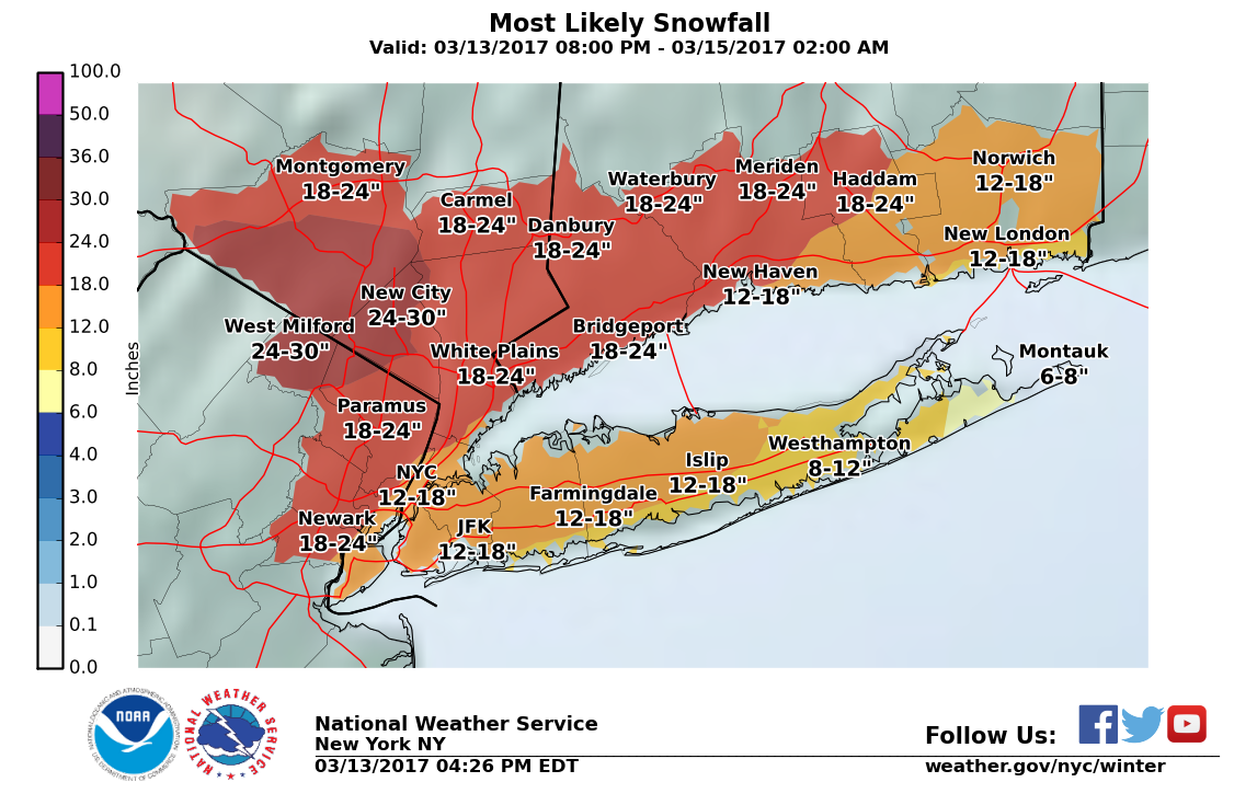
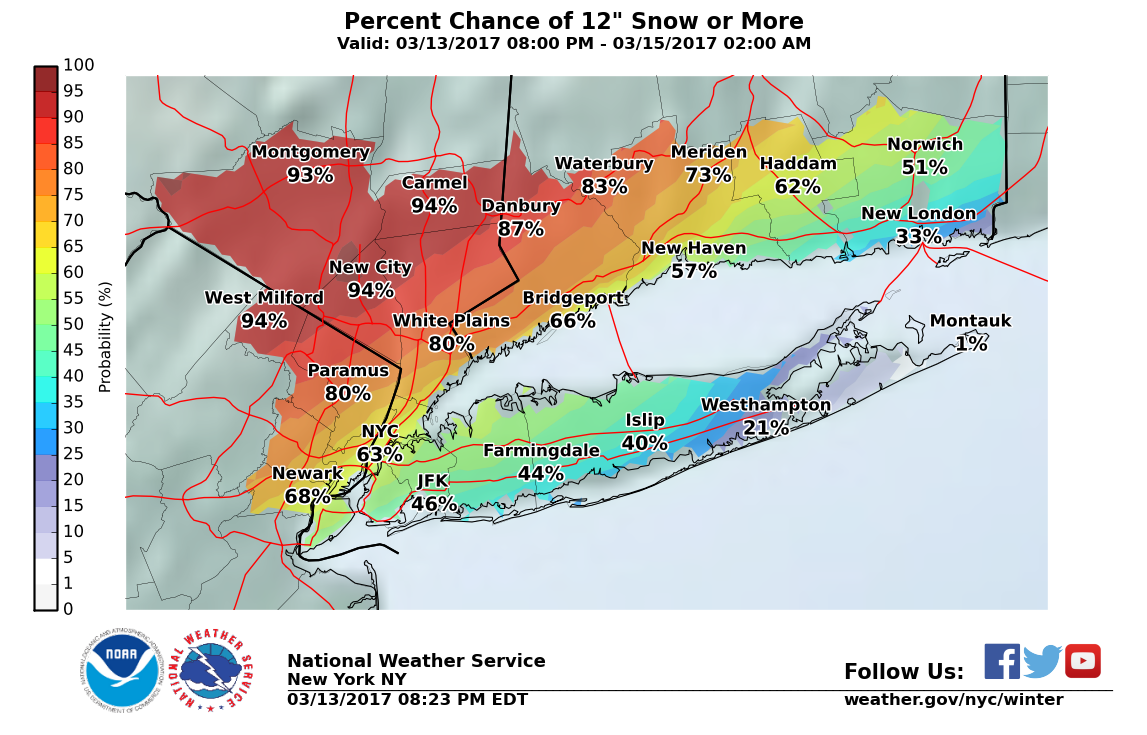
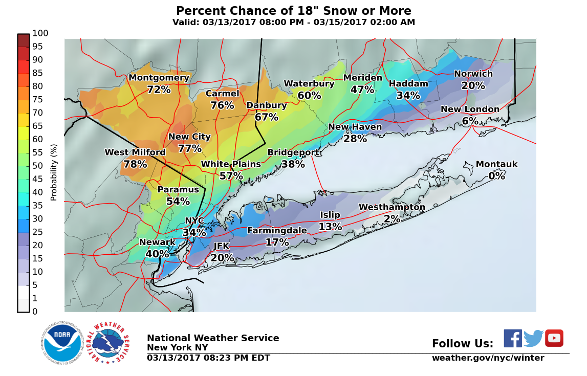
A major winter storm remains on track to drop up to 18 inches of snow on parts of Long Island Tuesday, according to the National Weather Service.
The storm has continued a westward shift, though, leading to a drop in snow total estimates for the East End and the South Shore, where mixed precipitation may limit snow accumulation. (For updates on the incoming storm and other local stories that affect you, subscribe to Patch's daily newsletter and breaking news alerts for your Long Island neighborhood.)
The northwest movement of the rain/snow line Tuesday morning will also have significant effects on the snowfall forecast for the island, the NWS says. Craig Allen, the chief meteorologist for WCBS-AM/880, believes the current NWS snow projections for the island are too high.
Find out what's happening in Sayville-Bayportfor free with the latest updates from Patch.
"If latest trends are correct, mix/change is inevitable and could keep amounts to 6" or so," Allen wrote on his Facebook page. "Or, 6-10 may still occur then get washed down by rain."
A blizzard warning for Nassau County and western Suffolk, and a winter storm warning for eastern Suffolk is in effect all day Tuesday. Wind gusts of 50-60 mph are possible, with the strongest winds expected on the East End.
Find out what's happening in Sayville-Bayportfor free with the latest updates from Patch.
Travel will be dangerous due to whiteout conditions at times and several roads may become impassable, the NWS says. Power outages and structural damage from the weight of wet snow are also possible.
The precipitation will begin as all snow across the island early Tuesday and is expected to fall at a rate of 1-2 inches per hour, with the potential for up to 4 inches per hour, the NWS says. Minor to moderate coastal flooding is possible during high tide cycles Tuesday.
RELATED: How Approaching Blizzard May Affect Long Island Rail Road Service
Gov. Andrew Cuomo has declared a state of emergency for the entire state in anticipation of the storm, which could dump up to 2 feet of snow in the Hudson Valley.
"I strongly urge everyone to limit unnecessary travel on Tuesday, and if you must drive, please plan ahead, be careful, and stay safe," Cuomo said.
Suffolk County Executive Steve Bellone has also declared a state of emergency for Suffolk as of midnight.
Watching above-freezing mid-level temps get eroded by intense lift (here over NJ and NYC) never gets old. Ptype forecasting difficult here. pic.twitter.com/ZkqBK836AF
— Levi Cowan (@TropicalTidbits) March 13, 2017
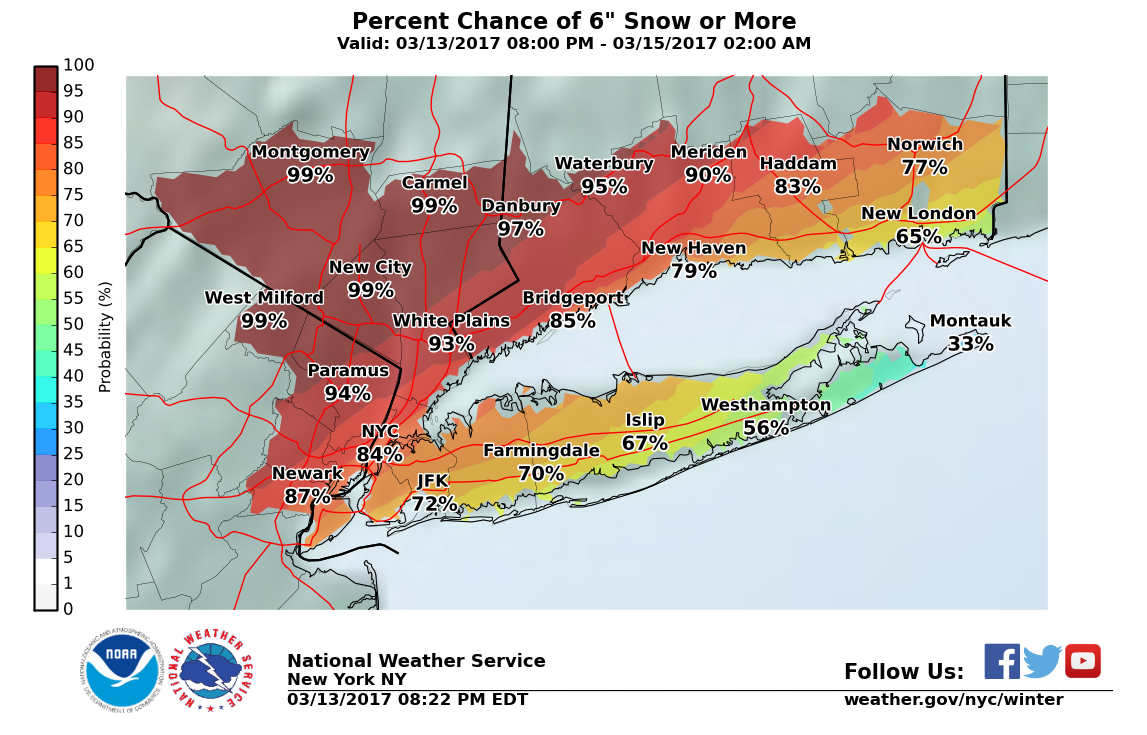
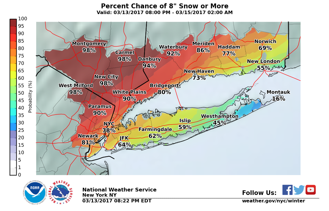
Find the full forecast and maps showing the odds of various snowfall amounts below. You can read the latest NWS storm briefing here.
Monday Night- Snow likely, mainly after 1am. Cloudy, with a steady temperature around 29. Wind chill values between 15 and 25. East wind 5 to 13 mph. Chance of precipitation is 70%. Total nighttime snow accumulation of 2 to 4 inches possible.
Tuesday- Rain, snow, and sleet before 2pm, then rain and sleet between 2pm and 4pm, then rain and sleet, possibly mixed with snow and freezing drizzle after 4pm. The snow and sleet could be heavy at times. Areas of blowing snow before noon, then areas of blowing snow after 4pm. Temperature rising to near 34 by noon, then falling to around 27 during the remainder of the day. Wind chill values between 10 and 20. Windy, with a northeast wind 32 to 37 mph, with gusts as high as 55 mph. Chance of precipitation is 100%. Little or no ice accumulation expected. New snow and sleet accumulation of 6 to 10 inches possible.
Tuesday Night- Snow and freezing drizzle likely before 10pm, then a chance of snow between 10pm and 3am. Mostly cloudy, with a low around 21. Wind chill values between 10 and 15. Windy, with a northwest wind 23 to 28 mph decreasing to 13 to 18 mph after midnight. Winds could gust as high as 38 mph. Chance of precipitation is 60%. Little or no ice accumulation expected. New snow accumulation of less than one inch possible.
Wednesday- Scattered snow showers, mainly after 11am. Mostly cloudy, with a high near 31. Wind chill values between 10 and 15. Northwest wind 11 to 17 mph, with gusts as high as 36 mph. Chance of precipitation is 30%.
Wednesday Night- Mostly cloudy, with a low around 20. Blustery, with a northwest wind 14 to 20 mph, with gusts as high as 34 mph.
Main Photo: Flickr/CreativeCommons/Anthony Quintano
Get more local news delivered straight to your inbox. Sign up for free Patch newsletters and alerts.