Weather
Tropical Storm Warning, Storm Surge Watch in Effect For Long Island
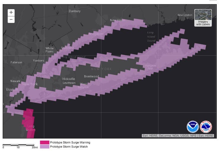
Map released of areas in danger of life-threatening storm surge as Hermine continues to strengthen. State of emergency declared in Suffolk.


UPDATE 4 p.m.: Suffolk County Executive Steve Bellone has declared a state of emergency in Suffolk. Officials have also issued a voluntary evacuation of Fire Island.
A tropical storm warning is now in effect for Long Island as Hermine, now classified as a tropical depression, churns its dangerous path up the East Coast. (For continued updates on the storm, including news on power outages and road closures, sign up for Patch news alerts here.)
Find out what's happening in Sayville-Bayportfor free with the latest updates from Patch.
The National Weather Service has released the below map of towns along Long Island's north and south shores, as well as the Twin Forks, that it says are at risk for life-threatening storm surge (find an interactive map here).
As of 2 p.m. Saturday, Hermine was about 330 miles south of New York City and moving east at 10 mph. Maximum sustained winds have now reached 70 mph, just 4 mph less than hurricane force. The storm is expected to keep strengthening and it is projected to reach hurricane status by 8 p.m. Sunday when it will be centered a couple hundred miles south of Long Island, the National Hurricane Center says.
Find out what's happening in Sayville-Bayportfor free with the latest updates from Patch.
"It’s unclear whether Hermine will again be technically classified as a tropical storm or hurricane rather than a post-tropical storm, but that point is moot in terms of impact," Bob Henson and Jeff Masters wrote on WunderBlog. "Computer models are near-unanimous in bringing Hermine’s top winds up to or above hurricane strength for at least a few hours on Sunday night or Monday."
Tropical storm conditions are now expected for four straight days on the island, from Sunday through Wednesday, as Hermine practically stalls in the Atlantic Ocean. Moderate to major coastal flooding on Long Island is likely from Sunday into Monday and possibly Tuesday.
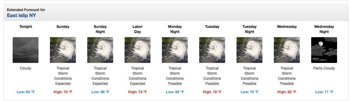
The National Weather Service's extended forecast for Long Island.
"Incidents of coastal flooding and beach erosion will only increase and become more severe with each passing day of the winds driving the ocean water onshore and surf pounding the beaches," AccuWeather Senior Meteorologist Kristina Pydynowski said.
"In some places, the peak surge could be comparable to that experienced during Hurricane Irene in 2011, with at least some level of high water persisting for days on end," according to WunderBlog.
Locally heavy rainfall producing localized fresh water flooding remains a relatively low threat, the NWS says.
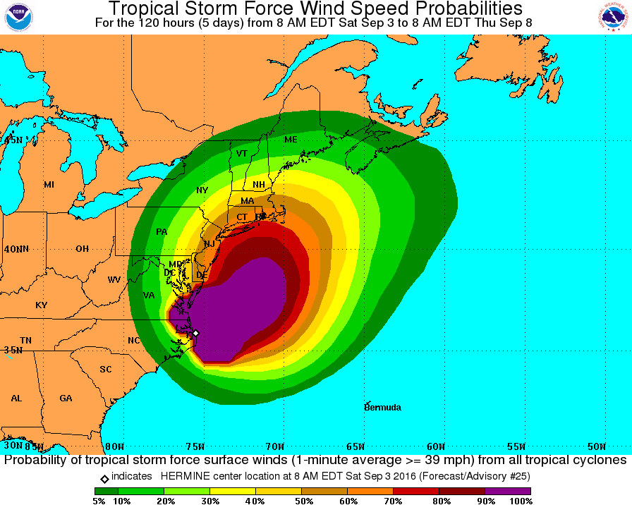
The odds of tropical storm force winds (39-73 mph) on Long Island have now risen to 60 percent in Nassau and 70 percent in Suffolk.
The New York State Emergency Operations Center will be activated on Sunday at noon and Gov. Andrew Cuomo has directed state officials from responding agencies to immediately be on alert for the storm. State Emergency Personnel are actively monitoring the storm as it approaches and stockpiled resources in the downstate region – including sandbags, high-axle vehicles, pumps and generators – are prepared for deployment, Cuomo said.
A state of emergency was declared Saturday afternoon in three counties along the New Jersey Shore, which was devastated during Hurricane Sandy four years ago.
Find the latest Hurricane Local Statement for the region detailing all of Hermine's potential impacts here.
#Hermine as it heads back out over warm water. Post tropical or tropical expect huge coastal impacts regardless pic.twitter.com/LzurafEGmR
— Jim Cantore (@JimCantore) September 3, 2016
3 feet of beach erosion in Beach Haven Long Beach Island NJ. Angry, angry ocean. @JimCantore @TWCBreaking @phillywx pic.twitter.com/vMXVHrZkj6
— Shawn Hink (@SmHink) September 3, 2016
Hermine has moved off NC coast and is starting to strengthen.Tropical storm watches/warning extended up the coast. pic.twitter.com/EbXGltXrX8
— NWS Eastern Region (@NWSEastern) September 3, 2016
Get more local news delivered straight to your inbox. Sign up for free Patch newsletters and alerts.