Community Corner
Surprise! Heavier Than Expected Snow Slams Long Island
Check out the latest wintry forecast.

UPDATE: 5:45 p.m. Sunday: The National Weather Service has issued the following special weather statement:
BANDS OF MODERATE TO LOCALLY HEAVY SNOW WILL CONTINUE TO PRODUCE SNOWFALL AT RATES OF UP TO AN INCH PER HOUR...AND VISIBILITY BETWEEN ONE QUARTER AND ONE HALF MILE...CREATING HAZARDOUS DRIVING CONDITIONS. THE SNOW MAY MIX WITH SLEET AT TIMES IN AND AROUND NEW YORK CITY. EXERCISE EXTRA CAUTION IF OUT DRIVING OR WALKING. A WINTER STORM WARNING REMAINS IN EFFECT FOR SUFFOLK COUNTY AND COASTAL MIDDLESEX AND NEW LONDON COUNTIES...AND A WINTER WEATHER ADVISORY REMAINS IN EFFECT ELSEWHERE.
UPDATE 5:15 p.m. Sunday: Heavier Than Expected Snow Slams Nassau
Find out what's happening in Smithtownfor free with the latest updates from Patch.
UPDATE 4 p.m. Sunday: Winter Storm Warning Issued for Suffolk County
UPDATE 3 p.m Sunday: The National Weather Service has issued the following special weather statement:
Find out what's happening in Smithtownfor free with the latest updates from Patch.
A BAND OF MODERATE TO LOCALLY HEAVY SNOW OVER THE NEW YORK CITY METROPOLITAN AREA AND LONG ISLAND WILL PRODUCE SNOWFALL RATES OF AN INCH PER HOUR...AND VISIBILITY BETWEEN ONE QUARTER AND ONE HALF MILE. THIS IS CREATING HAZARDOUS DRIVING CONDITIONS...SO EXERCISE EXTRA CAUTION IF OUT DRIVING LATE THIS AFTERNOON.
Original story:
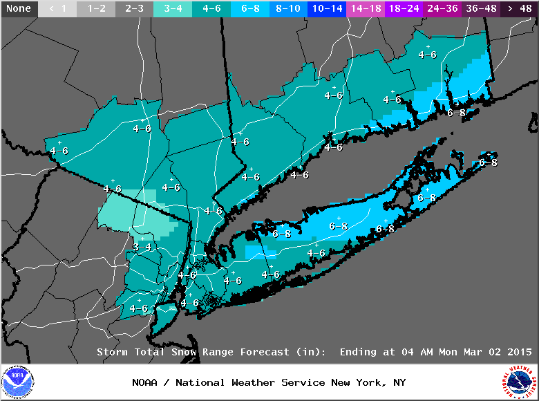
The National Weather Service has issued a winter weather advisory for Long island, with 2-4 inches of snow expected for most of Long Island.
The winter weather advisory went into effect at 10 a.m. Sunday and lasts until 7 a.m. Monday.
Current snowfall estimates vary across the island. The southern half of the island is in line for 2-3 inches. Most of the northern half, as well as New York City, will likely see 3-4 inches. There is a chance for 4-6 inches for some areas along the North Shore.
- Sign up for weather and breaking news alerts from Patch here
Snow is expected to begin Sunday afternoon on Long Island. It will mix with or change to freezing rain across the region on Sunday evening. The precipitation will taper off from west to east after midnight, the NWS says.
Up to a tenth of an inch of ice is also expected from the storm.
“Snow covered surfaces, coated with ice in areas, will cause travel difficulties,” the winter weather advisory reads. “The snow will also hide already icy spots.”
Things will will dry up on Monday, but rain and snow will be back in the forecast from Tuesday night into Thursday.
Any snow that does fall over the next week will add to already hefty snowfall totals this winter on Long Island. Through Feb. 22, MacArthur Airport had recorded 44 inches of snow. The average snowfall total for an entire winter at the airport: 24.8 inches.
Spring. 19 days away.
More on Patch:
- Long Island Man Spends 10 Days in Hospital After iPhone Explodes in His Pocket
- Man Killed After Crashing Into Snow Bank, Cement Wall in Deer Park
- Long Island Man Competing on ‘Survivor’
- Police: Woman Critically Injured in Overnight Shooting in West Babylon
- Long Island Man Killed in NJ Crash With Tractor-Trailer
- Police: Wooden Figure in Sweatshirt Does Not Count as Passenger in HOV Lane
- Two Men Seriously Hurt in North Patchogue Crash
- DA: Long Island Gym Owner Pleads Guilty to Stealing from Clients
Get more local news delivered straight to your inbox. Sign up for free Patch newsletters and alerts.